Login
Register


MVY
Martha's Vineyard Airport
Official FAA Data Effective 2026-01-22 0901Z
Chart Supplement

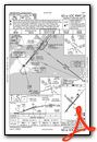
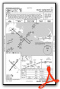
KMVY Airport Diagram

VFR Chart of KMVY
Sectional Charts at SkyVector.com
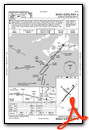
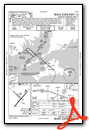
IFR Chart of KMVY
Enroute Charts at SkyVector.com
Location Information for KMVY
Coordinates: N41°23.61' / W70°36.83'Located 03 miles S of Vineyard Haven, Massachusetts on 688 acres of land. View all Airports in Massachusetts.
Surveyed Elevation is 66 feet MSL.
Operations Data
|
|
Airport Communications
| ATIS: | 126.25 (508-693-7685) |
|---|---|
| ASOS: | 126.25 Tel. 508-696-6988 |
| VINEYARD TOWER: | 121.4 |
| VINEYARD GROUND: | 124.35 |
| BOSTON APPROACH: | 133.75 |
| BOSTON DEPARTURE: | 133.75 |
| CLEARANCE DELIVERY: | 124.35 119.7 ;WHEN TWR CLSD |
| EMERG: | 121.5 |
| UNICOM: | 122.950 |
| CTAF: | 121.400 |
| ATIS at FMH (16.5 N): | 236.825 |
| ASOS at FMH (16.6 N): | 508-968-6562 |
| ATIS at HYA (22.3 NE): | 123.8 |
Nearby Navigation Aids
|
| ||||||||||||||||||||||||||||||||||||||||||||||||


Runway 06/24
| Dimensions: | 5504 x 100 feet / 1678 x 30 meters | |
|---|---|---|
| Surface: | Asphalt / Grooved in Fair Condition | |
| Weight Limits: | S-65, D-108, ST-185
PCR VALUE: 200/F/A/X/T
| |
| Edge Lighting: | High Intensity | |
| Runway 06 | Runway 24 | |
| Coordinates: | N41°23.20' / W70°37.16' | N41°23.89' / W70°36.38' |
| Elevation: | 53.9 | 62.6 |
| Traffic Pattern: | Left | Right |
| Runway Heading: | 41° True | 221° True |
| Declared Distances: | TORA:5504 TODA:5504 ASDA:5504 LDA:5504 | TORA:5504 TODA:5504 ASDA:5504 LDA:5504 |
| Markings: | Precision Instrument in good condition. | Precision Instrument in good condition. |
| Glide Slope Indicator | P4R (3.00° Glide Path Angle) | P4R (3.00° Glide Path Angle) |
| RVR Equipment | Rollout | Touchdown |
| Approach Lights: | MALSR 1,400 Foot Medium-intensity Approach Lighting System with runway alignment indicator lights. | |
| REIL: | Yes | |
| Obstacles: | 14 ft Trees 700 ft from runway, 350 ft right of center | |
Runway 15/33
RWY 15/33 NOT AVBL FOR PART 121/PART 380 OPS WITH SKED PAX CARRYING OPS MORE THAN 9 PAX SEATS AND NON-SKED PAX CARRYING OPS MORE THAN 30 PAX SEATS. | ||
| Dimensions: | 3327 x 75 feet / 1014 x 23 meters | |
|---|---|---|
| Surface: | Asphalt in Good Condition | |
| Weight Limits: | S-31, D-45, ST-61
PCR VALUE: 90/F/A/X/T
| |
| Edge Lighting: | Medium Intensity | |
| Runway 15 | Runway 33 | |
| Coordinates: | N41°23.89' / W70°37.21' | N41°23.53' / W70°36.66' |
| Elevation: | 66.9 | 56.9 |
| Traffic Pattern: | Left | Right |
| Runway Heading: | 131° True | 311° True |
| Declared Distances: | TORA:3327 TODA:3327 ASDA:3327 LDA:3327 | TORA:3327 TODA:3327 ASDA:3327 LDA:3327 |
| Markings: | Non-Precision Instrument in good condition. | Non-Precision Instrument in good condition. |
| REIL: | Yes | |
| Obstacles: | 40 ft Trees 1500 ft from runway | 52 ft Trees 2000 ft from runway, 175 ft right of center |
Services Available
| Fuel: | 100LL (blue), Jet-A |
|---|---|
| Transient Storage: | Tiedowns |
| Airframe Repair: | MINOR |
| Engine Repair: | MINOR |
| Bottled Oxygen: | NONE |
| Bulk Oxygen: | NONE |
| Other Services: | AIR FREIGHT SERVICES,CHARTER SERVICE |
Ownership Information
| Ownership: | Publicly owned | |
|---|---|---|
| Owner: | COUNTY OF DUKES COUNTY | |
| 71 AIRPORT RD | ||
| VINEYARD HAVEN, MA 02568 | ||
| 508-693-7022 | ||
| Manager: | GEOFFREY R. FREEMAN | |
| 71 AIRPORT RD | ||
| VINEYARD HAVEN, MA 02568 | ||
| 508-693-7022 | ||
Other Remarks
- TWY D FM RWY 06 TO RWY 15 CLSD TO ACFT WITH OVR 9 PAX.
- ARPT HAS NOISE ABATEMENT PROCS. CTC OPNS 508-693-7022. AVOID RESIDENTIAL AREAS SW OF ARPT.
- HELS PROHIBITED FM HOVER TAXI, LDG AND TKOF FM T-HNGRS.
- CURFEW ON ARRS & DEPS BTN 2200-0600.
- WHEN ATCT CLSD ACTVT MALSR RWY 24; REIL RWY 33; HIRL RWY 06/24; MIRL RWY 15/33 - CTAF.
Weather Minimums

Instrument Approach Procedure (IAP) Charts


Nearby Airports with Instrument Procedures
| ID | Name | Heading / Distance | ||
|---|---|---|---|---|
 |
5B6 | Falmouth Airpark Airport | 016° | 12.0 |
|
KFMH | Cape Cod Coast Guard Air Station Airport | 014° | 16.5 |
|
KHYA | Cape Cod Gateway Airport | 042° | 22.4 |
|
KEWB | New Bedford Regional Airport | 317° | 23.0 |
|
KACK | Nantucket Memorial Airport | 108° | 26.4 |
|
KUUU | Newport State Airport | 285° | 31.3 |
|
KPYM | Plymouth Municipal Airport | 350° | 31.3 |
|
KCQX | Chatham Municipal Airport | 057° | 33.2 |
|
KTAN | Taunton Municipal/King Field Airport | 328° | 34.0 |
|
KOQU | Quonset State Airport | 289° | 38.0 |
|
KPVD | Rhode Island Tf Green International Airport | 298° | 41.6 |
|
KGHG | Marshfield Municipal - George Harlow Field Airport | 356° | 42.3 |
Airport Images
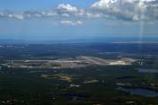
By: len.emery


