Login
Register


HYA
Cape Cod Gateway Airport
Official FAA Data Effective 2025-12-25 0901Z
Chart Supplement

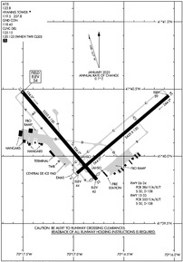
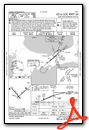
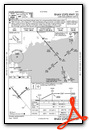
KHYA Airport Diagram
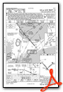
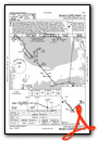
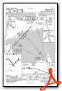
VFR Chart of KHYA
Sectional Charts at SkyVector.com
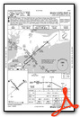
IFR Chart of KHYA
Enroute Charts at SkyVector.com
Location Information for KHYA
Coordinates: N41°40.16' / W70°16.82'Located 01 miles N of Hyannis, Massachusetts on 639 acres of land. View all Airports in Massachusetts.
Surveyed Elevation is 54 feet MSL.
Operations Data
|
|
Airport Communications
| ATIS: | 123.8 (508-778-1143) |
|---|---|
| ASOS: | Tel. 508-862-2601 |
| HYANNIS TOWER: | 119.5 257.8 |
| HYANNIS GROUND: | 118.45 |
| BOSTON APPROACH: | 118.2 284.6 |
| BOSTON DEPARTURE: | 118.2 284.6 |
| CLEARANCE DELIVERY: | 125.15 120.125 ;WHEN TWR CLSD |
| UNICOM: | 122.950 |
| CTAF: | 119.500 |
| ASOS at FMH (10.9 W): | 508-968-6562 |
| ATIS at FMH (10.9 W): | 236.825 |
| ASOS at CQX (12.9 E): | 135.875 508-945-5034 |
Nearby Navigation Aids
|
| ||||||||||||||||||||||||||||||||||||||||||||||||


Runway 06/24
| Dimensions: | 5425 x 150 feet / 1654 x 46 meters | |
|---|---|---|
| Surface: | Asphalt / Grooved in Good Condition | |
| Weight Limits: | S-30, D-108
PCR VALUE: 384/F/A/X/T
| |
| Edge Lighting: | High Intensity | |
| Runway 06 | Runway 24 | |
| Coordinates: | N41°39.88' / W70°16.97' | N41°40.45' / W70°16.06' |
| Elevation: | 44.4 | 39.1 |
| Traffic Pattern: | Left | Left |
| Runway Heading: | 50° True | 230° True |
| Displaced Threshold: | 406 Feet | |
| Declared Distances: | TORA:5425 TODA:5425 ASDA:5425 LDA:5019 | TORA:5425 TODA:5425 ASDA:5425 LDA:5425 |
| Markings: | Precision Instrument in good condition. | Precision Instrument in good condition. |
| Glide Slope Indicator | P4L (3.00° Glide Path Angle) | P4L (3.00° Glide Path Angle) |
| RVR Equipment | Rollout | Touchdown |
| Approach Lights: | MALSF 1,400 Foot Medium-intensity Approach Lighting System with sequenced flashers. | |
| REIL: | Yes | |
| Obstacles: | 17 ft Tree 450 ft from runway, 300 ft left of center APCH RATIO 50:1 TO DTHR. |
20 ft Railroad 400 ft from runway, 300 ft left of center |
Runway 15/33
| Dimensions: | 5255 x 150 feet / 1602 x 46 meters | |
|---|---|---|
| Surface: | Asphalt / Grooved in Good Condition | |
| Weight Limits: | S-30, D-108
PCR VALUE: 355/F/A/X/T
| |
| Edge Lighting: | High Intensity | |
| Runway 15 | Runway 33 | |
| Coordinates: | N41°40.49' / W70°17.51' | N41°39.83' / W70°16.77' |
| Elevation: | 54.1 | 42.4 |
| Traffic Pattern: | Left | Left |
| Runway Heading: | 140° True | 320° True |
| Displaced Threshold: | 150 Feet APCH RATIO 34:1 TO DTHR. |
|
| Declared Distances: | TORA:5255 TODA:5255 ASDA:5255 LDA:5255 | TORA:5255 TODA:5255 ASDA:5255 LDA:5105 |
| Markings: | Precision Instrument in good condition. | Precision Instrument in good condition. |
| Glide Slope Indicator | P4L (3.00° Glide Path Angle) | |
| RVR Equipment | Touchdown | Rollout |
| Approach Lights: | MALSR 1,400 Foot Medium-intensity Approach Lighting System with runway alignment indicator lights. | |
| Obstacles: | 146 ft Power Line 5175 ft from runway | APCH RATIO 34:1 TO DTHR. |
Services Available
| Fuel: | 100LL (blue), Jet-A |
|---|---|
| Transient Storage: | Hangars,Tiedowns |
| Airframe Repair: | MAJOR |
| Engine Repair: | MAJOR |
| Bottled Oxygen: | NONE |
| Bulk Oxygen: | NONE |
| Other Services: | AIR FREIGHT SERVICES,AVIONICS,CHARTER SERVICE,PILOT INSTRUCTION,AIRCRAFT RENTAL,AIRCRAFT SALES |
Ownership Information
| Ownership: | Publicly owned | |
|---|---|---|
| Owner: | TOWN OF BARNSTABLE | |
| TOWN HALL 367 MAIN ST | ||
| HYANNIS, MA 02601 | ||
| 508-862-4600 | ||
| Manager: | MICHAEL NELSON | |
| 480 BARNSTABLE RD | ||
| HYANNIS, MA 02601 | ||
| 508-775-2020 | ||
Other Remarks
- ANT ON TANK 4600 FT SE ELEV 208 FT; STANDPIPE 7050 FT NORTH 236 FT; OBSTN LGTD.
- TWY B CLSD TO ACFT WITH WINGSPAN GTR THAN 118 FT. TWY B BTN TWY D & RWY 6-24 CLSD TO ACFT WITH WINGSPAN GTR THAN 78 FT.
- BE AWARE OF HIGH-SPD MIL JET & HVY HEL TFC VCNTY JOINT BASE CAPE COD. DO NOT CONFUSE JOINT BASE CAPE COD, 10NM W WITH CAPE COD GATEWAY.
- ARFF INDEX B SVCS PRVDD BTN 0600 AND 2159 LCL DLY. ARFF INDEX A SVCS PRVDD DRG OTR TIMES. FOR INDEX B SVCS BTN 2200 AND 0559 LCL, 1HR 30MIN PPR AT 508-778-7770.
- BIRDS, COYOTES ON & INVOF ARPT.
- ARPT HAS NOISE ABATEMENT CTC AMGR 508-778-7765.
- TGL OPS PROHIBITED BTN 2100-0559, PPR BY AMGR.
- ALL TSNT & GA PILOTS MUST CTC ARPT OPS ON FREQ 122.95 PRIOR TO ENG SHTDN FOR AIRFIELD ESCORT BTN 2200-0559 LCL.
- LDG FEE FOR ALL ACFT OVER 6000 LBS.
- ACTVT MALSR RWY 15; MALSF RWY 24; HIRL RWYS 06/24 & 15/33 - CTAF.
- ENGINEERING MTRLS ARST SYS (EMAS) 200 FT IN LEN BY 176 FT WID LCTD AT THE DER 24.
Weather Minimums
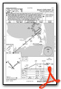
Instrument Approach Procedure (IAP) Charts
Nearby Airports with Instrument Procedures
| ID | Name | Heading / Distance | ||
|---|---|---|---|---|
 |
KFMH | Cape Cod Coast Guard Air Station Airport | 266° | 10.9 |
|
5B6 | Falmouth Airpark Airport | 246° | 12.7 |
|
KCQX | Chatham Municipal Airport | 084° | 13.1 |
|
KMVY | Martha's Vineyard Airport | 222° | 22.4 |
|
KPVC | Provincetown Municipal Airport | 006° | 24.3 |
|
KPYM | Plymouth Municipal Airport | 305° | 24.7 |
|
KACK | Nantucket Memorial Airport | 158° | 26.8 |
|
KEWB | New Bedford Regional Airport | 271° | 30.5 |
|
KGHG | Marshfield Municipal - George Harlow Field Airport | 325° | 31.1 |
|
KTAN | Taunton Municipal/King Field Airport | 290° | 35.2 |
|
1B9 | Mansfield Municipal Airport | 296° | 45.7 |
|
KUUU | Newport State Airport | 260° | 45.8 |
Airport Images
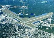
By: N1888E-young


