Login
Register


ADS
Addison Airport
Official FAA Data Effective 2026-01-22 0901Z
From the Flight Deck
Chart Supplement

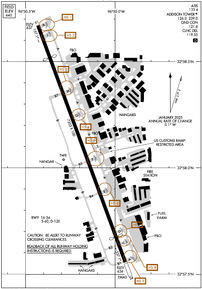
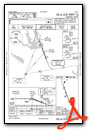
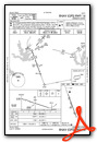
KADS Airport Diagram
VFR Chart of KADS
Sectional Charts at SkyVector.com
IFR Chart of KADS
Enroute Charts at SkyVector.com
Location Information for KADS
Coordinates: N32°58.11' / W96°50.19'Located 09 miles N of Dallas, Texas on 368 acres of land. View all Airports in Texas.
Surveyed Elevation is 644 feet MSL.
TPA: 956 FT AGL LIGHT ACFT, 1356 FT AGL LRG ACFT.
Operations Data
|
|
Airport Communications
| ATIS: | 133.4 (972-628-2439) |
|---|---|
| AWOS-3PT: | Tel. 972-386-4855 |
| ADDISON TOWER: | 126.0 239.0 |
| ADDISON GROUND: | 121.6 |
| LONE STAR APPROACH: | 124.3 282.275 |
| LONE STAR DEPARTURE: | 124.3 282.275 |
| CLEARANCE DELIVERY: | 119.55 |
| FINGR STAR: | 124.3 125.275 282.275 308.4 |
| BOTCH DP: | 124.3 282.275 |
| YEAGR STAR: | 125.2 343.65 |
| SWVAY STAR: | 135.975 379.9 |
| SLANT STAR: | 125.025 125.275 308.4 |
| GREGS STAR: | 118.1 306.95 |
| JOE POOL DP: | 124.3 282.275 |
| CTAF: | 126.000 |
| UNICOM: | 122.950 |
| EESAT STAR: | 125.025 125.275 308.4 |
| DALLAS AREA DP: | 124.3 282.275 |
| LOADS STAR: | 125.025 125.275 308.4 |
| SASIE STAR: | 124.3 282.275 |
| HERBZ STAR: | 118.1 306.95 |
| NANDR RNAV DP: | 124.3 282.275 |
| JFRYE STAR: | 118.1 306.95 |
| GARLAND DP: | 124.3 282.275 |
| ASOS at DAL (7.4 S): | 214-353-1551 |
| D-ATIS at DAL (7.4 S): | 120.15 |
| ASOS at DFW (10.3 SW): | 214-600-7784 |
Nearby Navigation Aids
|
| ||||||||||||||||||||||||||||||||||||||||||||||||||||||||||||


Runway 16/34
| Dimensions: | 7203 x 100 feet / 2195 x 30 meters | |
|---|---|---|
| Surface: | Asphalt / Grooved in Good Condition | |
| Weight Limits: | S-60, D-120 | |
| Edge Lighting: | High Intensity | |
| Runway 16 | Runway 34 | |
| Coordinates: | N32°58.67' / W96°50.43' | N32°57.56' / W96°49.94' |
| Elevation: | 636.7 | 635.9 |
| Traffic Pattern: | Left | Left |
| Runway Heading: | 160° True | 340° True |
| Displaced Threshold: | 979 Feet | 772 Feet |
| Declared Distances: | TORA:7203 TODA:7203 ASDA:7203 LDA:6224 | TORA:7203 TODA:7203 ASDA:7203 LDA:6431 |
| Markings: | Precision Instrument in good condition. | Precision Instrument in good condition. |
| Glide Slope Indicator | P4R (3.00° Glide Path Angle) | P4L (3.00° Glide Path Angle) |
| Approach Lights: | MALSR 1,400 Foot Medium-intensity Approach Lighting System with runway alignment indicator lights. | |
| REIL: | Yes | |
| Obstacles: | 10 ft Road 200 ft from runway, 500 ft right of center APCH SLOPE 10:1 TO DSPLCD THR OVR 40 FT TREE, 430 FT DSTC, 475 FT L. 10 FT ARPT PERIMETER RD, 0-200 FT DSTC, 275 FT R, 488 FT L |
10 ft Road 200 ft from runway, 500 ft left of center ANTENNA ON TOP OF BLDG. APCH SLOPE 17:1 TO DSPLCD THR OVR 28 FT POLE, 490 FT DSTC, 536 FT L. 10 FT ARPT PERIMETER RD, 0-200 FT DSTC, 320 FT L TO 460 FT R. |
Services Available
| Fuel: | 100LL (blue), Jet-A |
|---|---|
| Transient Storage: | Hangars,Tiedowns |
| Airframe Repair: | MAJOR |
| Engine Repair: | MAJOR |
| Bottled Oxygen: | HIGH |
| Bulk Oxygen: | LOW |
| Other Services: | AVIONICS,CHARTER SERVICE,PILOT INSTRUCTION,AIRCRAFT RENTAL,AIRCRAFT SALES,ANNUAL SURVEYING |
Ownership Information
| Ownership: | Publicly owned | |
|---|---|---|
| Owner: | TOWN OF ADDISON | |
| P.O. BOX 9010 | ||
| ADDISON, TX 75001 | ||
| 972-450-2800 | ||
| Manager: | JAIME EDROSA | |
| 4545 JIMMY DOOLITTLE DRIVE, SUITE 200 | ||
| ADDISON, TX 75001 | ||
| 972-392-4850 | ||
Other Remarks
- NUMEROUS 200 FT BLDGS WITHIN 1 MILE EAST AND SOUTH OF ARPT; TRANSMISSION TOWERS AND WATER TANKS WEST OF ARPT.
- AWOS-3 INFO ONLY AVBL WHEN ATCT CLSD. ATIS AVBL DURING TWR HRS.
- NO TGL WITHOUT AMGR APPROVAL.
- USER FEE ARPT. CPB OFC HRS M-F 1000-2100. 214-208-3636.
- BIRDS ON & INVOF ARPT.
- BE ALERT: RWY HLDG PTN MRKGS LCTD AT THE WEST EDGE OF TWY A.
- NOISE SENSITIVE AREAS SURROUND ARPT. PILOTS REQUESTED TO USE NBAA STD NOISE ABATEMENT PROCEDURES.
- ACTVT MALSR RWY 16; HIRL RWY 16/34 - CTAF.
- TPA: 956 FT AGL LIGHT ACFT, 1356 FT AGL LRG ACFT.
- EMAS NON-STD ARRESTING GEAR/SYSTEM: ENGINEERED MATERIALS ARRESTING SYSTEM (EMAS) 387 FT IN LENGTH BY 100 FT WIDTH LCTD 35 FT SETBACK FM DER 16.
Weather Minimums

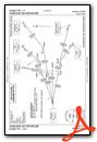
Standard Terminal Arrival (STAR) Charts


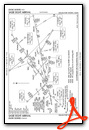


Instrument Approach Procedure (IAP) Charts


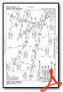
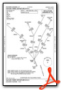
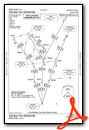
Departure Procedure (DP) Charts
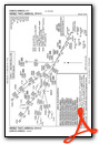
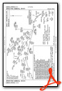
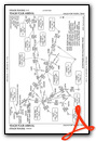
- BOTCH ONE (RNAV)
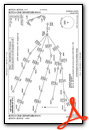
- BOTCH ONE (RNAV), CONT.1
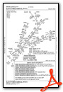
- DALLAS FOUR

- DALLAS FOUR, CONT.1

- GARLAND SIX
- GARLAND SIX, CONT.1
- JOE POOL EIGHT
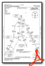
- JOE POOL EIGHT, CONT.1
- KINGDOM FIVE

- KINGDOM FIVE, CONT.1
- KUSSO TWO (RNAV)

- KUSSO TWO (RNAV), CONT.1
- NANDR THREE (RNAV)
- NANDR THREE (RNAV), CONT.1

- TEXOMA FIVE
- TEXOMA FIVE, CONT.1
- WORTH ONE
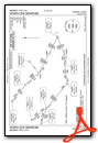
- WORTH ONE, CONT.1
Nearby Airports with Instrument Procedures
| ID | Name | Heading / Distance | ||
|---|---|---|---|---|
 |
KDAL | Dallas Love Field Airport | 185° | 7.4 |
|
KDFW | Dallas-Fort Worth International Airport | 247° | 11.0 |
|
KRBD | Dallas Exec Airport | 185° | 17.3 |
|
KTKI | Mckinney Ntl Airport | 044° | 17.7 |
|
KGPM | Grand Prairie Municipal Airport | 213° | 19.3 |
|
F46 | Ralph M Hall/Rockwall Municipal Airport | 096° | 20.4 |
|
KHQZ | Mesquite Metro Airport | 130° | 20.4 |
|
KGKY | Arlington Municipal Airport | 215° | 22.4 |
|
KDTO | Denton Enterprise Airport | 307° | 23.0 |
|
KLNC | Lancaster Regional Airport | 165° | 24.2 |
|
KAFW | Perot Field/Fort Worth Alliance Airport | 273° | 24.4 |
|
KFTW | Fort Worth Meacham International Airport | 251° | 28.0 |