Login
Register


UNK
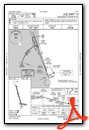
Unalakleet Airport
Official FAA Data Effective 2026-01-22 0901Z
Chart Supplement

VFR Chart of PAUN
Sectional Charts at SkyVector.com
IFR Chart of PAUN
Enroute Charts at SkyVector.com
Location Information for PAUN
Coordinates: N63°53.31' / W160°47.95'Located 01 miles N of Unalakleet, Alaska on 715 acres of land. View all Airports in Alaska.
Surveyed Elevation is 27 feet MSL.
Operations Data
|
|
Airport Communications
| AWOS-3P: | 132.25 Tel. 907-624-3051 |
|---|---|
| CTAF: | 123.000 |
| AWOS-3P at 2C7 (31.0 N): | 124.175 907-955-3896 |
| AWOS-3P at SMK (42.3 SW): | 119.275 907-923-6480 |
| AWOS-3P at ELI (58.1 NW): | 121.425 907-890-2014 |
- APCH/DEP SVC PRVDD BY ANCHORAGE ARTCC ON FREQS 135.7/335.5 (UNALAKLEET RCAG).
- COMMUNICATIONS PRVDD BY NOME FSS ON FREQ 122.30 (UNALAKLEET RCO).
Nearby Navigation Aids
|
| ||||||||||||||||||||||||

Runway 15/33
| Dimensions: | 5900 x 150 feet / 1798 x 46 meters | |
|---|---|---|
| Surface: | Asphalt / Grooved in Good Condition | |
| Edge Lighting: | High Intensity | |
| Runway 15 | Runway 33 | |
| Coordinates: | N63°53.88' / W160°48.36' | N63°52.95' / W160°47.76' |
| Elevation: | 25.7 | 24.7 |
| Traffic Pattern: | Right | Left |
| Runway Heading: | 164° True | 344° True |
| Markings: | Precision Instrument in good condition. | Precision Instrument in good condition. |
| Glide Slope Indicator | V4L (3.00° Glide Path Angle) | V4L (3.00° Glide Path Angle) |
| REIL: | Yes | |
| Obstacles: | 15 ft Road 200 ft from runway, 110 ft left of center | 25 ft Building 850 ft from runway, 300 ft right of center |
Runway 09/27
| Dimensions: | 1900 x 75 feet / 579 x 23 meters | |
|---|---|---|
| Surface: | Asphalt / Grooved in Good Condition | |
| Weight Limits: | 59 /F/B/X/T | |
| Edge Lighting: | Medium Intensity | |
| Runway 09 | Runway 27 | |
| Coordinates: | N63°53.01' / W160°47.94' | N63°52.96' / W160°47.24' |
| Elevation: | 24.1 | 19.3 |
| Traffic Pattern: | Left | Left |
| Runway Heading: | 98° True | 278° True |
| Markings: | Basic in good condition. | Basic in good condition. |
| Obstacles: | 20 ft Bridge 690 ft from runway, 310 ft left of center | |
Services Available
| Fuel: | 100LL (blue), Jet-A |
|---|---|
| Transient Storage: | Tiedowns TSNT PRKG NEAR DOT MAINT BLDG & RWY 27 THR. |
| Airframe Repair: | NOT AVAILABLE EMERG ONLY. |
| Engine Repair: | NOT AVAILABLE EMERG ONLY. |
| Bottled Oxygen: | NOT AVAILABLE |
| Bulk Oxygen: | NOT AVAILABLE |
| Other Services: | CARGO HANDLING SERVICES |
Ownership Information
| Ownership: | Publicly owned | |
|---|---|---|
| Owner: | ALASKA DOT&PF NORTHERN REGION | |
| NORTHERN REGION, 2301 PEGER RD | ||
| FAIRBANKS, AK 99701 | ||
| 907-451-2200 | ||
| Manager: | JOHN WILSON | EMAIL: JOHN.WILSON@ALASKA.GOV |
| PO BOX 192 | ||
| UNALAKLEET, AK 99684 | ||
| 907-625-1025 | ||
Other Remarks
- 299 FT TWR 2.4 NM E.
- SNOW REMOVAL & DEICING NA 1600-0800.
- RWY COND UNMNT; RCMD VISUAL INSP PRIOR TO LNDG.
- WX CAMERA AVBL ON INTERNET AT HTTPS://WEATHERCAMS.FAA.GOV.
- 100 FT UNLGT TWR 0.4 NM N OF THR.
- ACTVT REIL RWY 33; HIRL RWY 15/33; MIRL RWY 09/27 - CTAF. VASI RWY 15 & 33 ON CONSLY.
Weather Minimums


Instrument Approach Procedure (IAP) Charts


Departure Procedure Obstacles (DPO) Charts
Nearby Airports with Instrument Procedures
| ID | Name | Heading / Distance | ||
|---|---|---|---|---|
 |
PFSH | Shaktoolik Airport | 339° | 31.1 |
|
PAMK | St Michael Airport | 236° | 42.5 |
|
PFEL | Elim Airport | 319° | 58.3 |
|
PAKV | Kaltag Airport | 063° | 60.0 |
|
PAGX | Grayling Airport | 161° | 63.1 |
|
PAKK | Koyuk Alfred Adams Airport | 351° | 63.9 |
|
PAGL | Golovin Airport | 305° | 70.3 |
|
PANV | Anvik Airport | 167° | 76.5 |
|
PAHX | Shageluk Airport | 154° | 79.3 |
|
PAWM | White Mountain Airport | 306° | 83.6 |
|
PANU | Nulato Airport | 053° | 87.3 |
|
PFKO | Kotlik Airport | 236° | 89.9 |
Airport Images

By: Pilotmatt253


