Login
Register


ART
Watertown International Airport
Official FAA Data Effective 2026-02-19 0901Z
Chart Supplement

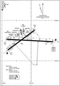
KART Airport Diagram
VFR Chart of KART
Sectional Charts at SkyVector.com
IFR Chart of KART
Enroute Charts at SkyVector.com
Location Information for KART
Coordinates: N43°59.51' / W76°1.17'Located 05 miles W of Watertown, New York on 1100 acres of land. View all Airports in New York.
Surveyed Elevation is 330 feet MSL.
Operations Data
|
|
Airport Communications
| ASOS: | 132.325 Tel. 315-639-4002 |
|---|---|
| WHEELER-SACK APPROACH: | 124.875 307.125 |
| WHEELER-SACK DEPARTURE: | 124.875 307.125 |
| IC: | 307.125 |
| CLEARANCE DELIVERY: | 120.8 |
| CTAF: | 123.000 |
| UNICOM: | 123.000 |
| ATIS at GTB (13.5 E): | 119.525 |
| ASOS at FZY (41.6 SW): | 119.275 315-598-8773 |
| AWOS-3 at OGS (47.7 NE): | 118.525 315-393-8982 |
Nearby Navigation Aids
|
| ||||||||||||||||||||||||||||||||||||||||||||||||||||||||||||


Runway 10/28
| Dimensions: | 7001 x 150 feet / 2134 x 46 meters | |
|---|---|---|
| Surface: | Asphalt / Grooved in Good Condition | |
| Weight Limits: | S-109, D-154, ST-254
PCR VALUE: 270/F/D/X/T
| |
| Edge Lighting: | Medium Intensity | |
| Runway 10 | Runway 28 | |
| Coordinates: | N43°59.54' / W76°1.84' | N43°59.48' / W76°0.25' |
| Elevation: | 309.1 | 330.8 |
| Traffic Pattern: | Left | Left |
| Runway Heading: | 93° True | 273° True |
| Declared Distances: | TORA:7001 TODA:7001 ASDA:7001 LDA:7001 | TORA:7001 TODA:7001 ASDA:7001 LDA:7001 |
| Markings: | Non-Precision Instrument in fair condition. | Precision Instrument in fair condition. |
| Glide Slope Indicator | P4L (3.00° Glide Path Angle) | P4L (3.00° Glide Path Angle) |
| Approach Lights: | MALSR 1,400 Foot Medium-intensity Approach Lighting System with runway alignment indicator lights. | |
| Obstacles: | 85 ft Trees 2700 ft from runway, 620 ft right of center | 85 ft Trees 2720 ft from runway, 90 ft right of center |
Runway 07/25
RWY 25 CALM WIND RWY. | ||
| Dimensions: | 4999 x 150 feet / 1524 x 46 meters | |
|---|---|---|
| Surface: | Asphalt / Grooved in Good Condition | |
| Weight Limits: | S-105, D-147, ST-244
PCR VALUE: 601/F/D/X/T
| |
| Edge Lighting: | High Intensity | |
| Runway 07 | Runway 25 | |
| Coordinates: | N43°59.27' / W76°1.80' | N43°59.76' / W76°0.88' |
| Elevation: | 310.3 | 323.8 |
| Traffic Pattern: | Left | Left |
| Runway Heading: | 53° True | 233° True |
| Declared Distances: | TORA:4999 TODA:4999 ASDA:4784 LDA:4784 | TORA:4999 TODA:4999 ASDA:4999 LDA:4999 |
| Markings: | Precision Instrument in good condition. | Non-Precision Instrument in good condition. |
| Glide Slope Indicator | P4L (3.00° Glide Path Angle) | P4L (3.00° Glide Path Angle) |
| Approach Lights: | MALSR 1,400 Foot Medium-intensity Approach Lighting System with runway alignment indicator lights. | |
| REIL: | Yes | |
| Obstacles: | 75 ft Trees 1520 ft from runway, 330 ft right of center | 70 ft Trees 1095 ft from runway, 520 ft left of center |
Services Available
| Fuel: | 100LL (blue), Jet-A |
|---|---|
| Transient Storage: | Hangars,Tiedowns |
| Airframe Repair: | MAJOR |
| Engine Repair: | MAJOR |
| Bottled Oxygen: | NOT AVAILABLE |
| Bulk Oxygen: | NOT AVAILABLE |
| Other Services: | AIR AMBULANCE SERVICES,CARGO HANDLING SERVICES,PILOT INSTRUCTION,AIRCRAFT RENTAL |
Ownership Information
| Ownership: | Publicly owned | |
|---|---|---|
| Owner: | COUNTY OF JEFFERSON | |
| 195 ARSENAL ST | ||
| WATERTOWN, NY 13601 | ||
| 315-785-3075 | ||
| Manager: | GRANT W. SUSSEY | |
| 22529 AIRPORT DR | ||
| DEXTER, NY 13634-3062 | ||
| 315-786-6002 | ||
Other Remarks
- DEER & BIRDS ON & INVOF ARPT.
- CTN: NGT VISION DEVICE OPS CONDUCTED IN TFC PAT AREA.
- RC MODEL ACT 4 NM N & 9 NM SSW BLW 400 FT.
- TWY LGTS NOT VSB USING NGT VISION GOGGLES.
- APN PRKG WT BRG CPTY: 68/F/C/X/T; S-120, D-239, DT-385.
- WX CAMERA AVBL AT WATERTOWNAIRPORT.COM.
- FOR CD IF UNA TO CTC WHEELER SACK ATCT ON FREQ, CTC WHEELER SACK ATCT AT 315-772-7105.
- CTN: RAPID HOT REFUELING ON TRML & GA RAMP.
- GND VEHICLES MNT CTAF.
- US CUSTOMS PRKG AT GA RAMP UNLESS ADZD BY CUSTOMS OR FBO.
- TKS, TYPE I & IV FLUIDS AVBL - CTC FBO.
- 24HR PPR FOR TRNSPN OF XPLOS - CTC AMGR.
- MEDEVAC ON ARPT. GIVEAWAY TO ACFT OR HEL USING MEDEVAC CS.
- WHEELED HEL REQSTD TO GND TAXI WHEN XNG GA RAMP.
- MIL HEL T ON & INVOF ARPT.
- PPR FOR USE OF UNIMPROVED SFCS - AMGR.
- TKS DE/ANTI ICING AVBL - FBO 315-786-6001.
- RWY/TWY COND UNMNTD AFT HRS.
- PAEW ALL SFCS APR-OCT. SN REMOVAL EQUIP OCT-APR.
- LNDG FEE OVR 6000 LB.
- 0LL FUEL AFT HRS: 315-816-2334 OR 315-466-6741.
- ACTVT MALSR RWY 07 & 28; REIL RWY 25; HIRL RWY 07/25; MIRL RWY 10/28; TWY LGTS - CTAF. PAPI RWYS 7, 10, 25 & 28 OPR CONSLY.
Weather Minimums


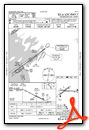
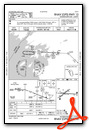
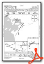
Instrument Approach Procedure (IAP) Charts


Nearby Airports with Instrument Procedures
| ID | Name | Heading / Distance | ||
|---|---|---|---|---|
 |
KGTB | Wheeler-Sack AAF Airport | 073° | 13.5 |
|
KFZY | Oswego County Airport | 202° | 41.7 |
|
KOGS | Ogdensburg International Airport | 029° | 47.8 |
|
KRME | Griffiss International Airport | 149° | 52.7 |
|
KSYR | Syracuse Hancock International Airport | 184° | 53.0 |
|
CYSH | Montague/Russ Beach Airport | 003° | 57.3 |
|
B16 | Whitfords Airport | 202° | 59.2 |
|
KPTD | Potsdam Municipal/Damon Field Airport | 047° | 61.8 |
|
CYTR | Trenton Airport | 277° | 65.7 |
|
KSDC | Williamson/Sodus Airport | 226° | 66.1 |
|
6B9 | Skaneateles Aero Drome Airport | 196° | 67.2 |
|
KVGC | Hamilton Municipal Airport | 163° | 71.7 |