Login
Register


7M5
Ozark/Franklin County Airport
Official FAA Data Effective 2025-11-27 0901Z
Chart Supplement

VFR Chart of 7M5
Sectional Charts at SkyVector.com
IFR Chart of 7M5
Enroute Charts at SkyVector.com
Location Information for 7M5
Coordinates: N35°30.64' / W93°50.36'Located 02 miles NW of Ozark, Arkansas on 46 acres of land. View all Airports in Arkansas.
Surveyed Elevation is 648 feet MSL.
Operations Data
|
|
Airport Communications
| RAZORBACK APPROACH: | 120.9 343.75 |
|---|---|
| RAZORBACK DEPARTURE: | 120.9 343.75 |
| UNICOM: | 122.800 |
| CTAF: | 122.800 |
| ATIS at FSM (27.8 W): | 124.775 |
| ASOS at FSM (27.8 W): | 479-649-2425 |
| ASOS at FYV (33.8 NW): | 119.575 479-442-5237 |
- APCH/DEP SVC PRVDD BY MEMPHIS ARTCC ON FREQS 128.475/377.15 (RUSSELLVILLE RCAG) WHEN RAZORBACK APCH CTL CLSD.
Nearby Navigation Aids
|
| ||||||||||||||||||||||||||||||||||||||||||||||||


Runway 04/22
| Dimensions: | 3302 x 75 feet / 1006 x 23 meters | |
|---|---|---|
| Surface: | Asphalt in Good Condition | |
| Weight Limits: | S-12 | |
| Edge Lighting: | Medium Intensity | |
| Runway 04 | Runway 22 | |
| Coordinates: | N35°30.46' / W93°50.60' | N35°30.83' / W93°50.11' |
| Elevation: | 606.0 | 648.0 |
| Traffic Pattern: | Left | Left |
| Runway Heading: | 47° True | 227° True |
| Markings: | Non-Precision Instrument in good condition. | Non-Precision Instrument in good condition. |
| Glide Slope Indicator | P2L (3.00° Glide Path Angle) | P2L (4.00° Glide Path Angle) RWY 22 PAPI UNUSBL BYD 2 DEG RIGHT OF CNTRLN. RWY 22 PAPI DOES NOT PRVD OBSTN CLNC BYD 4.0 NM FM THLD, UNUSBL BYD 4.0 NM. |
| Obstacles: | 5 ft Building 250 ft from runway | 35 ft Tree 800 ft from runway, 350 ft right of center |
Services Available
| Fuel: | 100LL (blue) |
|---|---|
| Transient Storage: | Tiedowns |
| Airframe Repair: | NOT AVAILABLE |
| Engine Repair: | NOT AVAILABLE |
| Bottled Oxygen: | NONE |
| Bulk Oxygen: | NONE |
Ownership Information
| Ownership: | Publicly owned | |
|---|---|---|
| Owner: | CITY OF OZARK-FRANKLIN CO | |
| PO BOX 196 | ||
| OZARK, AR 72949 | ||
| 479-667-4726 | COUNTY JUDGE. | |
| Manager: | J. C. SMITH | |
| P.O. BOX 262 | ||
| OZARK, AR 72949 | ||
| 479-667-7618 | ||
Other Remarks
- THIS AIRPORT HAS BEEN SURVEYED BY THE NATIONAL GEODETIC SURVEY.
- USE EXTRM CTN, WILDLIFE MAY BE ON FLD.
- FOR CD CTC RAZORBACK APCH AT 479-649-2416, WHEN APCH CLSD CTC MEMPHIS ARTCC AT 901-368-8453/8449.
- 0LL SELF SERVICE FUEL AVBL 24 HRS WITH CREDIT CARD.
- DUSK-DAWN. ACTVT MIRL RY 04/22, PAPI RYS 4 &22 - CTAF.
Weather Minimums

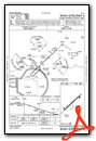
Instrument Approach Procedure (IAP) Charts
Nearby Airports with Instrument Procedures
| ID | Name | Heading / Distance | ||
|---|---|---|---|---|
 |
H35 | Clarksville Municipal Airport | 096° | 20.3 |
|
KFSM | Fort Smith Regional Airport | 248° | 27.9 |
|
32A | Danville Municipal Airport | 141° | 32.4 |
|
KFYV | Drake Field Airport | 331° | 33.7 |
|
H34 | Huntsville Municipal Airport | 006° | 34.3 |
|
KRUE | Russellville Regional Airport | 112° | 39.6 |
|
KASG | Springdale Municipal Airport | 341° | 42.2 |
|
KJSV | Sallisaw Municipal Airport | 265° | 47.4 |
|
KRKR | Robert S Kerr Airport | 232° | 48.3 |
|
KMPJ | Petit Jean Park Airport | 115° | 50.8 |
|
KXNA | Northwest Arkansas Ntl Airport | 333° | 51.5 |
|
KSLG | Smith Field Airport | 322° | 51.7 |
Airport Images
Do you have a recent image of this airport? Upload it here!


