Login
Register


MVM
Machias Valley Airport
Official FAA Data Effective 2026-02-19 0901Z
Chart Supplement

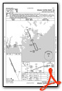
VFR Chart of KMVM
Sectional Charts at SkyVector.com
IFR Chart of KMVM
Enroute Charts at SkyVector.com
Location Information for KMVM
Coordinates: N44°42.19' / W67°28.72'Located 01 miles SW of Machias, Maine on 30 acres of land. View all Airports in Maine.
Surveyed Elevation is 96 feet MSL.
Operations Data
|
|
Airport Communications
| AWOS-AV: | 122.8 Tel. 207-255-2511 |
|---|---|
| UNICOM: | 122.800 |
| CTAF: | 122.800 |
| AWOS-AV at EPM (23.4 NE): | 122.8 207-853-0682 |
| AWOS-AV at PNN (30.1 N): | 122.7 |
| AWOS-3PT at BHB (40.7 W): | 118.35 207-667-7364 |
- APCH/DEP SVC PRVDD BY BOSTON ARTCC ON FREQ 124.25/290.50 (BANGOR RCAG).
- CLNC DEL THRU BANGOR RADIO (BGR) ON FREQ 122.5 (BUCKS HARBOR RCO).
Nearby Navigation Aids
|
| ||||||||||||||||||||||||||||||||||||||||||||||||


Runway 18/36
| Dimensions: | 2880 x 60 feet / 878 x 18 meters | |
|---|---|---|
| Surface: | Asphalt in Excellent Condition | |
| Weight Limits: | S-12 | |
| Edge Lighting: | Medium Intensity | |
| Runway 18 | Runway 36 | |
| Coordinates: | N44°42.40' / W67°28.85' | N44°41.97' / W67°28.59' |
| Elevation: | 96.2 | 70.2 |
| Traffic Pattern: | Left | Left |
| Runway Heading: | 157° True | 337° True |
| Markings: | Non-Precision Instrument in good condition. | Non-Precision Instrument in good condition. |
| REIL: | Yes | |
| Obstacles: | 53 ft Pole 999 ft from runway, 339 ft right of center | |
Services Available
| Fuel: | 100LL (blue) |
|---|---|
| Transient Storage: | Tiedowns |
| Airframe Repair: | NONE |
| Engine Repair: | NONE |
| Bottled Oxygen: | NONE |
| Bulk Oxygen: | NONE |
Ownership Information
| Ownership: | Publicly owned | |
|---|---|---|
| Owner: | TOWN OF MACHIAS | |
| PO BOX 418 | ||
| MACHIAS, ME 04654 | ||
| 207-255-8683 | ||
| Manager: | BILL KITCHEN | TOWN MGR EMAIL: TOWNMANAGER@MACHIASME.ORG. |
| TOWN OFFICES, PO BOX 418 | ||
| MACHIAS, ME 04654 | ||
| 207-271-0808 | ||
Other Remarks
- DEER & WILDLIFE ON & INVOF ARPT.
- FOR CD CTC BOSTON ARTCC AT 603-879-6859.
- 0LL 24 HR SELF SVC WITH MAJOR CREDIT CARD.
- ACTVT REIL RWY 36; MIRL RWY 18/36 - CTAF.
Weather Minimums

Instrument Approach Procedure (IAP) Charts
Nearby Airports with Instrument Procedures
| ID | Name | Heading / Distance | ||
|---|---|---|---|---|
 |
43B | Deblois Flight Strip Airport | 273° | 22.0 |
|
KEPM | Eastport Municipal Airport | 057° | 23.5 |
|
KPNN | Princeton Municipal Airport | 353° | 30.1 |
|
KBHB | Hancock County/Bar Harbor Airport | 248° | 40.8 |
|
KOLD | Dewitt Field/Old Town Municipal Airport | 286° | 53.2 |
|
KBGR | Bangor International Airport | 276° | 58.0 |
|
KLRG | Lincoln Regional Airport | 311° | 59.8 |
|
KBST | Belfast Municipal Airport | 255° | 68.1 |
|
KMLT | Millinocket Municipal Airport | 318° | 76.4 |
|
CYSJ | St John Airport | 060° | 77.0 |
|
1B0 | Dexter Regional Airport | 284° | 77.2 |
|
KRKD | Knox County Regional Airport | 241° | 79.7 |
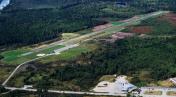
Airport Images

By: len.emery
By: len.emery


