Login
Register


T69
Sinton Airport
Official FAA Data Effective 2026-01-22 0901Z
Chart Supplement

VFR Chart of T69
Sectional Charts at SkyVector.com
IFR Chart of T69
Enroute Charts at SkyVector.com
Location Information for T69
Coordinates: N28°2.31' / W97°32.55'Located 02 miles W of Sinton, Texas on 186 acres of land. View all Airports in Texas.
Surveyed Elevation is 47 feet MSL.
Operations Data
|
|
Airport Communications
| AWOS-3: | 118.25 Tel. 361-364-1844 |
|---|---|
| CORPUS APPROACH: | 120.9 348.725 |
| CORPUS DEPARTURE: | 120.9 348.725 |
| CTAF: | 122.800 |
| UNICOM: | 122.800 |
| ASOS at CRP (16.0 S): | 361-267-5360 |
| ATIS at CRP (16.1 S): | 126.8 |
| AWOS-3 at RBO (17.4 SW): | 118.175 361-767-1982 |
Nearby Navigation Aids
|
| ||||||||||||||||||||||||||||||||||||


Runway 14/32
| Dimensions: | 4323 x 55 feet / 1318 x 17 meters | |
|---|---|---|
| Surface: | Asphalt in Fair Condition | |
| Weight Limits: | S-8 | |
| Edge Lighting: | Medium Intensity | |
| Runway 14 | Runway 32 | |
| Coordinates: | N28°2.65' / W97°32.77' | N28°2.06' / W97°32.32' |
| Elevation: | 46.2 | 46.5 |
| Traffic Pattern: | Left | Left |
| Runway Heading: | 146° True | 326° True |
| Displaced Threshold: | 250 Feet | 400 Feet |
| Markings: | Non-Precision Instrument in good condition. | Non-Precision Instrument in good condition. |
| Glide Slope Indicator | P2L (3.00° Glide Path Angle) | P2L (3.00° Glide Path Angle) |
| REIL: | Yes | Yes |
| Obstacles: | 20 ft Road 201 ft from runway, 195 ft left of center -25 FT CREEK BED 25 FT FM THR ACRS CNTRLN. APCH RATIO 17:1 TO DSPLCD THR OVR 17 FT RD, 294 FT DSTC, 295 FT L. 5 FT FENCE, 0 FT DSTC 220 FT L. |
15 ft Road 200 ft from runway, 180 ft right of center APCH RATIO 19:1 TO DSPLCD THR OVR 15 FT RD, 285 FT DSTC, 293 FT R. 3 FT FENCE AND 15 FT RD 0 FT DSTC, 110 FT L. |
Runway 03/21
RWY 03/21 CLSD INDEFLY. | ||
| Dimensions: | 3100 x 50 feet / 945 x 15 meters | |
|---|---|---|
| Surface: | Turf in Failed Condition RWY NOT MNTND, NOT INSPD. UNA TO DTRM EXACT LCTN OF RWY. | |
| Runway 03 | Runway 21 | |
| Coordinates: | N28°2.06' / W97°32.74' | N28°2.45' / W97°32.37' |
| Elevation: | 47.0 | 47.0 |
| Runway Heading: | 41° True | 221° True |
| Obstacles: | 15 ft Road 78 ft from runway | 35 ft Power Line 400 ft from runway |
Services Available
| Fuel: | 100LL (blue), Jet A+ |
|---|---|
| Transient Storage: | Tiedowns |
| Airframe Repair: | MAJOR |
| Engine Repair: | MAJOR |
| Bottled Oxygen: | NONE |
| Bulk Oxygen: | NONE |
| Other Services: | PILOT INSTRUCTION,AIRCRAFT RENTAL |
Ownership Information
| Ownership: | Publicly owned | |
|---|---|---|
| Owner: | SAN PATRICIO COUNTY | |
| SAN PATRICIO COUNTY COURTHOUSE, 1301 E SINTON | ||
| SINTON, TX 78387 | ||
| 361-364-9300 | ||
| Manager: | GARY LEE DAVIS | |
| 3141 FM 3512 | ||
| ARANSAS PASS, TX 78336 | ||
| 361-226-0112 | GDAVIS@SANPATRICIOCOUNTYTX.GOV | |
Other Remarks
- FOR CD CTC CORPUS CHRISTI APCH AT 361-299-4230.
- 0LL FOR FUEL OR SVC CALL 361-364-3200. AFT HRS CALL 361-548-1483 OR 361-364-2251.
- ACTVT REIL RWY 14 & 32; MIRL RWY 14/32 - CTAF.
Weather Minimums

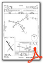
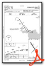
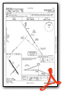
Instrument Approach Procedure (IAP) Charts
Nearby Airports with Instrument Procedures
| ID | Name | Heading / Distance | ||
|---|---|---|---|---|
 |
KCRP | Corpus Christi International Airport | 172° | 16.1 |
|
KRBO | Nueces County Airport | 206° | 17.4 |
|
KTFP | Ingleside Regional Airport | 113° | 19.1 |
|
TX2 | Chase Field Industrial Airport | 341° | 20.4 |
|
KBEA | Beeville Municipal Airport | 325° | 23.6 |
|
KNGP | Corpus Christi NAS (Truax Field) Airport | 147° | 24.7 |
|
KRKP | Aransas County Airport | 083° | 26.6 |
|
KRAS | Mustang Beach Airport | 119° | 27.7 |
|
KNOG | Orange Grove Nalf Airport | 252° | 27.9 |
|
KALI | Alice International Airport | 235° | 31.3 |
|
KNQI | Kingsville NAS Airport | 203° | 34.9 |
|
8T6 | Live Oak County Airport | 302° | 36.1 |
Airport Images
Do you have a recent image of this airport? Upload it here!


