Login
Register


GVQ
Genesee County Airport
Official FAA Data Effective 2026-01-22 0901Z
Chart Supplement

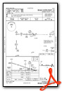
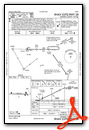
VFR Chart of KGVQ
Sectional Charts at SkyVector.com
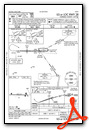
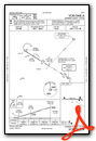
IFR Chart of KGVQ
Enroute Charts at SkyVector.com
Location Information for KGVQ
Coordinates: N43°1.91' / W78°10.18'Located 02 miles N of Batavia, New York on 326 acres of land. View all Airports in New York.
Surveyed Elevation is 913 feet MSL.
Operations Data
|
|
Airport Communications
| AWOS-3PT: | 127.525 Tel. 585-343-6369 |
|---|---|
| ROCHESTER APPROACH: | 123.7 322.3 |
| ROCHESTER DEPARTURE: | 123.7 322.3 |
| CLEARANCE DELIVERY: | 121.8 |
| CTAF: | 122.700 |
| UNICOM: | 122.700 |
| AWOS-2 at 01G (18.2 S): | 118.525 585-237-0235 |
| ASOS at ROC (22.4 E): | 124.825 585-205-7835 |
| ATIS at ROC (22.5 E): | 124.825 |
Nearby Navigation Aids
|
| ||||||||||||||||||||||||||||||||||||||||||||||||||||||||||||


Runway 10/28
| Dimensions: | 5499 x 100 feet / 1676 x 30 meters | |
|---|---|---|
| Surface: | Asphalt / Grooved in Fair Condition | |
| Weight Limits: | S-21, D-33 | |
| Edge Lighting: | High Intensity | |
| Runway 10 | Runway 28 | |
| Coordinates: | N43°1.91' / W78°10.80' | N43°1.90' / W78°9.56' |
| Elevation: | 911.6 | 910.6 |
| Traffic Pattern: | Left | Left |
| Runway Heading: | 91° True | 271° True |
| Markings: | Non-Precision Instrument in fair condition. | Precision Instrument in fair condition. |
| Glide Slope Indicator | P2L (3.00° Glide Path Angle) | P2L (3.00° Glide Path Angle) |
| Approach Lights: | MALSR 1,400 Foot Medium-intensity Approach Lighting System with runway alignment indicator lights. | |
| REIL: | Yes | |
| Obstacles: | 8 ft Fence 200 ft from runway, 460 ft right of center 8 FT FENCE, 0-199 FT DSTC, 460 FT R. |
|
Services Available
| Fuel: | 100LL (blue), Jet A-1+ |
|---|---|
| Transient Storage: | Hangars,Tiedowns |
| Airframe Repair: | MAJOR |
| Engine Repair: | MAJOR |
| Bottled Oxygen: | NONE |
| Bulk Oxygen: | HIGH |
| Other Services: | AIR FREIGHT SERVICES,CROP DUSTING SERVICES,AIR AMBULANCE SERVICES,CHARTER SERVICE,PILOT INSTRUCTION,AIRCRAFT RENTAL |
Ownership Information
| Ownership: | Publicly owned | |
|---|---|---|
| Owner: | GENESEE COUNTY | |
| GENESEE CO. SUPT. OF HWY., 153 CEDAR STREET | ||
| BATAVIA, NY 14020 | ||
| 585-344-8508 | ||
| Manager: | JASON LONG | |
| 4701 E. SAILE DRIVE | ||
| BATAVIA, NY 14020 | ||
| 585-344-8532 | ||
Other Remarks
- THIS AIRPORT HAS BEEN SURVEYED BY THE NATIONAL GEODETIC SURVEY.
- RWY 10: 5 FT BERM 220 FT N, 1600-2200 FT E OF RWY 10 END.
- FOR CD CTC CLEVELAND ARTCC AT 440-774-0490.
- ACTVT MALSR RWY 28; REIL RWY 10; PAPI RWY 10 & 28; HIRL RWY 10/28 - CTAF.
Weather Minimums
Instrument Approach Procedure (IAP) Charts
Nearby Airports with Instrument Procedures
| ID | Name | Heading / Distance | ||
|---|---|---|---|---|
 |
9G6 | Pine Hill Airport | 331° | 9.7 |
|
5G0 | Le Roy Airport | 106° | 10.8 |
|
9G3 | Akron/Jesson Field Airport | 267° | 13.8 |
|
7G0 | Ledgedale Airpark Airport | 051° | 14.3 |
|
KBQR | Buffalo-Lancaster Regional Airport | 251° | 20.6 |
|
KROC | Frederick Douglass/Greater Rochester International Airport | 076° | 22.5 |
|
KBUF | Buffalo Niagara International Airport | 257° | 25.3 |
|
9G0 | Buffalo Airfield Airport | 247° | 26.2 |
|
KDSV | Dansville Municipal Airport | 143° | 34.2 |
|
KIAG | Niagara Falls International Airport | 277° | 34.5 |
|
KIUA | Canandaigua Airport | 100° | 37.9 |
|
KHTF | Hornell Municipal Airport | 150° | 44.5 |
Airport Images
Do you have a recent image of this airport? Upload it here!


Comments
fuel prices
the fuel prices for geneseo kgvq airport is 4.70 per gallon
Carlos Vera