Login
Register


5G0
Le Roy Airport
Official FAA Data Effective 2026-01-22 0901Z
Chart Supplement

VFR Chart of 5G0
Sectional Charts at SkyVector.com
IFR Chart of 5G0
Enroute Charts at SkyVector.com
Location Information for 5G0
Coordinates: N42°58.88' / W77°56.11'Located 02 miles E of Le Roy, New York on 83 acres of land. View all Airports in New York.
Surveyed Elevation is 780 feet MSL.
Operations Data
|
|
Airport Communications
| ROCHESTER APPROACH: | 123.7 322.3 |
|---|---|
| ROCHESTER DEPARTURE: | 123.7 322.3 |
| UNICOM: | 122.800 |
| CTAF: | 122.800 |
| AWOS-3PT at GVQ (10.6 W): | 127.525 585-343-6369 |
| ASOS at ROC (14.2 NE): | 124.825 585-205-7835 |
| ATIS at ROC (14.2 NE): | 124.825 |
Nearby Navigation Aids
|
| ||||||||||||||||||||||||||||||||||||||||||||||||||||||||||||


Runway 10/28
| Dimensions: | 3854 x 60 feet / 1175 x 18 meters | |
|---|---|---|
| Surface: | Asphalt in Good Condition | |
| Weight Limits: | S-12 | |
| Edge Lighting: | Medium Intensity | |
| Runway 10 | Runway 28 | |
| Coordinates: | N42°58.89' / W77°56.55' | N42°58.86' / W77°55.68' |
| Elevation: | 780.0 | 778.3 |
| Traffic Pattern: | Left | Left |
| Runway Heading: | 93° True | 273° True |
| Markings: | Non-Precision Instrument in fair condition. | Non-Precision Instrument in fair condition. |
| Glide Slope Indicator | P2L (3.00° Glide Path Angle) | P2L (3.50° Glide Path Angle) |
| REIL: | Yes | Yes |
| Obstacles: | 40 ft Tree 214 ft from runway, 220 ft left of center 30 FT TREES; 320 FT DTSC, 100 FT RIGHT. 8 FT FENCE; 0-199 FT DSTC, 94 FT LEFT. |
8 ft Fence 201 ft from runway, 100 ft right of center 8 FT FENCE; 0-199 FT DSTC, 100 FT RIGHT. |
Services Available
| Fuel: | 100LL (blue) |
|---|---|
| Transient Storage: | Hangars,Tiedowns |
| Airframe Repair: | MINOR |
| Engine Repair: | MINOR |
| Bottled Oxygen: | NONE |
| Bulk Oxygen: | NONE |
| Other Services: | PILOT INSTRUCTION,AIRCRAFT RENTAL,AIRCRAFT SALES |
Ownership Information
| Ownership: | Privately Owned | |
|---|---|---|
| Owner: | LEROY AVIATION SERVICES INC | |
| 8267 EAST MAIN ROAD | ||
| LE ROY, NY 14482 | ||
| 585-768-4560 | ||
| Manager: | RAY DETOR | |
| 283 WESTMINSTER ROAD | ||
| ROCHESTER, NY 14607-3229 | ||
| 585-259-9308 | ||
Other Remarks
- DEER ON AND INVOF ARPT.
- FOR CD CTC CLEVELAND ARTCC AT 440-774-0490.
- SS-SR, ACTVT REIL RWY 10 & 28; PAPI RWY 10 & 28; MIRL RWY 10/28 - CTAF.
Weather Minimums
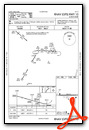
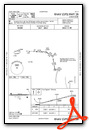
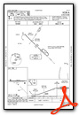
Instrument Approach Procedure (IAP) Charts
Nearby Airports with Instrument Procedures
| ID | Name | Heading / Distance | ||
|---|---|---|---|---|
 |
KGVQ | Genesee County Airport | 286° | 10.8 |
|
7G0 | Ledgedale Airpark Airport | 004° | 12.0 |
|
KROC | Frederick Douglass/Greater Rochester International Airport | 054° | 14.2 |
|
9G6 | Pine Hill Airport | 307° | 18.9 |
|
9G3 | Akron/Jesson Field Airport | 275° | 24.2 |
|
KDSV | Dansville Municipal Airport | 158° | 26.5 |
|
KIUA | Canandaigua Airport | 098° | 27.2 |
|
KBQR | Buffalo-Lancaster Regional Airport | 263° | 30.0 |
|
KBUF | Buffalo Niagara International Airport | 266° | 35.1 |
|
9G0 | Buffalo Airfield Airport | 258° | 35.2 |
|
KHTF | Hornell Municipal Airport | 162° | 37.6 |
|
KSDC | Williamson/Sodus Airport | 066° | 38.9 |
Airport Images
Do you have a recent image of this airport? Upload it here!


Comments
Great little airport. New
Great little airport. New asphalt surface. Easy in/out for a self-serve fuel stop. Owner was "way beyond" helpful.