
Login
Register


TKX
Kennett Memorial Airport
Official FAA Data Effective 2026-02-19 0901Z
Chart Supplement
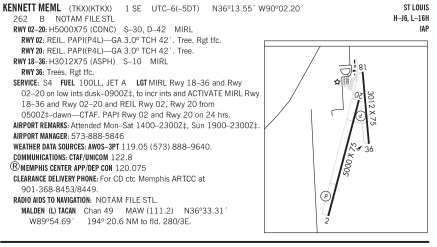
VFR Chart of KTKX
Sectional Charts at SkyVector.com
IFR Chart of KTKX
Enroute Charts at SkyVector.com
Location Information for KTKX
Coordinates: N36°13.55' / W90°2.20'Located 01 miles SE of Kennett, Missouri on 337 acres of land. View all Airports in Missouri.
Surveyed Elevation is 261 feet MSL.
Operations Data
|
|
Airport Communications
| AWOS-3PT: | 119.05 Tel. 573-888-9640 |
|---|---|
| CTAF: | 122.800 |
| UNICOM: | 122.800 |
| ASOS at HKA (19.9 SE): | 135.025 870-763-8206 |
| AWOS-3PT at MAW (22.3 N): | 119.825 573-276-9970 |
| AWOS-3T at 4M9 (31.6 W): | 118.325 870-857-9702 |
- APCH/DEP SVC PRVDD BY MEMPHIS ARTCC FREQS 120.075/289.4 (WALNUT RIDGE RCAG).
Nearby Navigation Aids
|
| ||||||||||||||||||||||||||||||||||||||||||||||||||||||||||||


Runway 02/20
| Dimensions: | 5000 x 75 feet / 1524 x 23 meters | |
|---|---|---|
| Surface: | Concrete in Good Condition | |
| Weight Limits: | S-30, D-42 | |
| Edge Lighting: | Medium Intensity | |
| Runway 02 | Runway 20 | |
| Coordinates: | N36°13.03' / W90°2.43' | N36°13.82' / W90°2.12' |
| Elevation: | 258.5 | 258.3 |
| Traffic Pattern: | Right | |
| Runway Heading: | 18° True | 198° True |
| Markings: | Non-Precision Instrument in good condition. | Non-Precision Instrument in good condition. |
| Glide Slope Indicator | P4L (3.00° Glide Path Angle) | P4L (3.00° Glide Path Angle) |
| REIL: | Yes | Yes |
| Obstacles: | 43 ft Tree 1065 ft from runway, 300 ft left of center | 45 ft Tree 1560 ft from runway, 390 ft left of center |
Runway 18/36
| Dimensions: | 3012 x 75 feet / 918 x 23 meters | |
|---|---|---|
| Surface: | Asphalt in Good Condition | |
| Weight Limits: | S-10 | |
| Edge Lighting: | Medium Intensity | |
| Runway 18 | Runway 36 | |
| Coordinates: | N36°14.01' / W90°2.07' | N36°13.51' / W90°2.06' |
| Elevation: | 260.1 | 257.8 |
| Traffic Pattern: | Right | |
| Runway Heading: | 179° True | 359° True |
| Markings: | Basic in good condition. | Basic in good condition. |
| Obstacles: | 33 ft Trees 543 ft from runway, 140 ft right of center | |
Services Available
| Fuel: | 100LL (blue), Jet-A |
|---|---|
| Transient Storage: | Tiedowns |
| Airframe Repair: | MAJOR |
| Engine Repair: | MAJOR |
| Bottled Oxygen: | NONE |
| Bulk Oxygen: | NONE |
| Other Services: | AIRCRAFT RENTAL |
Ownership Information
| Ownership: | Publicly owned | |
|---|---|---|
| Owner: | CITY OF KENNETT | |
| 200 CEDAR ST. | ||
| KENNETT, MO 63857 | ||
| 573-888-9001 | ||
| Manager: | SAMMY JEWELL | |
| PO BOX 623 | ||
| KENNETT, MO 63857 | ||
| 573-888-5846 | ||
Other Remarks
- AIRPORT PHONE (573) 888-1339.
- FOR CD CTC MEMPHIS ARTCC AT 901-368-8453/8449.
- MIRL RYS 18/36 & 02/20 ON LOW INTST DUSK-0300; TO INCR INTST & ACTVT MIRL RYS 18/36 & 02/20 & REIL RYS 02; 20 FM 2300-DAWN - CTAF. PAPI RYS 02 & 20 ON 24 HRS.
Weather Minimums

Instrument Approach Procedure (IAP) Charts


Nearby Airports with Instrument Procedures
| ID | Name | Heading / Distance | ||
|---|---|---|---|---|
 |
M12 | Steele Municipal Airport | 132° | 11.6 |
|
M85 | Gideon Memorial Airport | 026° | 14.6 |
|
KBYH | Arkansas International Airport | 163° | 16.3 |
|
M05 | Caruthersville Memorial Airport | 100° | 17.8 |
|
KHKA | Blytheville Municipal Airport | 149° | 19.8 |
|
KMXA | Manila Municipal Airport | 196° | 20.7 |
|
KMAW | Malden Regional Airport | 005° | 22.4 |
|
KPGR | Kirk Field Airport | 247° | 24.9 |
|
KEIW | County Memorial Airport | 048° | 28.1 |
|
4M9 | Corning Municipal Airport | 290° | 31.5 |
|
7M4 | Osceola Municipal Airport | 177° | 32.1 |
|
KDXE | Dexter Municipal Airport | 007° | 33.3 |
Airport Images
Do you have a recent image of this airport? Upload it here!



Comments
Great Place to Stop
Stopped in for fuel and to stretch are legs on 11-22-15 during our Ohio to Texas trip. Great building and facility. Had a issue with card reader for fuel. Call FBO emergency contact, David, and he came in to help us out. Very curtious and professional, we appriciate all the help. Great price for fuel and great place to stop. James and Cathy
James Spradling