Login
Register


CKN
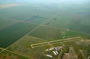
Crookston Municipal/Kirkwood Field Airport
Official FAA Data Effective 2025-11-27 0901Z
Chart Supplement

VFR Chart of KCKN
Sectional Charts at SkyVector.com
IFR Chart of KCKN
Enroute Charts at SkyVector.com
Location Information for KCKN
Coordinates: N47°50.45' / W96°37.33'Located 04 miles N of Crookston, Minnesota on 633 acres of land. View all Airports in Minnesota.
Surveyed Elevation is 896 feet MSL.
Operations Data
|
|
Airport Communications
| AWOS-3: | 126.425 Tel. 218-281-3018 |
|---|---|
| GRAND FORKS APPROACH: | 118.1 318.1 |
| GRAND FORKS DEPARTURE: | 118.1 318.1 |
| UNICOM: | 122.700 |
| CTAF: | 122.700 |
| AWOS-3PT at TVF (22.1 NE): | 119.025 218-681-1918 |
| ATIS at GFK (23.2 W): | 119.4 |
| ASOS at GFK (23.4 W): | 701-772-3486 |
- APCH/DEP SVC PRVDD BY MINNEAPOLIS ARTCC (ZMP) ON FREQ 132.15/269.6 (GRAND FORKS RCAG) WHEN GRAND FORKS (RDR) APCH CTL CLSD.
Nearby Navigation Aids
|
| ||||||||||||||||||||||||||||||||||||||||||||||||


Runway 13/31
| Dimensions: | 4300 x 75 feet / 1311 x 23 meters | |
|---|---|---|
| Surface: | Asphalt in Good Condition | |
| Weight Limits: | S-11, D-16 | |
| Edge Lighting: | Medium Intensity | |
| Runway 13 | Runway 31 | |
| Coordinates: | N47°50.66' / W96°37.71' | N47°50.16' / W96°36.96' |
| Elevation: | 894.7 | 896.7 |
| Traffic Pattern: | Left | Left |
| Runway Heading: | 135° True | 315° True |
| Markings: | Non-Precision Instrument in good condition. | Non-Precision Instrument in good condition. |
| Glide Slope Indicator | P4L (3.00° Glide Path Angle) | P4R (3.00° Glide Path Angle) |
| REIL: | Yes | Yes |
Runway 17/35
NOT PLOWED WINTER MONTHS. | ||
| Dimensions: | 2977 x 200 feet / 907 x 61 meters | |
|---|---|---|
| Surface: | Turf in Good Condition | |
| Runway 17 | Runway 35 | |
| Coordinates: | N47°50.75' / W96°37.33' | N47°50.26' / W96°37.33' |
| Elevation: | 894.9 | 892.4 |
| Traffic Pattern: | Left | Left |
| Runway Heading: | 180° True | 0 |
| Markings: | Non-Standard in good condition. | Non-Standard in good condition. |
Services Available
| Fuel: | 100LL (blue), Jet-A |
|---|---|
| Transient Storage: | Hangars,Tiedowns |
| Airframe Repair: | MAJOR |
| Engine Repair: | MAJOR |
| Bottled Oxygen: | NONE |
| Bulk Oxygen: | NONE |
| Other Services: | CROP DUSTING SERVICES,PILOT INSTRUCTION,AIRCRAFT RENTAL,AIRCRAFT SALES |
Ownership Information
| Ownership: | Publicly owned | |
|---|---|---|
| Owner: | CITY OF CROOKSTON | |
| 124 N BROADWAY | ||
| CROOKSTON, MN 56716-1731 | ||
| 218-281-4503 | ||
| Manager: | LOWELL MILLER | |
| 26305 AIRPORT RD SW | ||
| CROOKSTON, MN 56716-9004 | ||
| 218-281-2625 | ||
Other Remarks
- FOR CD CTC MINNEAPOLIS ARTCC AT 651-463-5588.
- CALM WIND RWY.
- YELLOW CONES.
- YELLOW CONES.
- 0LL FUEL AVBL H24 VIA CREDIT CARD.
- ACTVT REIL RWY 13 & 31; PAPI RWY 13; MIRL RWY 13/31 - CTAF. PAPI RWY 31 OPR CONSLY.
Weather Minimums

Instrument Approach Procedure (IAP) Charts

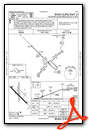
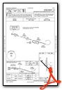
Nearby Airports with Instrument Procedures
| ID | Name | Heading / Distance | ||
|---|---|---|---|---|
 |
D37 | Warren Municipal Airport | 350° | 21.3 |
|
D14 | Fertile Municipal Airport | 142° | 21.9 |
|
KTVF | Thief River Falls Regional Airport | 052° | 22.2 |
|
KGFK | Grand Forks International Airport | 286° | 23.3 |
|
KRDR | Grand Forks AFB Airport | 283° | 32.3 |
|
3H4 | Hillsboro Municipal Airport | 211° | 33.9 |
|
D00 | Norman County Ada/Twin Valley Airport | 165° | 36.0 |
|
KFSE | Fosston Municipal/Anderson Field Airport | 113° | 37.5 |
|
4V4 | Northwood Municipal/Vince Field Airport | 260° | 39.8 |
|
3N8 | Mahnomen County Airport | 140° | 44.8 |
|
KGAF | Hutson Field Airport | 318° | 45.3 |
|
KFAR | Hector International Airport | 188° | 55.8 |