Login
Register


CRE
Grand Strand Airport
Official FAA Data Effective 2025-11-27 0901Z
Chart Supplement

KCRE Airport Diagram

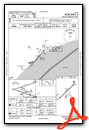
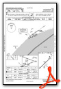
VFR Chart of KCRE
Sectional Charts at SkyVector.com
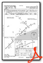
IFR Chart of KCRE
Enroute Charts at SkyVector.com
Location Information for KCRE
Coordinates: N33°48.71' / W78°43.44'Located 01 miles NW of North Myrtle Beach, South Carolina on 427 acres of land. View all Airports in South Carolina.
Surveyed Elevation is 31 feet MSL.
Operations Data
|
|
Airport Communications
| ATIS: | 119.625 |
|---|---|
| ASOS: | 119.625 Tel. 843-361-2802 |
| STRAND TOWER: | 124.6 257.6 |
| STRAND GROUND: | 121.8 257.6 |
| MYRTLE BEACH APPROACH: | 119.2 350.3 |
| MYRTLE BEACH DEPARTURE: | 119.2 350.3 |
| CLEARANCE DELIVERY: | 121.8 |
| UNICOM: | 122.950 |
| CTAF: | 124.600 |
| ATIS at MYR (12.9 SW): | 123.925 |
| AWOS-3PT at MYR (13.2 SW): | 123.925 843-238-0335 |
| AWOS-3 at HYW (20.1 W): | 119.525 843-397-8046 |
- APCH/DEP SVC PRVDD BY JACKSONVILLE ARTCC ON FREQS 134.375/317.550 (MYRTLE BEACH RCAG) WHEN APCH CTL CLSD.
Nearby Navigation Aids
|
| ||||||||||||||||||||||||||||||||||||||||||||||||||||||||||||


Runway 05/23
| Dimensions: | 5997 x 100 feet / 1828 x 30 meters | |
|---|---|---|
| Surface: | Asphalt in Good Condition | |
| Weight Limits: | 29 /F/B/X/T, S-76, D-112 | |
| Edge Lighting: | High Intensity | |
| Runway 05 | Runway 23 | |
| Coordinates: | N33°48.36' / W78°43.86' | N33°49.05' / W78°43.01' |
| Elevation: | 31.6 | 29.2 |
| Traffic Pattern: | Left | Right |
| Runway Heading: | 46° True | 226° True |
| Markings: | Precision Instrument in good condition. | Precision Instrument in good condition. |
| Glide Slope Indicator | P2L (3.00° Glide Path Angle) | P2R (2.98° Glide Path Angle) |
| Approach Lights: | MALSR 1,400 Foot Medium-intensity Approach Lighting System with runway alignment indicator lights. | |
| REIL: | Yes | |
| Obstacles: | 59 ft Trees 1434 ft from runway, 273 ft right of center | 98 ft Trees 3450 ft from runway, 672 ft left of center |
Services Available
| Fuel: | 100LL (blue), Jet-A |
|---|---|
| Transient Storage: | Hangars,Tiedowns |
| Airframe Repair: | NONE |
| Engine Repair: | NONE |
| Bottled Oxygen: | NONE |
| Bulk Oxygen: | NONE |
| Other Services: | CHARTER SERVICE,PILOT INSTRUCTION,AIRCRAFT RENTAL |
Ownership Information
| Ownership: | Publicly owned | |
|---|---|---|
| Owner: | HORRY COUNTY | |
| PO BOX 1236 | ||
| CONWAY, SC 29526 | ||
| 843-448-1580 | ||
| Manager: | JUDI OLMSTEAD | |
| 1100 JETPORT ROAD | ||
| MYRTLE BEACH, SC 29577 | ||
| 843-448-1580 | ||
Other Remarks
- EXTENSIVE BANNER TOW OPERATIONS FM ARPT ALONG COAST LINE 10 NM NE TO 20 NM SW.
- GULLS ON & INVOF ARPT.
- FOR CD WHEN ATCT CLSD CTC MYRTLE BEACH APCH AT 843-477-2727/2704. WHEN MYR APCH CLSD CTC JACKSONVILLE ARTCC AT 904-845-1592.
- AFTER 0000 ACTVT HIRL RY 05/23; REIL RY 05 AND MALSR RY 23 - CTAF.
Weather Minimums
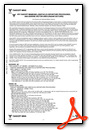
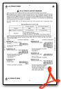
Instrument Approach Procedure (IAP) Charts


Nearby Airports with Instrument Procedures
| ID | Name | Heading / Distance | ||
|---|---|---|---|---|
 |
KMYR | Myrtle Beach International Airport | 232° | 12.9 |
|
5J9 | Twin City Airport | 337° | 18.0 |
|
KHYW | Conway-Horry County Airport | 272° | 19.9 |
|
KCPC | Columbus County Regional Airport | 000° | 27.6 |
|
KSUT | Cape Fear Regional Jetport/Howie Franklin Field Airport | 077° | 33.3 |
|
KMAO | Marion County Airport | 306° | 37.7 |
|
KGGE | Georgetown County Airport | 225° | 42.3 |
|
KPHH | Robert F Swinnie Airport | 242° | 45.6 |
|
KEYF | Curtis L Brown Jr Field Airport | 008° | 47.9 |
|
KILM | Wilmington International Airport | 055° | 49.3 |
|
KDLC | Dillon County Airport | 320° | 49.9 |
|
KLBT | Lumberton Regional Airport | 340° | 50.6 |
Airport Images
Do you have a recent image of this airport? Upload it here!


Comments
Beach Aviation Services phone number correction
Beach Aviation Services phone number is 843-848-7400
Scott R Copeland