Login
Register


MAO
Marion County Airport
Official FAA Data Effective 2026-02-19 0901Z
Chart Supplement

VFR Chart of KMAO
Sectional Charts at SkyVector.com
IFR Chart of KMAO
Enroute Charts at SkyVector.com
Location Information for KMAO
Coordinates: N34°10.87' / W79°20.08'Located 03 miles E of Marion, South Carolina on 130 acres of land. View all Airports in South Carolina.
Surveyed Elevation is 92 feet MSL.
Operations Data
|
|
Airport Communications
| AWOS-3PT: | 119.875 Tel. 843-423-4231 |
|---|---|
| FLORENCE APPROACH: | 135.25 316.15 |
| FLORENCE DEPARTURE: | 135.25 316.15 |
| CTAF: | 122.800 |
| UNICOM: | 122.800 |
| ASOS at FLO (19.3 W): | 843-665-1306 |
| ATIS at FLO (19.3 W): | 123.625 |
| AWOS-3 at HYW (23.7 SE): | 119.525 843-397-8046 |
- APCH/DEP SVC PRVDD BY JACKSONVILLE ARTCC ON FREQS 133.45/306.3 (FLORENCE RCAG) WHEN FLORENCE APCH CTL CLSD.
Nearby Navigation Aids
|
| ||||||||||||||||||||||||||||||||||||||||||||||||||||||||||||


Runway 04/22
| Dimensions: | 4505 x 100 feet / 1373 x 30 meters | |
|---|---|---|
| Surface: | Asphalt in Fair Condition | |
| Weight Limits: | 11 /F/C/Y/T, S-30, D-46 | |
| Edge Lighting: | Medium Intensity | |
| Runway 04 | Runway 22 | |
| Coordinates: | N34°10.56' / W79°20.34' | N34°11.18' / W79°19.83' |
| Elevation: | 92.4 | 90.9 |
| Traffic Pattern: | Right | Right |
| Runway Heading: | 35° True | 215° True |
| Markings: | Non-Precision Instrument in fair condition. | Non-Precision Instrument in fair condition. |
| Glide Slope Indicator | P2L (3.00° Glide Path Angle) | P2L (3.00° Glide Path Angle) |
| Obstacles: | 57 ft Tree 1889 ft from runway, 377 ft right of center | 43 ft Tree 882 ft from runway, 94 ft left of center 9 FT HIGH BRUSH 133 FT FROM THLD 129 FT LEFT OF CNTRLN. |
Services Available
| Fuel: | 100LL (blue), Jet-A |
|---|---|
| Transient Storage: | Hangars,Tiedowns |
| Airframe Repair: | NONE |
| Engine Repair: | NONE |
| Bottled Oxygen: | NONE |
| Bulk Oxygen: | NONE |
| Other Services: | AIR AMBULANCE SERVICES |
Ownership Information
| Ownership: | Publicly owned | |
|---|---|---|
| Owner: | MARION COUNTY | |
| PO BOX 183 | ||
| MARION, SC 29571 | ||
| 843-423-3904 | ||
| Manager: | CHARLES TAYLOR | |
| 225 AIRPORT COURT | ||
| MULLINS, SC 29574 | ||
| 843-423-8265 | ||
Other Remarks
- STUDENT TRG ON & INVOF ARPT.
- FOR CD CTC FLORENCE APCH AT 843-665-0632, WHEN APCH CLSD CTC JACKSONVILLE ARTCC AT 904-845-1592.
- 0LL FOR FUEL AFTER HRS CTC 843-526-1409.
- PAPI RWY 04 & 22; MIRL RWY 04/22 OPR SS-SR.
Weather Minimums

Instrument Approach Procedure (IAP) Charts

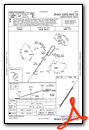
Nearby Airports with Instrument Procedures
| ID | Name | Heading / Distance | ||
|---|---|---|---|---|
 |
KDLC | Dillon County Airport | 354° | 16.1 |
|
KFLO | Florence Regional Airport | 270° | 19.4 |
|
KHYW | Conway-Horry County Airport | 153° | 23.6 |
|
5J9 | Twin City Airport | 103° | 24.0 |
|
KLBT | Lumberton Regional Airport | 027° | 29.1 |
|
51J | Lake City Municipal Cj Evans Field Airport | 227° | 29.2 |
|
KCPC | Columbus County Regional Airport | 079° | 31.3 |
|
KUDG | Darlington County Airport | 300° | 31.7 |
|
KBBP | Marlboro County Jetport/H E Avent Field Airport | 323° | 33.0 |
|
KMYR | Myrtle Beach International Airport | 145° | 36.2 |
|
KMEB | Laurinburg/Maxton Airport | 357° | 36.6 |
|
KCRE | Grand Strand Airport | 125° | 37.7 |
Airport Images
Do you have a recent image of this airport? Upload it here!


