Login
Register


CYSH
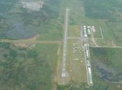
Smiths Falls-Montague (Russ Beach) Airport
VFR Chart of CYSH
Sectional Charts at SkyVector.com
IFR Chart of CYSH
Enroute Charts at SkyVector.com
Location Information for CYSH
Coordinates: N44°56.75' / W75°56.42'View all Airports in Ontario, Canada.
Elevation is 418 feet MSL.
Magnetic Variation is 14° West
Time Zone is UTC-5(4).
Operations Data
|
|
Customs Information
AOE/CAN
Airport Communications
| Aerodrome Traffic Frequency (ATF) | UNICOM limited hours other times traffic 122.7 5NM 3400 ASL excluding the airspace that lies within Ottawa TCA class C airspace. |
|---|
Nearby Navigation Aids
|
| ||||||||||||||||||||||||||||||||||||||||||||||||||||||||||||


Runway 06/24
| Dimensions: | 3998 x 75 feet. | |
|---|---|---|
| Surface: | asphalt | |
| Remarks | Rwy 24 up 0.7% first third | |
| Runway 06 | Runway 24 | |
| Runway Heading: | 064° | 244° |
| Glide Slope Indicator | APAPI - Abbreviated PAPI for aircraft with eye-to-wheel height up to 10 feet. | APAPI - Abbreviated PAPI for aircraft with eye-to-wheel height up to 10 feet. |
Runway Conditions Reporting Source
Operator Ltd win maint
Services Available
| Fuel Available | 100LL (self-serve H24) |
|---|---|
| Servicing Available | Minor Repairs, Tie Downs |
Public Facilities
| Location | Facilities | Remarks |
|---|---|---|
| In Terminal Building | Telephone | 7,8 |
| Within 5 NM | Food, Taxi, Medical Aid, Accomodations | |
| Within 30 NM | Car Rental |
Flight Planning
| Instructions | (bil) |
|---|---|
| Flight Information Centre (FIC) | Québec 866-WXBRIEF or 866-GOMÉTÉO (Toll free within Canada) or 866-541-4105 (Toll free within Canada & USA) |
| Weather (WX) | WxCam |
Aerodrome Operator
Smiths Falls Flying Club 613-430-5060
Reg
Nearby Airports with Instrument Procedures
| ID | Name | Heading / Distance | ||
|---|---|---|---|---|
 |
CYOW | Ottawa/Macdonald-Cartier International Airport | 041° | 25.4 |
|
KOGS | Ogdensburg International Airport | 141° | 25.8 |
|
CYND | Ottawa/Gatineau Airport | 038° | 38.1 |
|
KPTD | Potsdam Municipal/Damon Field Airport | 124° | 45.3 |
|
KMSS | Massena International-Richards Field Airport | 104° | 46.7 |
|
CMB7 | Maxville (Bourdon Farm) Airport | 082° | 51.6 |
|
CYGK | Kingston Airport | 227° | 51.5 |
|
KGTB | Wheeler-Sack AAF Airport | 183° | 54.2 |
|
KART | Watertown International Airport | 197° | 57.3 |
|
KMAL | Malone-Dufort Airport | 108° | 68.9 |
|
CYTA | Pembroke Airport | 329° | 78.2 |
|
KSLK | Adirondack Regional Airport | 127° | 81.5 |
Airport Images

By: H-Ottawa
By: H-Ottawa


