Login
Register


D81
Red Lake Falls Municipal Airport
Official FAA Data Effective 2025-12-25 0901Z
Chart Supplement

VFR Chart of D81
Sectional Charts at SkyVector.com
IFR Chart of D81
Enroute Charts at SkyVector.com
Location Information for D81
Coordinates: N47°49.59' / W96°15.59'Located 03 miles S of Red Lake Falls, Minnesota on 148 acres of land. View all Airports in Minnesota.
Estimated Elevation is 1060 feet MSL.
Operations Data
|
|
Airport Communications
| CTAF: | 122.900 |
|---|---|
| AWOS-3PT at TVF (14.4 N): | 119.025 218-681-1918 |
| AWOS-3 at CKN (14.5 W): | 126.425 218-281-3018 |
| AWOS-3 at FSE (24.1 SE): | 118.35 218-435-6448 |
Nearby Navigation Aids
|
| ||||||||||||||||||||||||||||||||||||||||||||||||


Runway 15/33
| Dimensions: | 2500 x 60 feet / 762 x 18 meters | |
|---|---|---|
| Surface: | Asphalt in Good Condition | |
| Edge Lighting: | Non-Standard NSTD LIRL; LGTS 40 FT OFF SIDES OF RY. | |
| Runway 15 | Runway 33 | |
| Coordinates: | N47°49.78' / W96°15.71' | N47°49.40' / W96°15.46' |
| Elevation: | 1060.0 | 1060.0 |
| Traffic Pattern: | Left | Left |
| Runway Heading: | 156° True | 336° True |
| Markings: | Basic in good condition. | Basic in good condition. |
Services Available
| Fuel: | NONE |
|---|---|
| Transient Storage: | Tiedowns |
| Airframe Repair: | NONE |
| Engine Repair: | NONE |
| Bottled Oxygen: | NONE |
| Bulk Oxygen: | NONE |
| Other Services: | CROP DUSTING SERVICES |
Ownership Information
| Ownership: | Publicly owned | |
|---|---|---|
| Owner: | CITY OF RED LAKE FALLS | |
| 108 - 2ND STREET SW, BOX 37 | ||
| RED LAKE FALLS, MN 56750 | ||
| 218-253-2684 | ||
| Manager: | MATT SWEDRA | |
| 108 - 2ND STREET SW, BOX 37 | ||
| RED LAKE FALLS, MN 56750 | ||
| (218) 230-5410 | ||
Other Remarks
- ULTRALIGHTS ON & INVOF ARPT.
- FOR CD CTC MINNEAPOLIS ARTCC AT 651-463-5588.
Nearby Airports with Instrument Procedures
| ID | Name | Heading / Distance | ||
|---|---|---|---|---|
 |
KCKN | Crookston Municipal/Kirkwood Field Airport | 273° | 14.7 |
|
KTVF | Thief River Falls Regional Airport | 011° | 14.7 |
|
D14 | Fertile Municipal Airport | 184° | 16.5 |
|
KFSE | Fosston Municipal/Anderson Field Airport | 125° | 24.2 |
|
D37 | Warren Municipal Airport | 320° | 28.5 |
|
D00 | Norman County Ada/Twin Valley Airport | 189° | 34.5 |
|
3N8 | Mahnomen County Airport | 158° | 36.6 |
|
KGFK | Grand Forks International Airport | 281° | 37.7 |
|
3H4 | Hillsboro Municipal Airport | 229° | 42.9 |
|
KRDR | Grand Forks AFB Airport | 280° | 46.8 |
|
4V4 | Northwood Municipal/Vince Field Airport | 264° | 54.2 |
|
KGAF | Hutson Field Airport | 308° | 56.6 |
Airport Images
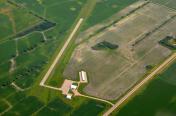
By: winglet714


