Login
Register


DDC
Dodge City Regional Airport
Official FAA Data Effective 2026-02-19 0901Z
Chart Supplement

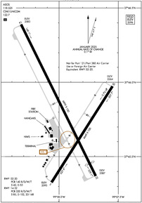
KDDC Airport Diagram
VFR Chart of KDDC
Sectional Charts at SkyVector.com
IFR Chart of KDDC
Enroute Charts at SkyVector.com
Location Information for KDDC
Coordinates: N37°45.79' / W99°57.93'Located 03 miles E of Dodge City, Kansas on 451 acres of land. View all Airports in Kansas.
Surveyed Elevation is 2595 feet MSL.
Operations Data
|
|
Airport Communications
| ASOS: | 118.525 Tel. 620-501-5064 |
|---|---|
| UNICOM: | 122.700 |
| CTAF: | 122.700 |
| AWOS-3PT at MEJ (34.5 SW): | 119.425 620-518-2544 |
| ASOS at GCK (37.3 W): | 121.325 620-275-0803 |
| AWOS-3PT at 48K (42.9 N): | 118.575 785-261-2002 |
- APCH/DEP CTL SVC PRVDD BY KANSAS CITY ARTCC (ZKC) ON FREQS 125.2/285.425 (GARDEN CITY RCAG).
Nearby Navigation Aids
|
| ||||||||||||||||||||||||||||||||||||||||||||||||


Runway 14/32
| Dimensions: | 6899 x 100 feet / 2103 x 30 meters | |
|---|---|---|
| Surface: | Asphalt in Fair Condition | |
| Weight Limits: | S-85, D-102, ST-168
PCR VALUE: 320/R/D/W/T
| |
| Edge Lighting: | Medium Intensity | |
| Runway 14 | Runway 32 | |
| Coordinates: | N37°46.39' / W99°58.32' | N37°45.37' / W99°57.69' |
| Elevation: | 2582.8 | 2586.5 |
| Traffic Pattern: | Left | Left |
| Runway Heading: | 154° True | 334° True |
| Displaced Threshold: | 569 Feet | |
| Declared Distances: | TORA:6899 TODA:6899 ASDA:6329 LDA:6329 | TORA:6899 TODA:6899 ASDA:6899 LDA:6329 |
| Markings: | Precision Instrument in good condition. | Precision Instrument in good condition. |
| Glide Slope Indicator | V4L (3.00° Glide Path Angle) | V4L (3.00° Glide Path Angle) |
| Approach Lights: | MALSR 1,400 Foot Medium-intensity Approach Lighting System with runway alignment indicator lights. | |
| REIL: | Yes | |
Runway 02/20
RWY 02/20 NOT AVBL FOR PART 121/PART 380 OPS WITH SKED PAX CARRYING OPS MORE THAN 9 PAX SEATS AND NON-SKED PAX CARRYING OPS MORE THAN 30 PAX SEATS. | ||
| Dimensions: | 4649 x 100 feet / 1417 x 30 meters | |
|---|---|---|
| Surface: | Asphalt in Fair Condition | |
| Weight Limits: | S-42, D-53
PCR VALUE: 140/R/D/W/T
| |
| Edge Lighting: | Medium Intensity | |
| Runway 02 | Runway 20 | |
| Coordinates: | N37°45.33' / W99°58.06' | N37°45.97' / W99°57.55' |
| Elevation: | 2595.0 | 2563.8 |
| Traffic Pattern: | Left | Left |
| Runway Heading: | 32° True | 212° True |
| Declared Distances: | TORA:4649 TODA:4649 ASDA:4649 LDA:4649 | TORA:4649 TODA:4649 ASDA:4649 LDA:4649 |
| Markings: | Non-Precision Instrument in fair condition. | Non-Precision Instrument in fair condition. |
| Glide Slope Indicator | P4L (3.00° Glide Path Angle) | P4L (3.00° Glide Path Angle) |
Services Available
| Fuel: | 100LL (blue), Jet-A |
|---|---|
| Transient Storage: | Hangars,Tiedowns |
| Airframe Repair: | MAJOR |
| Engine Repair: | MAJOR |
| Bottled Oxygen: | NONE |
| Bulk Oxygen: | LOW |
| Other Services: | CROP DUSTING SERVICES,AIR AMBULANCE SERVICES,CHARTER SERVICE,PILOT INSTRUCTION,AIRCRAFT RENTAL,AIRCRAFT SALES |
Ownership Information
| Ownership: | Publicly owned | |
|---|---|---|
| Owner: | CITY OF DODGE CITY | |
| PO BOX 880 | ||
| DODGE CITY, KS 67801 | ||
| 620-225-8100 | ||
| Manager: | MR ELIEL MARIN | |
| 100 AIRPORT RD | ||
| DODGE CITY, KS 67801 | ||
| 620-225-8280 | ||
Other Remarks
- RWY ENDS 02 & 20 NOT VSB FM OPPOSITE ENDS.
- FOR CD IF UNA TO CTC ON FSS FREQ, CTC KANSAS CITY ARTCC AT 913-254-8508.
- TWY B BTN E SIDE RWY 14/32 & APCH END RWY 20, TWY B SOUTH END OF S APRON & APCH APCH END OF RWY 02 & TWY B1 UNUSBL BY ACR.
- DUSK-DAWN. ACTVT MALSR RWY 14; REIL RWY 32; PAPI RWY 02 & 20, VASI RWY 14 & 32; MIRL RWY 14/32 & 02/20 - CTAF
Weather Minimums

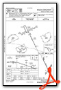
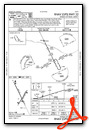
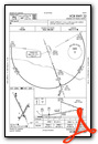
Instrument Approach Procedure (IAP) Charts


Nearby Airports with Instrument Procedures
| ID | Name | Heading / Distance | ||
|---|---|---|---|---|
 |
K79 | Jetmore Municipal Airport | 014° | 13.7 |
|
KMEJ | Meade Municipal Airport | 212° | 34.5 |
|
KGCK | Garden City Regional Airport | 285° | 37.4 |
|
48K | Ness City Municipal Airport | 003° | 42.7 |
|
3K8 | Comanche County Airport | 136° | 44.3 |
|
KLQR | Larned-Pawnee County Airport | 057° | 49.5 |
|
KBFK | Buffalo Municipal Airport | 162° | 56.4 |
|
KPTT | Pratt Regional Airport | 093° | 58.1 |
|
KTQK | Scott City Municipal Airport | 314° | 60.9 |
|
KGBD | Great Bend Municipal Airport | 056° | 62.9 |
|
KLBL | Liberal Mid-America Regional Airport | 228° | 64.2 |
|
KULS | Ulysses Airport | 262° | 67.7 |
Fuel Providers

Airport Images
Do you have a recent image of this airport? Upload it here!


