Login
Register


ULS
Ulysses Airport
Official FAA Data Effective 2026-01-22 0901Z
Chart Supplement

VFR Chart of KULS
Sectional Charts at SkyVector.com
IFR Chart of KULS
Enroute Charts at SkyVector.com
Location Information for KULS
Coordinates: N37°36.24' / W101°22.41'Located 01 miles N of Ulysses, Kansas on 405 acres of land. View all Airports in Kansas.
Surveyed Elevation is 3071 feet MSL.
Operations Data
|
|
Airport Communications
| AWOS-3PT: | 118.95 Tel. 620-424-3747 |
|---|---|
| CTAF: | 122.800 |
| UNICOM: | 122.800 |
| AWOS-3PT at JHN (17.0 W): | 124.175 620-492-2100 |
| AWOS-3PT at 36K (22.7 N): | 118.225 620-355-4004 |
| AWOS-3PT at HQG (26.4 S): | 118.600 620-544-4000 |
- APCH/DEP CTL SVC PRVDD BY KANSAS CITY ARTCC (ZKC) ON 125.2/285.425 (GARDEN CITY RCAG).
Nearby Navigation Aids
|
| ||||||||||||||||||||||||||||||||||||||||||||||||


Runway 17/35
| Dimensions: | 6000 x 100 feet / 1829 x 30 meters | |
|---|---|---|
| Surface: | Concrete in Good Condition | |
| Weight Limits: | 19 /R/C/X/U, S-45, D-60 | |
| Edge Lighting: | Medium Intensity | |
| Runway 17 | Runway 35 | |
| Coordinates: | N37°36.97' / W101°22.43' | N37°35.98' / W101°22.42' |
| Elevation: | 3065.3 | 3060.3 |
| Traffic Pattern: | Left | Left |
| Runway Heading: | 180° True | 360° True |
| Markings: | Non-Precision Instrument in good condition. | Non-Precision Instrument in good condition. |
| Glide Slope Indicator | P4L (3.00° Glide Path Angle) | P4L (3.00° Glide Path Angle) |
| REIL: | Yes | Yes |
| Obstacles: | 40 ft Power Line 1400 ft from runway | |
Runway 12/30
| Dimensions: | 4600 x 60 feet / 1402 x 18 meters | |
|---|---|---|
| Surface: | Concrete in Good Condition | |
| Weight Limits: | 7 /R/C/X/U, S-12 | |
| Edge Lighting: | Medium Intensity | |
| Runway 12 | Runway 30 | |
| Coordinates: | N37°36.17' / W101°22.76' | N37°35.69' / W101°22.03' |
| Elevation: | 3071.0 | 3061.9 |
| Traffic Pattern: | Left | Left |
| Runway Heading: | 130° True | 310° True |
| Markings: | Non-Precision Instrument in good condition. | Non-Precision Instrument in good condition. |
| Glide Slope Indicator | P2L (3.00° Glide Path Angle) | P2L (3.00° Glide Path Angle) |
| Obstacles: | 16 ft Road 700 ft from runway ALSO 50 FT BLDG, 1420 FT DSTC, 310 FT R, 24:1. |
50 ft Antenna 925 ft from runway, 315 ft right of center |
Services Available
| Fuel: | 100LL (blue), Jet-A |
|---|---|
| Transient Storage: | Hangars,Tiedowns |
| Airframe Repair: | MAJOR |
| Engine Repair: | MAJOR |
| Bottled Oxygen: | NONE |
| Bulk Oxygen: | NONE |
| Other Services: | CROP DUSTING SERVICES,PILOT INSTRUCTION,AIRCRAFT RENTAL |
Ownership Information
| Ownership: | Publicly owned | |
|---|---|---|
| Owner: | GRANT COUNTY | |
| 108 S GLENN | ||
| ULYSSES, KS 67880-2551 | ||
| 620-356-1335 | ||
| Manager: | STEVE RICE | |
| PO BOX 412 | ||
| ULYSSES, KS 67880 | ||
| 620-952-0954 | ||
Other Remarks
- PUBLIC PHONE AVBL 24 HRS 620-356-9306.
- GLIDER & ULTRA LIGHT ACTIVITY ON & INVOF ARPT.
- FOR CD IF UNA TO CTC ON FSS FREQ, CTC KANSAS CITY ARTCC AT 913-254-8508.
- ACTVT REIL RWY 17 & 35; PAPI RWY 12, 17, 30, & 35; MIRL RWYS 12/30 & 17/35 - CTAF.
Weather Minimums

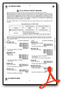
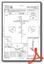
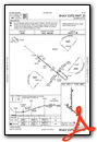
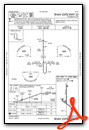
Instrument Approach Procedure (IAP) Charts

Nearby Airports with Instrument Procedures
| ID | Name | Heading / Distance | ||
|---|---|---|---|---|
 |
KJHN | Stanton County Municipal Airport | 266° | 17.1 |
|
KHQG | Hugoton Municipal Airport | 179° | 26.4 |
|
3K3 | Syracuse-Hamilton County Municipal Airport | 323° | 29.6 |
|
KGCK | Garden City Regional Airport | 057° | 36.5 |
|
KLBL | Liberal Mid-America Regional Airport | 149° | 39.0 |
|
KEHA | Elkhart-Morton County Airport | 214° | 43.5 |
|
3K7 | Mark Hoard Memorial Airport | 001° | 51.2 |
|
KMEJ | Meade Municipal Airport | 111° | 52.4 |
|
5K2 | Tribune Municipal Airport | 340° | 53.8 |
|
KGUY | Guymon Municipal Airport | 186° | 55.5 |
|
KTQK | Scott City Municipal Airport | 023° | 57.1 |
|
8V7 | Springfield Municipal Airport | 262° | 60.0 |
Airport Images
Do you have a recent image of this airport? Upload it here!


