Login
Register


DLS
Columbia Gorge Regional/The Dalles Municipal Airport
Official FAA Data Effective 2025-11-27 0901Z
Chart Supplement

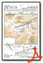
VFR Chart of KDLS
Sectional Charts at SkyVector.com
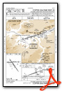
IFR Chart of KDLS
Enroute Charts at SkyVector.com
Location Information for KDLS
Coordinates: N45°37.16' / W121°10.10'Located 02 miles NE of The Dalles, Oregon on 997 acres of land. View all Airports in Oregon.
Surveyed Elevation is 246 feet MSL.
Operations Data
|
|
Airport Communications
| ASOS: | 135.175 Tel. 509-767-1726 |
|---|---|
| CTAF: | 123.000 |
| UNICOM: | 123.000 |
| AWOS-3 at 4S2 (15.7 W): | 134.375 541-386-2386 |
| ATIS at TTD (52.0 W): | 135.625 |
| ASOS at TTD (52.0 W): | 135.625 503-492-2887 |
- APCH/DEP CTL SVC PRVDD SEATTLE ARTCC (ZSE) ON FREQS 119.65/257.6 (KLICKITAT RCAG).
Nearby Navigation Aids
|
| ||||||||||||||||||||||||||||||||||||||||||||||||


Runway 13/31
| Dimensions: | 5097 x 100 feet / 1554 x 30 meters | |
|---|---|---|
| Surface: | Asphalt in Good Condition | |
| Weight Limits: | 32 /F/C/X/T, S-30, D-30 | |
| Edge Lighting: | Medium Intensity | |
| Runway 13 | Runway 31 | |
| Coordinates: | N45°37.41' / W121°10.41' | N45°36.73' / W121°9.71' |
| Elevation: | 210.9 | 238.9 |
| Traffic Pattern: | Left | Left |
| Runway Heading: | 145° True | 325° True |
| Displaced Threshold: | 200 Feet | |
| Markings: | Basic in good condition. | Basic in good condition. |
| REIL: | Yes | |
| Obstacles: | 15 ft Trees 201 ft from runway, 107 ft left of center CNTLG OBSTN EXCEEDS 45 DEG SLP. |
|
Runway 07/25
| Dimensions: | 4647 x 100 feet / 1416 x 30 meters | |
|---|---|---|
| Surface: | Asphalt in Good Condition | |
| Weight Limits: | S-30, D-30 | |
| Edge Lighting: | Medium Intensity | |
| Runway 07 | Runway 25 | |
| Coordinates: | N45°37.25' / W121°10.68' | N45°37.27' / W121°9.59' |
| Elevation: | 211.1 | 242.7 |
| Traffic Pattern: | Left | Left |
| Runway Heading: | 88° True | 268° True |
| Displaced Threshold: | 440 Feet | 196 Feet |
| Markings: | Precision Instrument in good condition. | Precision Instrument in good condition. |
| Obstacles: | 34 ft Pole 796 ft from runway, 112 ft left of center RWY 07 , SLP 39:1 TO DTHR. RWY 07 +15 FTROAD, 0 FT FM END, 200 FT R. |
THLD DSPLCD TO PROVIDE SAFETY AREA. |
Services Available
| Fuel: | 100LL (blue), Jet A-1 |
|---|---|
| Transient Storage: | Tiedowns |
| Airframe Repair: | MAJOR |
| Engine Repair: | MAJOR |
| Bottled Oxygen: | NONE |
| Bulk Oxygen: | NONE |
| Other Services: | CROP DUSTING SERVICES,PILOT INSTRUCTION,AIRCRAFT RENTAL |
Ownership Information
| Ownership: | Publicly owned | |
|---|---|---|
| Owner: | CITY OF THE DALLES/KLICKITAT COUNTY | |
| PO BOX 285 | ||
| DALLES PORT, WA 98617 | ||
| 509-767-2272 | ||
| Manager: | JEFF RENARD | |
| PO BOX 285 | ||
| DALLES PORT, WA 98617 | ||
| 509-767-2272 | ADNL CTC - 541-288-6766. MANAGER@FLYCGRA.COM. | |
Other Remarks
- MTNS BYD 5000' APCH RY 31.
- ALL TWYS MARKED WITH REFLECTORS.
- WATERFOWL ON AND INVOF ARPT.
- PRIOR PERMISSION REQUIRED FOR OVERWEIGHT LNDGS.
- FOR CD CTC SEATTLE ARTCC AT 253-351-3694.
- ACTVT MIRL RYS 13/31 & 07/25, & REIL RY 31 - CTAF. REIL OPERATES ON 7 CLICKS ONLY.
Weather Minimums

Instrument Approach Procedure (IAP) Charts

Departure Procedure Obstacles (DPO) Charts

Nearby Airports with Instrument Procedures
| ID | Name | Heading / Distance | ||
|---|---|---|---|---|
 |
KTTD | Portland-Troutdale Airport | 265° | 52.1 |
|
S33 | Madras Municipal Airport | 179° | 57.0 |
|
KPDX | Portland International Airport | 268° | 60.2 |
|
KVUO | Pearson Field Airport | 270° | 62.7 |
|
KYKM | Yakima Air Trml/Mcallister Field Airport | 024° | 62.6 |
|
9S9 | Lexington Airport | 098° | 63.1 |
|
KUAO | Aurora State Airport | 252° | 71.3 |
|
KSPB | Scappoose Airport | 277° | 71.8 |
|
KHIO | Portland-Hillsboro Airport | 267° | 75.3 |
|
KKLS | Southwest Washington Regional Airport | 293° | 78.5 |
|
S39 | Prineville Airport | 171° | 80.7 |
|
KHRI | Hermiston Municipal Airport | 080° | 81.2 |
Fuel Providers


We proudly offer fuel from:

US Dollar per US Gallon
Price Guaranteed by FBO
Airport Images
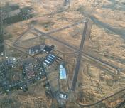
By: NW Aeronaut

By: Darren Lacock


