Login
Register


S33
Madras Municipal Airport
Official FAA Data Effective 2026-01-22 0901Z
Chart Supplement

VFR Chart of S33
Sectional Charts at SkyVector.com
IFR Chart of S33
Enroute Charts at SkyVector.com
Location Information for S33
Coordinates: N44°40.21' / W121°9.31'Located 03 miles NW of Madras, Oregon on 2098 acres of land. View all Airports in Oregon.
Surveyed Elevation is 2437 feet MSL.
Operations Data
|
|
Airport Communications
| AWOS-3PT: | 132.425 Tel. 541-475-0494 |
|---|---|
| UNICOM: | 122.800 |
| CTAF: | 122.800 |
| ASOS at RDM (24.9 S): | 119.025 541-504-8743 |
| ATIS at RDM (25.0 S): | 119.025 |
| AWOS-3PT at S39 (25.5 SE): | 118.325 541-447-4060 |
- APCH/DEP CTL SVC PRVDD BY SEATTLE ARTCC (ZSE) ON FREQ 126.15/269.475 (REDMOND RCAG).
Nearby Navigation Aids
|
| ||||||||||||||||||||||||||||||||||||||||||||||||


Runway 16/34
| Dimensions: | 5091 x 75 feet / 1552 x 23 meters | |
|---|---|---|
| Surface: | Asphalt in Good Condition | |
| Weight Limits: | S-75, D-120, ST-180 | |
| Edge Lighting: | Medium Intensity | |
| Runway 16 | Runway 34 | |
| Coordinates: | N44°40.44' / W121°9.20' | N44°39.60' / W121°9.20' |
| Elevation: | 2430.3 | 2437.4 |
| Traffic Pattern: | Left | Left |
| Runway Heading: | 180° True | 0 |
| Markings: | Non-Precision Instrument in good condition. | Non-Precision Instrument in good condition. |
| Glide Slope Indicator | V4L (3.00° Glide Path Angle) | |
| REIL: | Yes | |
Runway 04/22
| Dimensions: | 2701 x 50 feet / 823 x 15 meters | |
|---|---|---|
| Surface: | Asphalt in Fair Condition | |
| Weight Limits: | S-16 | |
| Runway 04 | Runway 22 | |
| Coordinates: | N44°40.43' / W121°9.76' | N44°40.69' / W121°9.25' |
| Elevation: | 2417.0 | 2424.7 |
| Traffic Pattern: | Left | Left |
| Runway Heading: | 55° True | 235° True |
| Markings: | Basic in fair condition. | Basic in fair condition. |
| Obstacles: | 15 ft Road 200 ft from runway, 240 ft right of center +5 FT FENCE 190 FT FM RY END 228 FT R. |
|
Helipad H1
| Dimensions: | 100 x 100 feet / 30 x 30 meters | |
|---|---|---|
| Surface: | Asphalt | |
| Coordinates: | N44°40.59' / W121°10.05' | N0°0.00' / E0°0.00' |
| Elevation: | 2414.0 | |
| Markings: | Basic in good condition. | |
Services Available
| Fuel: | 100LL (blue), Jet-A |
|---|---|
| Transient Storage: | Hangars,Tiedowns |
| Airframe Repair: | MAJOR |
| Engine Repair: | MAJOR |
| Bottled Oxygen: | HIGH/LOW |
| Bulk Oxygen: | NONE |
| Other Services: | CROP DUSTING SERVICES,CHARTER SERVICE,PILOT INSTRUCTION,PARACHUTE JUMP ACTIVITY,AIRCRAFT RENTAL |
Ownership Information
| Ownership: | Publicly owned | |
|---|---|---|
| Owner: | CITY | |
| 125 SW E ST., CITY HALL, CITY HALL | ||
| MADRAS, OR 97741 | ||
| 541-475-2344 | ||
| Manager: | LORRAINE MARTINELLI | |
| 2028 NW BERG DR | ||
| MADRAS, OR 97741 | ||
| 541-777-4935 | ||
Other Remarks
- DEER, COYOTE AND COUGAR ON & INVOF ARPT.
- FOR CD CTC SEATTLE ARTCC AT 253-351-3694.
- COLD TEMPERATURE AIRPORT. ALTITUDE CORRECTION REQUIRED AT OR BELOW -20C.
- TLOF DIMENSIONS 100 X 100. FATO DIMENSIONS 162 X 162. SAFETY AREA DIMENSIONS 24 X 24. PRIMARY INGRESS/EGRESS; 164/344 DEGS.
- RY 04/22 MKD WITH WHITE REFLECTORS.
- ACTVT REIL RWY 34; VASI RWY 34; MRIL RWY 16/34 - CTAF
Weather Minimums

Instrument Approach Procedure (IAP) Charts
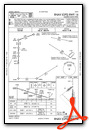

Nearby Airports with Instrument Procedures
| ID | Name | Heading / Distance | ||
|---|---|---|---|---|
 |
KRDM | Roberts Field Airport | 179° | 25.0 |
|
S39 | Prineville Airport | 154° | 25.3 |
|
KBDN | Bend Municipal Airport | 183° | 34.6 |
|
S21 | Sunriver Airport | 195° | 49.3 |
|
KDLS | Columbia Gorge Regional/The Dalles Municipal Airport | 359° | 57.0 |
|
KTTD | Portland-Troutdale Airport | 315° | 74.7 |
|
KUAO | Aurora State Airport | 297° | 77.0 |
|
9S9 | Lexington Airport | 052° | 78.1 |
|
KSLE | Mcnary Field Airport | 280° | 80.2 |
|
S12 | Albany Municipal Airport | 269° | 81.6 |
|
KPDX | Portland International Airport | 312° | 82.4 |
|
KVUO | Pearson Field Airport | 312° | 85.5 |
Airport Images
Do you have a recent image of this airport? Upload it here!


