Login
Register


DMO
Sedalia Regional Airport
Official FAA Data Effective 2026-02-19 0901Z
Chart Supplement

VFR Chart of KDMO
Sectional Charts at SkyVector.com
IFR Chart of KDMO
Enroute Charts at SkyVector.com
Location Information for KDMO
Coordinates: N38°42.45' / W93°10.56'Located 02 miles E of Sedalia, Missouri on 544 acres of land. View all Airports in Missouri.
Surveyed Elevation is 909 feet MSL.
Operations Data
|
|
Airport Communications
| ASOS: | 120.525 Tel. 660-826-8225 |
|---|---|
| WHITEMAN APPROACH: | 127.45 284.0 |
| WHITEMAN DEPARTURE: | 125.925 343.65 |
| CTAF: | 122.800 |
| UNICOM: | 122.800 |
| ATIS at SZL (17.5 W): | 239.025 |
| AWOS-3PT at RAW (23.0 S): | 118.325 660-547-3761 |
| AWOS-3PT at MHL (23.2 N): | 118.675 660-886-9130 |
- APCH/DEP SVC PRVDD BY KANSAS CITY ARTCC ON FREQS 135.575/323.15 (KNOB NOSTER RCAG) WHEN WHITEMAN APCH CTL CLSD.
Nearby Navigation Aids
|
| ||||||||||||||||||||||||||||||||||||||||||||||||||||||


Runway 18/36
| Dimensions: | 5500 x 100 feet / 1676 x 30 meters | |
|---|---|---|
| Surface: | Concrete in Excellent Condition | |
| Weight Limits: | 17 /R/C/W/T, S-50, D-65 | |
| Edge Lighting: | Medium Intensity | |
| Runway 18 | Runway 36 | |
| Coordinates: | N38°43.01' / W93°10.34' | N38°42.10' / W93°10.38' |
| Elevation: | 882.1 | 900.4 |
| Traffic Pattern: | Right | |
| Runway Heading: | 182° True | 2° True |
| Markings: | Non-Precision Instrument in good condition. | Non-Precision Instrument in good condition. |
| Glide Slope Indicator | P4L (3.00° Glide Path Angle) | P4L (3.00° Glide Path Angle) |
| REIL: | Yes | Yes |
Runway 05/23
| Dimensions: | 3519 x 50 feet / 1073 x 15 meters | |
|---|---|---|
| Surface: | Asphalt in Fair Condition | |
| Weight Limits: | 7 /F/D/X/T, S-19 | |
| Edge Lighting: | Medium Intensity | |
| Runway 05 | Runway 23 | |
| Coordinates: | N38°42.10' / W93°11.16' | N38°42.44' / W93°10.56' |
| Elevation: | 909.5 | 884.3 |
| Traffic Pattern: | Right | |
| Runway Heading: | 54° True | 234° True |
| Markings: | Basic in good condition. | Basic in good condition. |
| Obstacles: | 54 ft Tree 615 ft from runway, 270 ft left of center | 15 ft Brush 243 ft from runway, 125 ft left of center BRUSH 5-6 FT TALL 130-200 FT FM THR 130 FT RIGHT. |
Services Available
| Fuel: | 100LL (blue), Jet-A |
|---|---|
| Transient Storage: | Tiedowns |
| Airframe Repair: | MAJOR |
| Engine Repair: | MAJOR |
| Bottled Oxygen: | NONE |
| Bulk Oxygen: | HIGH/LOW |
| Other Services: | CROP DUSTING SERVICES,PILOT INSTRUCTION,AIRCRAFT RENTAL |
Ownership Information
| Ownership: | Publicly owned | |
|---|---|---|
| Owner: | CITY OF SEDALIA | |
| 200 S. OSAGE | ||
| SEDALIA, MO 65301 | ||
| 660-827-3000 | ||
| Manager: | MITCHELL MULLEN | |
| 1900 E BOONEVILLE | ||
| SEDALIA, MO 65301 | ||
| 660-826-4128 | ||
Other Remarks
- WILDLIFE ON RYS EARLY MORNING & DUSK.
- 100LL SELF SERVICE AVBL 24/7
- JET A AVBL AFTER HOURS - $80 FEE - CALL 660-826-8100
- FOR CD IF UNA TO CTC ON FSS FREQ, CTC WHITEMAN APCH AT 660-687-3132. WHEN WHITEMAN APCH IS CLSD, CTC KANSAS CITY ARTCC AT 913-254-8508.
- ACTVT REIL RWY 18 & 36; MIRL RWY 18/36 & 05/23 - CTAF. PAPI RWY 18 & 36 ON 24 HRS.
Weather Minimums


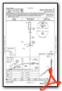
Instrument Approach Procedure (IAP) Charts

Nearby Airports with Instrument Procedures
| ID | Name | Heading / Distance | ||
|---|---|---|---|---|
 |
KSZL | Whiteman AFB Airport | 274° | 17.5 |
|
KRAW | Warsaw Municipal Airport | 200° | 23.0 |
|
KMHL | Marshall Memorial Municipal Airport | 356° | 23.3 |
|
KVER | Jesse Viertel Memorial Airport | 058° | 27.2 |
|
KRCM | Skyhaven Airport | 279° | 29.8 |
|
KGLY | Clinton Regional Airport | 228° | 31.8 |
|
KHIG | Higginsville Industrial Municipal Airport | 313° | 32.1 |
|
H79 | Eldon Model Airpark Airport | 125° | 35.2 |
|
K15 | Grand Glaize-Osage Beach Airport | 146° | 42.7 |
|
KCOU | Columbia Regional Airport | 081° | 45.4 |
|
KAIZ | Lee C Fine Memorial Airport | 140° | 47.1 |
|
KJEF | Jefferson City Memorial Airport | 097° | 48.4 |
Airport Images
Do you have a recent image of this airport? Upload it here!


