Login
Register


H79
Eldon Model Airpark Airport
Official FAA Data Effective 2026-01-22 0901Z
Chart Supplement

VFR Chart of H79
Sectional Charts at SkyVector.com
IFR Chart of H79
Enroute Charts at SkyVector.com
Location Information for H79
Coordinates: N38°21.70' / W92°34.28'Located 01 miles NE of Eldon, Missouri on 138 acres of land. View all Airports in Missouri.
Estimated Elevation is 917 feet MSL.
Operations Data
|
|
Airport Communications
| MIZZU APPROACH: | 124.1 353.925 |
|---|---|
| MIZZU DEPARTURE: | 124.1 353.925 |
| UNICOM: | 122.800 |
| CTAF: | 122.800 |
| AWOS-3PT at AIZ (16.0 S): | 135.325 573-348-0847 |
| AWOS-3PT at OZS (23.9 S): | 120.225 573-233-1004 |
| ASOS at JEF (24.0 NE): | 133.625 573-635-9266 |
Nearby Navigation Aids
|
| ||||||||||||||||||||||||||||||||||||||||||||||||


Runway 18/36
| Dimensions: | 4000 x 75 feet / 1219 x 23 meters | |
|---|---|---|
| Surface: | Concrete in Good Condition | |
| Weight Limits: | S-30 | |
| Edge Lighting: | Medium Intensity | |
| Runway 18 | Runway 36 | |
| Coordinates: | N38°22.02' / W92°34.26' | N38°21.37' / W92°34.29' |
| Elevation: | 917.0 | 903.1 |
| Traffic Pattern: | Right | |
| Runway Heading: | 182° True | 2° True |
| Markings: | Non-Precision Instrument in fair condition. | Non-Precision Instrument in fair condition. |
| Glide Slope Indicator | P4R (3.00° Glide Path Angle) | P4L (4.00° Glide Path Angle) |
| REIL: | Yes | Yes |
Services Available
| Fuel: | 100LL (blue), Jet A+ |
|---|---|
| Transient Storage: | Hangars,Tiedowns |
| Airframe Repair: | NOT AVAILABLE |
| Engine Repair: | NOT AVAILABLE |
| Bottled Oxygen: | NONE |
| Bulk Oxygen: | NONE |
Ownership Information
| Ownership: | Publicly owned | |
|---|---|---|
| Owner: | CITY OF ELDON | |
| 101 SOUTH OAK ST BOX 355 | ||
| ELDON, MO 65026 | ||
| 573-392-2291 | ||
| Manager: | MANDY ASBURY | |
| 101 SOUTH OAK ST BOX 355 | ||
| ELDON, MO 65026 | ||
| 573-392-2291 | ||
Other Remarks
- GEESE & OTHER WILDLIFE ON & INVOF ARPT.
- FOR CD CTC MIZZOU APCH AT 417-868-5620/5619.
- 0LL AUTO CREDIT CARD FUELING SYS 24 HRS A DAY 100LL, JET A.
- ACTVT MIRL RWY 18/36; REIL RWYS 18/36; PAPI RWYS 18/36 - CTAF.
- UNICOM UNMON.
Weather Minimums

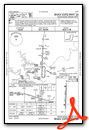
Instrument Approach Procedure (IAP) Charts

Nearby Airports with Instrument Procedures
| ID | Name | Heading / Distance | ||
|---|---|---|---|---|
 |
K15 | Grand Glaize-Osage Beach Airport | 198° | 15.9 |
|
KAIZ | Lee C Fine Memorial Airport | 176° | 15.9 |
|
KJEF | Jefferson City Memorial Airport | 054° | 23.9 |
|
KOZS | Camdenton Memorial-Lake Regional Airport | 193° | 24.0 |
|
KCOU | Columbia Regional Airport | 031° | 32.0 |
|
KDMO | Sedalia Regional Airport | 306° | 35.2 |
|
KVER | Jesse Viertel Memorial Airport | 351° | 35.5 |
|
KRAW | Warsaw Municipal Airport | 268° | 36.5 |
|
KFTT | Elton Hensley Memorial Airport | 042° | 39.1 |
|
KVIH | Rolla Ntl Airport | 110° | 40.4 |
|
KTBN | Waynesville-St Robert Regional Forney Field Airport | 151° | 42.4 |
|
KLBO | Floyd W Jones Lebanon Airport | 185° | 42.9 |
Airport Images
Do you have a recent image of this airport? Upload it here!


