Login
Register


DTS
Destin Exec Airport
Official FAA Data Effective 2026-02-19 0901Z
Chart Supplement

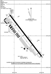
KDTS Airport Diagram
VFR Chart of KDTS
Sectional Charts at SkyVector.com
IFR Chart of KDTS
Enroute Charts at SkyVector.com
Location Information for KDTS
Coordinates: N30°24.00' / W86°28.29'Located 01 miles E of Destin, Florida on 395 acres of land. View all Airports in Florida.
Surveyed Elevation is 22 feet MSL.
Operations Data
|
|
Airport Communications
| ATIS: | 133.925 |
|---|---|
| ASOS: | 133.925 Tel. 850-654-7128 |
| DESTIN TOWER: | 118.45 |
| DESTIN GROUND: | 121.6 |
| EGLIN APPROACH: | 132.1 360.6 |
| EGLIN DEPARTURE: | 132.1 360.6 |
| CLEARANCE DELIVERY: | 121.6 127.7 ;WHEN TWR CLSD 377.2 |
| CTAF: | 118.450 |
| ATIS at VPS (5.7 NW): | 134.625 |
| ATIS at HRT (11.4 W): | 134.475 |
| ATIS at EGI (15.1 N): | 244.575 |
- CLASS D SVCS PRVDD BY EGLIN APCH WHEN DESTIN ATCT CLSD.
Nearby Navigation Aids
|
| ||||||||||||||||||||||||||||||||||||||||||||||||||||||||||||


Runway 14/32
| Dimensions: | 5001 x 100 feet / 1524 x 30 meters | |
|---|---|---|
| Surface: | Asphalt in Good Condition | |
| Weight Limits: | 25 /F/B/W/T, S-38, D-67, ST-113 | |
| Edge Lighting: | High Intensity | |
| Runway 14 | Runway 32 | |
| Coordinates: | N30°24.33' / W86°28.58' | N30°23.68' / W86°28.00' |
| Elevation: | 22.2 | 21.0 |
| Traffic Pattern: | Left | Left |
| Runway Heading: | 142° True | 322° True |
| Markings: | Non-Precision Instrument in good condition. | Non-Precision Instrument in good condition. |
| Glide Slope Indicator | P4L (3.00° Glide Path Angle) RWY 14 PAPI UNA BYD 6 DEG L OF RCL. | P4L (3.00° Glide Path Angle) RWY 32 PAPI UNUSABLE BEYOND 7 DEGREES LEFT AND RIGHT OF CNTRLN. |
| Obstacles: | 37 ft Trees 1485 ft from runway, 100 ft left of center | 117 ft Building 4880 ft from runway, 325 ft right of center |
Services Available
| Fuel: | 100LL (blue), Jet-A |
|---|---|
| Transient Storage: | Tiedowns |
| Airframe Repair: | MAJOR |
| Engine Repair: | MAJOR |
| Bottled Oxygen: | HIGH |
| Bulk Oxygen: | HIGH/LOW |
| Other Services: | AVIONICS,PILOT INSTRUCTION,AIRCRAFT RENTAL |
Ownership Information
| Ownership: | Publicly owned | |
|---|---|---|
| Owner: | OKALOOSA CO | |
| BOARD OF COMMISSIONERS, 302 N. WILSON ST. - SUITE 302 | ||
| CRESTVIEW, FL 32536 | ||
| 850-689-5000 | ||
| Manager: | TRACY STAGE | |
| 1701 STATE ROAD 85 NORTH | ||
| EGLIN AFB, FL 32542-1413 | ||
| 850-651-7160 | EXT 4 | |
Other Remarks
- EXERCISE VIGILANCE DUE TO CLOSE PROXIMITY TO EGLIN AFB LCTD 6 NM NW.
- ALL ACFT CTC EGLIN CD ON 127.7 FOR ATC DEP INSTR PRIOR TO TKOF WHEN TWR CLSD.
- WHEN TWR CLSD; IFR ACFT RMN ON GND & CTC DEP CTL FOR CLIMB OUT INSTR & IFR RLS.
- ARPT COND UNMON.
- PARASAILING & BANNER TOWING WI 5 NM.
- CAUTION: MEN & EQUIP ON & INVOF SAFETY AREA.
- FOR FBO SERVICES CONTACT 130.05.
- ACTVT PAPI RWY 14 & 32; HIRL RWY 14/32 - CTAF.
Weather Minimums

Instrument Approach Procedure (IAP) Charts
Nearby Airports with Instrument Procedures
| ID | Name | Heading / Distance | ||
|---|---|---|---|---|
 |
KVPS | Eglin AFB/Destin-Ft Walton Beach Airport | 330° | 5.7 |
|
KHRT | Hurlburt Field Airport | 278° | 11.4 |
|
KEGI | Duke Field,(Eglin Af Aux Nr 3) Airport | 350° | 15.1 |
|
KCEW | Bob Sikes Airport | 353° | 22.8 |
|
54J | Defuniak Springs Airport | 039° | 25.8 |
|
2R4 | Peter Prince Field Airport | 297° | 30.6 |
|
KNDZ | Whiting Field NAS South Airport | 302° | 33.3 |
|
KNSE | Whiting Field NAS North Airport | 304° | 34.5 |
|
KECP | Northwest Florida Beaches International Airport | 093° | 35.2 |
|
KPNS | Pensacola International Airport | 276° | 37.4 |
|
0J4 | Florala Municipal Airport | 012° | 39.3 |
|
KNPA | Pensacola NAS (Forrest Sherman Field) Airport | 266° | 44.0 |
Airport Images
Do you have a recent image of this airport? Upload it here!


Comments
Good service
The line crew and desk service at Destin are very good. No cards and it was only a mile to the hotel I was going to walk and they insisted on giving me a ride. Just really friendly and helpful like you would want. I will stop here again.