Login
Register
ECP
Northwest Florida Beaches International Airport
Official FAA Data Effective 2026-01-22 0901Z
VFR Chart of KECP
Sectional Charts at SkyVector.com
IFR Chart of KECP
Enroute Charts at SkyVector.com
Location Information for KECP
Coordinates: N30°21.49' / W85°47.74'Located 16 miles NW of Panama City, Florida on 4000 acres of land. View all Airports in Florida.
Surveyed Elevation is 68 feet MSL.
Operations Data
|
|
Airport Communications
| ATIS: | 119.975 |
|---|---|
| ASOS: | 119.975 Tel. 850-235-7857 |
| PANAMA CITY TOWER: | 118.95 |
| PANAMA CITY GROUND: | 121.65 |
| TYNDALL APPROACH: | 125.2 ;ABV 5000 FT |
| TYNDALL DEPARTURE: | 125.2 ;ABV 5000 FT |
| CLEARANCE DELIVERY: | 123.75 |
| CTAF: | 118.950 |
| EMERG: | 121.5 |
| ATIS at PAM (20.8 SE): | 254.4 |
| AWOS-3P at 54J (29.1 NW): | 118.725 850-892-0147 |
| ASOS at BCR (30.7 N): | 119.825 850-547-1431 |
- APCH/DEP SVC PRVDD BY JACKSONVILLE ARTCC ON FREQS 120.825/379.3 (PANAMA CITY RCAG) WHEN TYNDALL APCH CTL IS CLSD.
Nearby Navigation Aids
|
| ||||||||||||||||||||||||||||||||||||||||||||||||||||||||||||
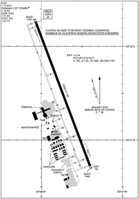
Runway 16/34
| Dimensions: | 10000 x 150 feet / 3048 x 46 meters | |
|---|---|---|
| Surface: | Concrete / Grooved in Excellent Condition | |
| Weight Limits: | S-100, D-155, ST-400, DT-750
PCR VALUE: 690/R/B/W/T
| |
| Edge Lighting: | High Intensity | |
| Runway 16 | Runway 34 | |
| Coordinates: | N30°22.27' / W85°48.07' | N30°20.72' / W85°47.40' |
| Elevation: | 68.8 | 53.9 |
| Runway Heading: | 159° True | 339° True |
| Markings: | Precision Instrument in good condition. | Precision Instrument in good condition. |
| Glide Slope Indicator | P4L (3.00° Glide Path Angle) | P4L (3.00° Glide Path Angle) |
| RVR Equipment | Touchdown Rollout | Touchdown Rollout |
| Approach Lights: | MALSR 1,400 Foot Medium-intensity Approach Lighting System with runway alignment indicator lights. | |
| REIL: | Yes | |
| Centerline Lights: | Yes | Yes |
| Obstacles: | 39 ft Trees 2180 ft from runway, 310 ft right of center | 61 ft Trees 2660 ft from runway, 595 ft left of center |
Services Available
| Fuel: | 100LL (blue), Jet-A |
|---|---|
| Transient Storage: | Hangars,Tiedowns |
| Airframe Repair: | NOT AVAILABLE |
| Engine Repair: | NOT AVAILABLE |
| Bottled Oxygen: | NONE |
| Bulk Oxygen: | NONE |
| Other Services: | PILOT INSTRUCTION,AIRCRAFT RENTAL |
Ownership Information
| Ownership: | Publicly owned | |
|---|---|---|
| Owner: | PANAMA CITY-BAY CO ARPT & INDST DIS | |
| 6300 WEST BAY PARKWAY | ||
| PANAMA CITY BEACH, FL 32409 | ||
| 850-763-6751 | ||
| Manager: | PARKER MCCLELLAN | |
| 6300 WEST BAY PARKWAY | ||
| PANAMA CITY BEACH, FL 32409 | ||
| 850-763-6751 | ||
Other Remarks
- MIL VIP ARR/DEP SHALL BE AT ARPT TERM WITH PRIOR APVL FM ARPT AUTH - 850-763-6751 EXT 306.
- TWY J BTN TWY D & TAXILANE F CLSD TO ACFT WITH WINGSPAN GTR THAN 80 FT EXC 1 HR PPR - 850-769-6033. TWY K, M, E2, E3 BTN TWY D & TAXILANE F RSTRD TO ACFT WITH WINGSPAN GTR THAN 80 FT.
- BIRDS ON & INVOF ARPT.
- WHEN ATCT CLSD ACTVT MALSR RWY 16; REIL RWY 34; TDZ RWY 16; CNTLN RWY 16/34; PAPI RWY 16 & 34; HIRL RWY 16/34 - CTAF.
Weather Minimums
Instrument Approach Procedure (IAP) Charts
Nearby Airports with Instrument Procedures
| ID | Name | Heading / Distance | ||
|---|---|---|---|---|
 |
KPAM | Tyndall AFB Airport | 146° | 20.8 |
 |
54J | Defuniak Springs Airport | 320° | 29.0 |
 |
KBCR | Tri-County Airport | 018° | 30.8 |
 |
KDTS | Destin Exec Airport | 274° | 35.2 |
 |
KVPS | Eglin AFB/Destin-Ft Walton Beach Airport | 281° | 38.6 |
 |
KEGI | Duke Field,(Eglin Af Aux Nr 3) Airport | 294° | 41.5 |
 |
33J | Geneva Municipal Airport | 354° | 41.7 |
 |
KMAI | Marianna Municipal Airport | 047° | 42.8 |
 |
KCEW | Bob Sikes Airport | 303° | 45.3 |
 |
KHRT | Hurlburt Field Airport | 275° | 46.5 |
 |
0J4 | Florala Municipal Airport | 327° | 48.9 |
 |
KAAF | Apalachicola Regional-Cleve Randolph Field Airport | 133° | 55.0 |


