Login
Register


E60
Eloy Municipal Airport
Official FAA Data Effective 2026-02-19 0901Z
Chart Supplement

VFR Chart of E60
Sectional Charts at SkyVector.com
IFR Chart of E60
Enroute Charts at SkyVector.com
Location Information for E60
Coordinates: N32°48.40' / W111°35.20'Located 03 miles NW of Eloy, Arizona on 371 acres of land. View all Airports in Arizona.
Surveyed Elevation is 1511 feet MSL.
Operations Data
|
|
Airport Communications
| UNICOM: | 122.800 |
|---|---|
| CTAF: | 122.800 |
| AWOS-3PT at P08 (11.2 NE): | 119.350 520-723-4920 |
| AWOS-3PT at CGZ (12.8 NW): | 132.175 520-836-3392 |
| AWOS-3 at A39 (20.1 NW): | 126.900 520-568-7704 |
Nearby Navigation Aids
|
| ||||||||||||||||||||||||||||||||||||||||||||||||


Runway 02/20
WIND 10 KT OR LESS; ARR RWY 20 & DEP RWY 02. | ||
| Dimensions: | 3901 x 75 feet / 1189 x 23 meters | |
|---|---|---|
| Surface: | Asphalt in Good Condition | |
| Edge Lighting: | Medium Intensity | |
| Runway 02 | Runway 20 | |
| Coordinates: | N32°48.15' / W111°35.43' | N32°48.66' / W111°34.96' |
| Elevation: | 1511.1 | 1504.8 |
| Traffic Pattern: | Right | |
| Runway Heading: | 38° True | 218° True |
| Markings: | Basic in good condition. | Basic in good condition. |
| Glide Slope Indicator | P2L (3.00° Glide Path Angle) | P2L (3.00° Glide Path Angle) |
| REIL: | Yes | Yes |
Services Available
| Fuel: | 100LL (blue), Jet-A |
|---|---|
| Transient Storage: | Hangars,Tiedowns |
| Airframe Repair: | MAJOR |
| Engine Repair: | MAJOR |
| Bottled Oxygen: | NOT AVAILABLE |
| Bulk Oxygen: | NOT AVAILABLE |
| Other Services: | CROP DUSTING SERVICES,PARACHUTE JUMP ACTIVITY |
Ownership Information
| Ownership: | Publicly owned | |
|---|---|---|
| Owner: | CITY OF ELOY | |
| 595 NORTH C ST. | ||
| ELOY, AZ 85131 | ||
| 520-466-9201 | ||
| Manager: | KRISTINA WASINIAK | FRANK FRASSETTO - 520-466-3753. |
| C/O CITY OF ELOY, 595 NORTH C ST | ||
| ELOY, AZ 85131 | ||
| 520-466-9201 | ||
Other Remarks
- CTN: SEASONAL CROP DUST OPS.
- APCH FM W; OVR FLT OF ARPT NA. HVY PAJA SR-SS E SIDE.
- FOR CD CTC ALBUQUERQUE ARTCC AT 505-856-4861.
- 0LL SELF SVC H24 WITH CREDIT CARD.
- ACTVT MIRL RWY 02/20 - CTAF; REIL RWY 02 & 20; PAPI RWY 02 & 20 - OPR CONSLY.
Nearby Airports with Instrument Procedures
| ID | Name | Heading / Distance | ||
|---|---|---|---|---|
 |
P08 | Coolidge Municipal Airport | 046° | 11.2 |
|
KCGZ | Casa Grande Municipal Airport | 314° | 12.7 |
|
KCHD | Chandler Municipal Airport | 337° | 29.9 |
|
KAVQ | Marana Regional Airport | 141° | 30.2 |
|
KIWA | Mesa Gateway Airport | 353° | 30.2 |
|
P19 | Stellar Airpark Airport | 330° | 33.8 |
|
KFFZ | Falcon Field Airport | 349° | 39.8 |
|
KPHX | Phoenix Sky Harbor International Airport | 330° | 43.3 |
|
KRYN | Ryan Field Airport | 152° | 45.0 |
|
KSDL | Scottsdale Airport | 341° | 51.5 |
|
KDMA | Davis Monthan AFB Airport | 136° | 52.4 |
|
KTUS | Tucson International Airport | 141° | 52.7 |
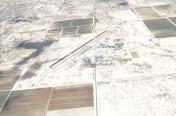
Airport Images
 from the southwest")
By: keeganm
By: Big Orange Bird


