Login
Register


RYN
Ryan Field Airport
Official FAA Data Effective 2025-12-25 0901Z
Chart Supplement

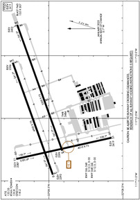
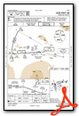
KRYN Airport Diagram
VFR Chart of KRYN
Sectional Charts at SkyVector.com
IFR Chart of KRYN
Enroute Charts at SkyVector.com
Location Information for KRYN
Coordinates: N32°8.53' / W111°10.47'Located 10 miles SW of Tucson, Arizona on 1754 acres of land. View all Airports in Arizona.
Surveyed Elevation is 2418 feet MSL.
Operations Data
|
|
Airport Communications
| ATIS: | 133.35 (520-578-0269) |
|---|---|
| AWOS-3: | Tel. 520-578-0269 |
| RYAN TOWER: | 120.35 125.8 |
| RYAN GROUND: | 118.2 |
| TUCSON APPROACH: | 273.6 128.5 273.6 |
| TUCSON DEPARTURE: | 273.6 128.5 273.6 |
| CTAF: | 125.800 |
| ASOS at TUS (11.1 E): | 520-355-5542 |
| ATIS at TUS (11.9 E): | 123.8 |
| ATIS at DMA (14.9 E): | 270.1 |
- (TRACON_ID) U90 APCH/P & DEP/P FREQ 273.6.
- TWR FREQ WILL BE 125.8 FOR ALL RWYS EXC RWY 06L/24R WHEN STATED ON THE ATIS.
Nearby Navigation Aids
|
| ||||||||||||||||||||||||||||||||||||||||||||||||


Runway 06R/24L
| Dimensions: | 5500 x 75 feet / 1676 x 23 meters | |
|---|---|---|
| Surface: | Asphalt in Good Condition | |
| Weight Limits: | S-12, D-30 | |
| Edge Lighting: | Medium Intensity | |
| Runway 06R | Runway 24L | |
| Coordinates: | N32°8.41' / W111°10.76' | N32°8.71' / W111°9.75' |
| Elevation: | 2398.7 | 2403.0 |
| Traffic Pattern: | Right | |
| Runway Heading: | 70° True | 250° True |
| Markings: | Precision Instrument in good condition. | Basic in good condition. |
| Glide Slope Indicator | P4L (3.00° Glide Path Angle) | V4L (3.00° Glide Path Angle) |
| REIL: | Yes | |
Runway 06L/24R
CLSD WHEN ATCT CLSD. | ||
| Dimensions: | 4900 x 75 feet / 1494 x 23 meters | |
|---|---|---|
| Surface: | Asphalt in Good Condition | |
| Weight Limits: | S-12, D-30 | |
| Edge Lighting: | Medium Intensity | |
| Runway 06L | Runway 24R | |
| Coordinates: | N32°8.47' / W111°10.95' | N32°8.75' / W111°10.06' |
| Elevation: | 2393.1 | 2396.4 |
| Traffic Pattern: | Right | |
| Runway Heading: | 70° True | 250° True |
| Markings: | Basic in good condition. | Basic in good condition. |
| Glide Slope Indicator | P4L (3.00° Glide Path Angle) | P4L (3.00° Glide Path Angle) PAPI UNUSBL BYD 4.9 NM. |
| REIL: | Yes | |
Runway 15/33
| Dimensions: | 4010 x 75 feet / 1222 x 23 meters | |
|---|---|---|
| Surface: | Asphalt in Fair Condition | |
| Edge Lighting: | Medium Intensity | |
| Runway 15 | Runway 33 | |
| Coordinates: | N32°8.72' / W111°10.82' | N32°8.08' / W111°10.66' |
| Elevation: | 2386.7 | 2418.8 |
| Traffic Pattern: | Right | |
| Runway Heading: | 168° True | 348° True |
| Markings: | Basic in good condition. | Basic in good condition. |
Services Available
| Fuel: | 100LL (blue), Jet-A |
|---|---|
| Transient Storage: | Tiedowns |
| Airframe Repair: | MAJOR |
| Engine Repair: | MAJOR |
| Bottled Oxygen: | NOT AVAILABLE |
| Bulk Oxygen: | NOT AVAILABLE |
| Other Services: | PILOT INSTRUCTION,AIRCRAFT RENTAL |
Ownership Information
| Ownership: | Publicly owned | |
|---|---|---|
| Owner: | CITY OF TUCSON ARPT AUTHORITY | |
| 7250 S. TUCSON BLVD. SUITE 300 | ||
| TUCSON, AZ 85756 | ||
| 520-573-8100 | ||
| Manager: | DANETTE BEWLEY | |
| 7250 S. TUCSON BLVD, SUITE 300 | ||
| TUCSON, AZ 85756 | ||
| 520-573-8100 | 520-245-5766; 520-573-8188/8179/8108. | |
Other Remarks
- RWY 06L & 06R CALM WIND RWY; AFTN WIND MAY FAVOR RWY 24L & 24R.
- USE LNDG LGTS IN PAT.
- FOR CD WHEN ATCT IS CLSD CTC TUCSON APCH AT 520-829-6121.
- FQT ILS PRACTICE APCHS.
- 0LL SELF SVC H24 WITH CREDIT CARD.
- 0800-1700; AFT HR SVC FEE - 520-744-7474.
- WHEN ATCT CLSD ACTVT PAPI RWY 06R, 06L, & 24R; VASI RWY 24L; MIRL RWY 06R/24L & 15/33 - CTAF.
Weather Minimums
Instrument Approach Procedure (IAP) Charts
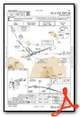

Departure Procedure Obstacles (DPO) Charts

Nearby Airports with Instrument Procedures
| ID | Name | Heading / Distance | ||
|---|---|---|---|---|
 |
KTUS | Tucson International Airport | 097° | 12.0 |
|
KDMA | Davis Monthan AFB Airport | 084° | 14.9 |
|
KAVQ | Marana Regional Airport | 352° | 16.2 |
|
KOLS | Nogales International Airport | 158° | 46.5 |
|
P08 | Coolidge Municipal Airport | 345° | 49.2 |
|
KFHU | Sierra Vista Municipal-Libby AAF Airport | 127° | 53.8 |
|
KCGZ | Casa Grande Municipal Airport | 328° | 57.2 |
|
P33 | Cochise County Airport | 084° | 65.5 |
|
KIWA | Mesa Gateway Airport | 340° | 73.9 |
|
KCHD | Chandler Municipal Airport | 334° | 74.8 |
|
P13 | San Carlos Apache Airport | 019° | 76.9 |
|
P19 | Stellar Airpark Airport | 331° | 78.8 |
Airport Images
 from the south")
By: keeganm

By: seeds007


