Login
Register


EPM
Eastport Municipal Airport
Official FAA Data Effective 2026-02-19 0901Z
Chart Supplement

VFR Chart of KEPM
Sectional Charts at SkyVector.com
IFR Chart of KEPM
Enroute Charts at SkyVector.com
Location Information for KEPM
Coordinates: N44°54.61' / W67°0.76'Located 01 miles W of Eastport, Maine on 252 acres of land. View all Airports in Maine.
Surveyed Elevation is 45 feet MSL.
Operations Data
|
|
Airport Communications
| AWOS-AV: | 122.8 Tel. 207-853-0682 |
|---|---|
| CTAF: | 122.800 |
| UNICOM: | 122.800 |
| AWOS-AV at MVM (23.4 SW): | 122.8 207-255-2511 |
| AWOS-AV at PNN (29.2 NW): | 122.7 |
| AWOS-3PT at BHB (63.9 SW): | 118.35 207-667-7364 |
- APCH/DEP SVC PRVDD BY BOSTON ARTCC ON FREQ 124.25/290.50 (BANGOR RCAG).
Nearby Navigation Aids
|
| ||||||||||||||||||||||||||||||||||||||||||||||||


Runway 14/32
| Dimensions: | 4002 x 75 feet / 1220 x 23 meters | |
|---|---|---|
| Surface: | Asphalt in Good Condition | |
| Weight Limits: | S-30 | |
| Edge Lighting: | Medium Intensity | |
| Runway 14 | Runway 32 | |
| Coordinates: | N44°54.80' / W67°1.13' | N44°54.41' / W67°0.39' |
| Elevation: | 34.6 | 45.2 |
| Traffic Pattern: | Left | Left |
| Runway Heading: | 127° True | 307° True |
| Markings: | Non-Precision Instrument in good condition. | Non-Precision Instrument in good condition. |
| Glide Slope Indicator | P2L (3.10° Glide Path Angle) PAPI UNUSBL BYD 6 DEGS L OF CNTRLN. | P2L (3.28° Glide Path Angle) |
| REIL: | Yes | Yes |
| Obstacles: | 12 ft Tree 205 ft from runway, 75 ft left of center CTLG OBSTN EXCEEDS A 45 DEG SLP. 3-5 FT BRUSH 20-200 FT FM THR, 100-200 FT R OF CNTRLN; 8 FT BERM 0-125 FT FM THR, 190 FT R OF CNTRLNE; 6-8 FT BRUSH, 100-200 FT FM THR, 65-200 FT L CNTRLN. |
3-9 FT WEEDS AND GRASS 100-200 FT FM THR, 75-250 FT R OF CNTRLN; 2-5 FT RISING TERRAIN 50-120 FT FM THR, 125 FT L OF CNTRLN. |
Services Available
| Fuel: | 100LL (blue), Jet A+ |
|---|---|
| Transient Storage: | Tiedowns 5 ACFT PRKG PADS AVBL ON APN. |
| Airframe Repair: | MAJOR |
| Engine Repair: | MAJOR |
| Bottled Oxygen: | NONE |
| Bulk Oxygen: | NONE |
Ownership Information
| Ownership: | Publicly owned | |
|---|---|---|
| Owner: | CITY OF EASTPORT | |
| 22 WASHINGTON ST | ||
| EASTPORT, ME 04631 | ||
| 207-853-2300 | ||
| Manager: | PETE LEHMANN | |
| 1 AIRPORT RD | ||
| EASTPORT, ME 04631 | ||
| 207-214-4751 | ||
Other Remarks
- DEER & NMRS BIRDS ON & INVOF RWY.
- REQ CUST AT 207-853-4313.
- 24 HR SELF-SVC FUEL AVBL WITH CREDIT CARD.
- 40-50 FT OBSTN LGTS ON POLES 250 FT R OF CNTRLN NEAR RWY 14 END & APCH AREA.
- FOR CD CTC BOSTON ARTCC AT 603-879-6859.
- JET-A FUEL PUMP LMTD TO OVR WING GRAVITY RFLG OPS.
- CONTACT AIRPORT MANAGER AT 207-214-4751
- ACTVT REIL RWY 14 & 32; PAPI RWY 14 & 32; MIRL RWY 14/32- 2 CLICKS - CTAF.
Weather Minimums

Instrument Approach Procedure (IAP) Charts


Nearby Airports with Instrument Procedures
| ID | Name | Heading / Distance | ||
|---|---|---|---|---|
 |
KMVM | Machias Valley Airport | 238° | 23.5 |
|
KPNN | Princeton Municipal Airport | 306° | 29.2 |
|
43B | Deblois Flight Strip Airport | 255° | 43.2 |
|
CYSJ | St John Airport | 062° | 53.6 |
|
KBHB | Hancock County/Bar Harbor Airport | 244° | 64.0 |
|
KLRG | Lincoln Regional Airport | 293° | 70.1 |
|
KOLD | Dewitt Field/Old Town Municipal Airport | 272° | 70.9 |
|
CYQI | Yarmouth Airport | 148° | 76.2 |
|
KBGR | Bangor International Airport | 266° | 77.7 |
|
KHUL | Houlton International Airport | 335° | 80.0 |
|
KMLT | Millinocket Municipal Airport | 302° | 83.6 |
|
KBST | Belfast Municipal Airport | 251° | 90.7 |
Airport Images
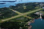
By: len.emery


