Login
Register
HUL
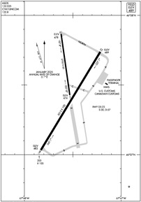
Houlton International Airport
Official FAA Data Effective 2025-11-27 0901Z
VFR Chart of KHUL
Sectional Charts at SkyVector.com
IFR Chart of KHUL
Enroute Charts at SkyVector.com
Location Information for KHUL
Coordinates: N46°7.48' / W67°47.54'Located 02 miles E of Houlton, Maine on 1615 acres of land. View all Airports in Maine.
Surveyed Elevation is 489 feet MSL.
Operations Data
|
|
Airport Communications
| ASOS: | 132.025 Tel. 207-532-1584 |
|---|---|
| UNICOM: | 122.800 |
| CTAF: | 122.800 |
| AWOS-3PT at PQI (35.2 N): | 118.025 207-764-7248 |
| ASOS at CAR (45.7 N): | 135.125 207-544-7089 |
| ASOS at MLT (47.0 SW): | 135.225 207-723-8396 |
- APCH/DEP SVC PRVDD BY BOSTON ARTCC ON FREQ 120.25/346.4 (HOULTON RCAG).
Nearby Navigation Aids
|
| ||||||||||||||||||||||||||||||||||||||||||
Runway 05/23
| Dimensions: | 5015 x 100 feet / 1529 x 30 meters | |
|---|---|---|
| Surface: | Asphalt / Grooved in Good Condition | |
| Weight Limits: | S-30, D-57 | |
| Edge Lighting: | Medium Intensity | |
| Runway 05 | Runway 23 | |
| Coordinates: | N46°7.03' / W67°47.83' | N46°7.74' / W67°47.22' |
| Elevation: | 483.0 | 489.3 |
| Traffic Pattern: | Left | Left |
| Runway Heading: | 31° True | 211° True |
| Markings: | Non-Precision Instrument in good condition. | Non-Precision Instrument in good condition. |
| Glide Slope Indicator | P4L (3.00° Glide Path Angle) | |
| REIL: | Yes | Yes |
Runway 01/19
| Dimensions: | 2700 x 60 feet / 823 x 18 meters | |
|---|---|---|
| Surface: | Asphalt in Good Condition | |
| Runway 01 | Runway 19 | |
| Coordinates: | N46°7.43' / W67°47.53' | N46°7.87' / W67°47.62' |
| Elevation: | 473.8 | 477.8 |
| Runway Heading: | 352° True | 172° True |
| Markings: | Basic in poor condition. | Basic in poor condition. |
Services Available
| Fuel: | 100LL (blue), Jet A+, Jet A-1+ |
|---|---|
| Transient Storage: | Hangars,Tiedowns |
| Airframe Repair: | MAJOR |
| Engine Repair: | MAJOR |
| Bottled Oxygen: | NONE |
| Bulk Oxygen: | NONE |
| Other Services: | AIR AMBULANCE SERVICES |
Ownership Information
| Ownership: | Publicly owned | |
|---|---|---|
| Owner: | TOWN OF HOULTON | |
| 21 WATER STREET | ||
| HOULTON, ME 04730 | ||
| 207-532-7111 | ||
| Manager: | CHRISTOPHER STEWART | ALTN: 207-538-7997. |
| 21 WATER ST. | ||
| HOULTON, ME 04730 | ||
| (207) 532-1325 | ||
Other Remarks
- USDA RECATERING FAC AVBL.
- DEER ON & INVOF ARPT.
- FOR AFT HRS ACES TO TRML BLDG USE FREQ 122.8.
- FOR CD IF UNA TO CTC ON FSS FREQ, CTC BOSTON ARTCC AT 603-879-6859 .
- FADED.
- FADED.
- 0LL FOR JET A FUEL AFT HRS CALL 207-538-7997. 100 LL IS AVBL 24 HRS WITH MAJOR CREDIT CARD.
- DUSK-DAWN. ACTVT REIL RWY 05 & 23; PAPI RWY 05; MIRL RWY 05/23 - CTAF.
Weather Minimums
Instrument Approach Procedure (IAP) Charts
Nearby Airports with Instrument Procedures
| ID | Name | Heading / Distance | ||
|---|---|---|---|---|
 |
KPQI | Presque Isle International Airport | 342° | 35.5 |
 |
KCAR | Caribou Municipal Airport | 348° | 45.8 |
 |
KMLT | Millinocket Municipal Airport | 232° | 47.1 |
 |
KLRG | Lincoln Regional Airport | 214° | 55.4 |
 |
KPNN | Princeton Municipal Airport | 170° | 56.3 |
 |
KFVE | Northern Aroostook Regional Airport | 343° | 72.9 |
 |
KOLD | Dewitt Field/Old Town Municipal Airport | 208° | 79.6 |
 |
KEPM | Eastport Municipal Airport | 155° | 80.0 |
 |
3B1 | Greenville Municipal Airport | 242° | 83.9 |
 |
43B | Deblois Flight Strip Airport | 185° | 84.3 |
 |
52B | Moosehead Aero Marine Seaplane Base | 243° | 85.5 |
 |
KMVM | Machias Valley Airport | 171° | 86.3 |


