Login
Register


EZZ
Cameron Memorial Airport
Official FAA Data Effective 2026-02-19 0901Z
Chart Supplement

VFR Chart of KEZZ
Sectional Charts at SkyVector.com
IFR Chart of KEZZ
Enroute Charts at SkyVector.com
Location Information for KEZZ
Coordinates: N39°43.65' / W94°16.58'Located 02 miles SW of Cameron, Missouri on 202 acres of land. View all Airports in Missouri.
Surveyed Elevation is 1040 feet MSL.
Operations Data
|
|
Airport Communications
| AWOS-3PT: | 121.05 Tel. 816-933-2124 |
|---|---|
| KANSAS CITY APPROACH: | 118.4 307.35 |
| KANSAS CITY DEPARTURE: | 118.4 307.35 |
| CLEARANCE DELIVERY: | 121.6 |
| UNICOM: | 122.800 |
| CTAF: | 122.800 |
| AWOS-3P at GPH (23.8 S): | 120.275 816-407-3399 |
| ASOS at STJ (29.4 W): | 125.05 816-233-0666 |
| ATIS at STJ (29.4 W): | 125.05 |
Nearby Navigation Aids
|
| ||||||||||||||||||||||||||||||||||||||||||||||||||||||||||||


Runway 17/35
| Dimensions: | 4000 x 75 feet / 1219 x 23 meters | |
|---|---|---|
| Surface: | Concrete in Good Condition | |
| Weight Limits: | S-30 | |
| Edge Lighting: | Medium Intensity | |
| Runway 17 | Runway 35 | |
| Coordinates: | N39°43.98' / W94°16.62' | N39°43.33' / W94°16.54' |
| Elevation: | 1040.1 | 1023.1 |
| Traffic Pattern: | Left | Left |
| Runway Heading: | 175° True | 355° True |
| Markings: | Non-Precision Instrument in good condition. | Non-Precision Instrument in good condition. |
| Glide Slope Indicator | P4L (3.00° Glide Path Angle) | P4L (3.00° Glide Path Angle) |
| REIL: | Yes | Yes |
| Obstacles: | 39 ft Trees 1234 ft from runway, 310 ft left of center | |
Services Available
| Fuel: | 100LL (blue) |
|---|---|
| Transient Storage: | Hangars,Tiedowns |
| Airframe Repair: | NOT AVAILABLE |
| Engine Repair: | NOT AVAILABLE |
| Bottled Oxygen: | NOT AVAILABLE |
| Bulk Oxygen: | NOT AVAILABLE |
| Other Services: | PILOT INSTRUCTION,AIRCRAFT RENTAL,AIRCRAFT SALES |
Ownership Information
| Ownership: | Publicly owned | |
|---|---|---|
| Owner: | CITY OF CAMERON | |
| 205 NORTH MAIN | ||
| CAMERON, MO 64429 | ||
| 816-632-2177 | ||
| Manager: | ERIC EVANS | |
| 11766 NORTHEAST A HWY | ||
| CAMERON, MO 64429 | ||
| 816-632-2423 | ||
Other Remarks
- FOR CD CTC KANSAS CITY APCH AT 816-329-2710.
- 0LL AUTOMATED SELF FUEL AVBL 24 HRS.
- MIRL RY 17/35, PAPI RYS 17 & 35, REIL RYS 17 & 35 OPER DUSK-2400; AFT 2400 ACTVT & INCR INTS - CTAF.
Weather Minimums

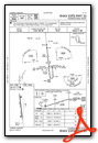
Instrument Approach Procedure (IAP) Charts

Nearby Airports with Instrument Procedures
| ID | Name | Heading / Distance | ||
|---|---|---|---|---|
 |
3EX | Excelsior Springs Memorial Airport | 171° | 23.7 |
|
KGPH | Midwest Ntl Air Center Airport | 183° | 23.7 |
|
KSTJ | Rosecrans Memorial Airport | 275° | 29.4 |
|
KMCI | Kansas City International Airport | 218° | 32.8 |
|
KCHT | Chillicothe Municipal Airport | 084° | 36.2 |
|
KFLV | Sherman AAF Airport | 234° | 36.6 |
|
KTRX | Trenton Municipal Airport | 055° | 38.2 |
|
KMKC | Kansas City Downtown/Wheeler Field Airport | 202° | 39.1 |
|
K59 | Amelia Earhart Airport | 257° | 42.9 |
|
3GV | East Kansas City Airport | 176° | 42.8 |
|
KLXT | Kansas City/Lee's Summit Regional Airport | 185° | 46.3 |
|
KEVU | Northwest Missouri Regional Airport | 322° | 47.7 |
Airport Images
Do you have a recent image of this airport? Upload it here!


