Login
Register


GPH
Midwest Ntl Air Center Airport
Official FAA Data Effective 2026-01-22 0901Z
Chart Supplement

VFR Chart of KGPH
Sectional Charts at SkyVector.com
IFR Chart of KGPH
Enroute Charts at SkyVector.com
Location Information for KGPH
Coordinates: N39°19.95' / W94°18.58'Located 01 miles N of Mosby, Missouri on 573 acres of land. View all Airports in Missouri.
Surveyed Elevation is 777 feet MSL.
Operations Data
|
|
Airport Communications
| AWOS-3P: | 120.275 Tel. 816-407-3399 |
|---|---|
| KANSAS CITY APPROACH: | 118.4 307.35 |
| KANSAS CITY DEPARTURE: | 118.4 307.35 |
| CLEARANCE DELIVERY: | 118.2 |
| BRAYMER STAR: | 120.95 318.1 |
| JHAWK STAR: | 120.95 318.1 |
| TYGER STAR: | 120.95 318.1 |
| UNICOM: | 122.700 |
| CTAF: | 122.700 |
| ASOS at MKC (17.9 SW): | 120.75 816-329-2843 |
| ATIS at MKC (18.2 SW): | 120.75 |
| ASOS at MCI (18.8 W): | 816-601-1486 |
Nearby Navigation Aids
|
| ||||||||||||||||||||||||||||||||||||||||||||||||||||||||||||


Runway 18/36
| Dimensions: | 5502 x 100 feet / 1677 x 30 meters | |
|---|---|---|
| Surface: | Asphalt in Good Condition | |
| Weight Limits: | 156/F/D/X/T, S-30, D-60
156 IS PCR.
| |
| Edge Lighting: | High Intensity | |
| Runway 18 | Runway 36 | |
| Coordinates: | N39°20.40' / W94°18.51' | N39°19.50' / W94°18.65' |
| Elevation: | 777.1 | 774.8 |
| Traffic Pattern: | Left | |
| Runway Heading: | 187° True | 7° True |
| Markings: | Precision Instrument in good condition. | Non-Precision Instrument in good condition. |
| Glide Slope Indicator | P4L (3.50° Glide Path Angle) | P4L (3.00° Glide Path Angle) |
| REIL: | Yes | Yes |
Services Available
| Fuel: | 100LL (blue), Jet A+ |
|---|---|
| Transient Storage: | Hangars,Tiedowns |
| Airframe Repair: | NOT AVAILABLE |
| Engine Repair: | NOT AVAILABLE |
| Bottled Oxygen: | NOT AVAILABLE |
| Bulk Oxygen: | NOT AVAILABLE |
Ownership Information
| Ownership: | Publicly owned | |
|---|---|---|
| Owner: | CLAY COUNTY COMMISSION | |
| 1 COURTHOUSE SQUARE | ||
| LIBERTY, MO 64068 | ||
| 816-407-3390 | ||
| Manager: | DONNA KOONTZ | |
| 13106 RHODUS RD | ||
| EXCELSIOR SPRINGS, MO 64024 | ||
| 816-407-3396 | ||
Other Remarks
- ARPT TERMINAL BLDG OPEN 24 HRS.
- CONFIRM SNOW REMOVAL AND WINTER CONDITIONS DURING NOV-MAR, CALL 816-407-3390.
- FLOCKS OF DUCKS; GEESE & OTHER WILDLIFE ON AND INVOF ARPT.
- FOR CD CTC KANSAS CITY APCH AT 816-329-2710.
- 24 HR CREDIT CARD FUELING SYSTEM AVBL FOR JET-A & 100LL. FOR AFTER HRS FULL SVC FUELING CALL 816-407-3390. AFTER HRS CALL OUT FEE WAIVED WITH 200 GAL OR MORE FUEL PURCHASE.
- ACTVT HIRL RY 18/36; PAPI RYS 18 & 36; REIL RYS 18 & 36 - CTAF.
Weather Minimums


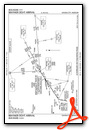
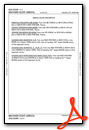
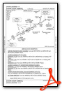
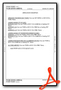
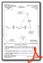
Standard Terminal Arrival (STAR) Charts

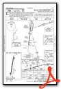
Instrument Approach Procedure (IAP) Charts


Departure Procedure (DP) Charts


Nearby Airports with Instrument Procedures
| ID | Name | Heading / Distance | ||
|---|---|---|---|---|
 |
3EX | Excelsior Springs Memorial Airport | 086° | 5.2 |
|
KMKC | Kansas City Downtown/Wheeler Field Airport | 226° | 18.2 |
|
KMCI | Kansas City International Airport | 263° | 18.9 |
|
3GV | East Kansas City Airport | 166° | 19.6 |
|
KLXT | Kansas City/Lee's Summit Regional Airport | 187° | 22.6 |
|
KEZZ | Cameron Memorial Airport | 003° | 23.7 |
|
KFLV | Sherman AAF Airport | 274° | 28.2 |
|
KHIG | Higginsville Industrial Municipal Airport | 117° | 33.4 |
|
KOJC | Johnson County Exec Airport | 214° | 35.3 |
|
KSTJ | Rosecrans Memorial Airport | 313° | 38.3 |
|
KIXD | New Century Aircenter Airport | 222° | 40.5 |
|
KRCM | Skyhaven Airport | 144° | 40.5 |
Fuel Providers

Airport Images
Do you have a recent image of this airport? Upload it here!


