Login
Register


HHW
Stan Stamper Municipal Airport
Official FAA Data Effective 2026-01-22 0901Z
Chart Supplement

VFR Chart of KHHW
Sectional Charts at SkyVector.com
IFR Chart of KHHW
Enroute Charts at SkyVector.com
Location Information for KHHW
Coordinates: N34°2.02' / W95°32.52'Located 02 miles NW of Hugo, Oklahoma on 167 acres of land. View all Airports in Oklahoma.
Surveyed Elevation is 572 feet MSL.
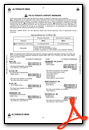
Operations Data
|
|
Airport Communications
| AWOS-3: | 119.025 Tel. 580-326-2134 |
|---|---|
| UNICOM: | 122.800 |
| CTAF: | 122.800 |
| AWOS-3PT at PRX (24.3 S): | 119.675 903-737-8784 |
| AWOS-3 at 4O4 (35.0 E): | 120.0 580-286-2217 |
| AWOS-3 at AQR (37.2 NW): | 121.125 580-889-6924 |
- APCH/DEP SVC PRVDD BY FORT WORTH ARTCC (ZFW) ON FREQS 124.875/370.95 (BONHAM RCAG).
Nearby Navigation Aids
|
| ||||||||||||||||||||||||||||||||||||||||||||||||||||||||||||


Runway 17/35
| Dimensions: | 4007 x 75 feet / 1221 x 23 meters | |
|---|---|---|
| Surface: | Asphalt in Good Condition | |
| Weight Limits: | S-12 | |
| Edge Lighting: | Medium Intensity | |
| Runway 17 | Runway 35 | |
| Coordinates: | N34°2.35' / W95°32.52' | N34°1.69' / W95°32.52' |
| Elevation: | 567.1 | 572.2 |
| Runway Heading: | 180° True | 0 |
| Markings: | Non-Precision Instrument in good condition. | Non-Precision Instrument in good condition. |
| Glide Slope Indicator | P2L (3.00° Glide Path Angle) | P2L (3.00° Glide Path Angle) |
| REIL: | Yes | Yes |
| Obstacles: | 35 ft Trees 380 ft from runway, 195 ft right of center | 18 FT TREE 198 FT FM RWY 35 END 185 FT LEFT OF RWY 35 APCH. |
Services Available
| Fuel: | 100LL (blue), Jet A+ |
|---|---|
| Transient Storage: | Tiedowns |
| Airframe Repair: | NONE |
| Engine Repair: | NONE |
| Bottled Oxygen: | NONE |
| Bulk Oxygen: | NONE |
| Other Services: | AIR AMBULANCE SERVICES |
Ownership Information
| Ownership: | Publicly owned | |
|---|---|---|
| Owner: | CITY OF HUGO | |
| 201 S SECOND ST | ||
| HUGO, OK 74743 | ||
| 580-326-2344 | ||
| Manager: | STEVE HOLMAN | |
| 858 N. 4210 RD. | ||
| HUGO, OK 74743 | ||
| 580-317-3513 | ||
Other Remarks
- FOR CD CTC FORT WORTH ARTCC AT 817-858-7584.
- 0LL FUEL AVBL 24 HR SELF SERVICE WITH MAJOR CREDIT CARD.
- ACTVT MIRL RWY 17/35, REILS RWY 17/35- CTAF.
Weather Minimums

Instrument Approach Procedure (IAP) Charts
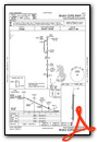
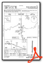
Nearby Airports with Instrument Procedures
| ID | Name | Heading / Distance | ||
|---|---|---|---|---|
 |
80F | Antlers Municipal Airport | 330° | 11.0 |
|
KPRX | Cox Field Airport | 169° | 24.2 |
|
4O4 | Mc Curtain County Regional Airport | 102° | 34.9 |
|
F00 | Jones Field Airport | 231° | 40.6 |
|
KDUA | Durant Regional/Eaker Field Airport | 262° | 42.9 |
|
2F7 | Commerce Municipal Airport | 201° | 47.8 |
|
F53 | Franklin County Airport | 162° | 51.3 |
|
KMLC | Mc Alester Regional Airport | 346° | 52.2 |
|
KSLR | Sulphur Springs Municipal Airport | 184° | 52.5 |
|
KDEQ | J Lynn Helms Sevier County Airport | 088° | 57.0 |
|
KSWI | Sherman Municipal Airport | 245° | 57.7 |
|
KGYI | North Texas Regional/Perrin Field Airport | 251° | 59.7 |
Airport Images
Do you have a recent image of this airport? Upload it here!


