Login
Register


F49
City of Slaton/Larry T Neal Memorial Airport
Official FAA Data Effective 2025-11-27 0901Z
Chart Supplement

VFR Chart of F49
Sectional Charts at SkyVector.com
IFR Chart of F49
Enroute Charts at SkyVector.com
Location Information for F49
Coordinates: N33°29.11' / W101°39.70'Located 02 miles N of Slaton, Texas on 320 acres of land. View all Airports in Texas.
Surveyed Elevation is 3126 feet MSL.
Operations Data
|
|
Airport Communications
| LUBBOCK APPROACH: | 119.2 351.8 |
|---|---|
| LUBBOCK DEPARTURE: | 119.2 351.8 |
| CTAF: | 123.000 |
| UNICOM: | 123.000 |
| ASOS at LBB (13.3 NW): | 806-766-6432 |
| ATIS at LBB (13.3 NW): | 125.3 |
| AWOS-3PT at LLN (36.0 W): | 121.125 806-897-4770 |
Nearby Navigation Aids
|
| ||||||||||||||||||||||||||||||||||||||||||


Runway 18/36
| Dimensions: | 4244 x 75 feet / 1294 x 23 meters | |
|---|---|---|
| Surface: | Asphalt in Good Condition | |
| Weight Limits: | S-20 | |
| Edge Lighting: | Medium Intensity | |
| Runway 18 | Runway 36 | |
| Coordinates: | N33°29.40' / W101°39.60' | N33°28.71' / W101°39.72' |
| Elevation: | 3122.8 | 3112.6 |
| Traffic Pattern: | Left | Left |
| Runway Heading: | 188° True | 8° True |
| Markings: | Non-Precision Instrument in good condition. | Non-Precision Instrument in good condition. |
| Glide Slope Indicator | P2L (3.00° Glide Path Angle) PAPI OTS INDEFLY. | P2L (3.00° Glide Path Angle) PAPI OTS INDEFLY. |
| Obstacles: | 23 ft Pole 762 ft from runway, 258 ft right of center | |
Runway 08/26
| Dimensions: | 1720 x 65 feet / 524 x 20 meters | |
|---|---|---|
| Surface: | Turf in Poor Condition RWY SFC ROUGH. | |
| Runway 08 | Runway 26 | |
| Coordinates: | N33°29.25' / W101°39.97' | N33°29.27' / W101°39.64' |
| Elevation: | 3126.5 | 3122.5 |
| Runway Heading: | 86° True | 266° True |
| Markings: | None | None |
| Obstacles: | 6 ft Brush 57 ft from runway | |
Services Available
| Fuel: | 100LL (blue), Jet-A |
|---|---|
| Transient Storage: | Hangars,Tiedowns |
| Airframe Repair: | MINOR |
| Engine Repair: | MINOR |
| Bottled Oxygen: | NOT AVAILABLE |
| Bulk Oxygen: | NOT AVAILABLE |
| Other Services: | CROP DUSTING SERVICES,PILOT INSTRUCTION |
Ownership Information
| Ownership: | Publicly owned | |
|---|---|---|
| Owner: | CITY OF SLATON | |
| 130 S 9TH ST | ||
| SLATON, TX 79364 | ||
| 806-828-2000 | ||
| Manager: | ROBERT NEAL | F.B.O. LESEE. |
| 12106 FM 400 | ||
| SLATON, TX 79364 | ||
| 806-828-5892 | ||
Other Remarks
- ACFT NOT VSB FM OPPSITE ENDS OF RWY.
- AEROBATIC ACTVT SR-SS, MOD USE ON WKENDS.
- FOR CD CTC FORT WORTH ARTCC AT 817-858-7584.
- 3457 FT MSL, 348 FT AGL TWR, 1.75 NM SW OF ARPT.
- RWY 08/26 CLSD PERMLY.
- MIRL RWY 18/36 NONSTD PCL: 3-X ON, 5-X OFF - CTAF.
Weather Minimums

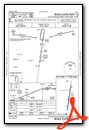
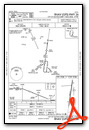
Instrument Approach Procedure (IAP) Charts
Nearby Airports with Instrument Procedures
| ID | Name | Heading / Distance | ||
|---|---|---|---|---|
 |
F82 | Lubbock Exec Airpark Airport | 269° | 7.6 |
|
KLBB | Lubbock Preston Smith International Airport | 323° | 13.3 |
|
8F3 | Crosbyton Municipal Airport | 068° | 22.7 |
|
KBFE | Terry County Airport | 235° | 32.6 |
|
41F | Floydada Municipal Airport | 028° | 35.1 |
|
KLLN | Levelland Municipal Airport | 276° | 35.9 |
|
KPVW | Hale County Airport | 356° | 41.0 |
|
KLIU | Littlefield Taylor Brown Municipal Airport | 306° | 44.8 |
|
KLUV | Lamesa Municipal Airport | 196° | 45.6 |
|
KSNK | Winston Field Airport | 142° | 59.4 |
|
F98 | Yoakum County Airport | 255° | 60.9 |
|
2T1 | Muleshoe Municipal Airport | 310° | 64.4 |
Airport Images
Do you have a recent image of this airport? Upload it here!


