Login
Register


LBB
Lubbock Preston Smith International Airport
Official FAA Data Effective 2026-02-19 0901Z
Chart Supplement

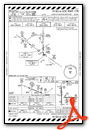
KLBB Airport Diagram

VFR Chart of KLBB
Sectional Charts at SkyVector.com
IFR Chart of KLBB
Enroute Charts at SkyVector.com
Location Information for KLBB
Coordinates: N33°39.82' / W101°49.23'Located 04 miles N of Lubbock, Texas on 3000 acres of land. View all Airports in Texas.
Surveyed Elevation is 3282 feet MSL.
Operations Data
|
|
Airport Communications
| ATIS: | 125.3 (806-766-6404) 270.275 (806-766-6404) |
|---|---|
| ASOS: | Tel. 806-766-6432 |
| LUBBOCK TOWER: | 120.5 239.3 |
| LUBBOCK GROUND: | 121.9 348.6 |
| LUBBOCK APPROACH: | 119.2 119.9 279.9 335.6 351.8 |
| LUBBOCK DEPARTURE: | 119.2 119.9 124.45 269.2 335.6 351.8 |
| IC: | 119.2 351.8 |
| CLEARANCE DELIVERY: | 125.8 281.55 |
| CLASS C: | 119.2 351.8 |
| EMERG: | 121.5 |
| CLASS C/S: | 119.9 335.6 |
| UNICOM: | 122.950 |
| AWOS-3PT at LLN (28.5 W): | 121.125 806-897-4770 |
| AWOS-3 at PVW (30.7 N): | 119.675 806-291-8679 |
| AWOS-3PT at LUV (55.1 S): | 124.175 806-872-0659 |
Nearby Navigation Aids
|
| ||||||||||||||||||||||||||||||||||||||||||||||||


Runway 17R/35L
| Dimensions: | 11500 x 150 feet / 3505 x 46 meters | |
|---|---|---|
| Surface: | Concrete / Grooved in Good Condition | |
| Weight Limits: | S-100, D-170, ST-350
PCR VALUE: 965/R/B/W/T
| |
| Edge Lighting: | High Intensity | |
| Runway 17R | Runway 35L | |
| Coordinates: | N33°40.94' / W101°49.74' | N33°39.05' / W101°49.73' |
| Elevation: | 3282.4 | 3242.5 |
| Traffic Pattern: | Right | Left |
| Runway Heading: | 180° True | 360° True |
| Declared Distances: | TORA:11500 TODA:11500 ASDA:11500 LDA:11500 | TORA:11500 TODA:11500 ASDA:11500 LDA:11500 |
| Markings: | Precision Instrument in good condition. | Precision Instrument in good condition. |
| Glide Slope Indicator | P4R (3.00° Glide Path Angle) | V4L (3.00° Glide Path Angle) |
| RVR Equipment | Touchdown | Rollout |
| Approach Lights: | MALSR 1,400 Foot Medium-intensity Approach Lighting System with runway alignment indicator lights. | |
Runway 08/26
| Dimensions: | 8003 x 150 feet / 2439 x 46 meters | |
|---|---|---|
| Surface: | Concrete / Grooved in Good Condition | |
| Weight Limits: | S-100, D-170, ST-350
PCR VALUE: 1073/R/B/W/T
| |
| Edge Lighting: | High Intensity | |
| Runway 08 | Runway 26 | |
| Coordinates: | N33°39.73' / W101°49.37' | N33°39.74' / W101°47.80' |
| Elevation: | 3258.3 | 3252.6 |
| Traffic Pattern: | Right | Left |
| Runway Heading: | 89° True | 269° True |
| Declared Distances: | TORA:8003 TODA:8003 ASDA:8003 LDA:8003 | TORA:8003 TODA:8003 ASDA:8003 LDA:8003 |
| Markings: | Precision Instrument in good condition. | Precision Instrument in good condition. |
| Glide Slope Indicator | P4L (3.00° Glide Path Angle) | P4L (3.00° Glide Path Angle) |
| RVR Equipment | Rollout | Touchdown |
| Approach Lights: | MALSR 1,400 Foot Medium-intensity Approach Lighting System with runway alignment indicator lights. | |
| REIL: | Yes | |
Runway 17L/35R
RWY 17L/35R NOT AVBL FOR PART 121/PART 380 OPS WITH SKED PAX CARRYING OPS MORE THAN 9 PAX SEATS AND NON-SKED PAX CARRYING OPS MORE THAN 30 PAX SEATS. | ||
| Dimensions: | 2891 x 74 feet / 881 x 23 meters | |
|---|---|---|
| Surface: | Asphalt in Fair Condition | |
| Weight Limits: | S-12 | |
| Runway 17L | Runway 35R | |
| Coordinates: | N33°39.59' / W101°49.03' | N33°39.11' / W101°49.03' |
| Elevation: | 3254.6 | 3262.4 |
| Traffic Pattern: | Left | Right |
| Runway Heading: | 180° True | 360° True |
| Declared Distances: | TORA:2891 TODA:2891 ASDA:2891 LDA:2891 | TORA:2891 TODA:2891 ASDA:2891 LDA:2891 |
| Markings: | Basic in good condition. | Basic in good condition. |
| Obstacles: | 18 ft Road 573 ft from runway, 162 ft right of center | |
Services Available
| Fuel: | 100LL (blue), Jet-A, Jet A-1+ |
|---|---|
| Transient Storage: | Hangars,Tiedowns |
| Airframe Repair: | MAJOR |
| Engine Repair: | MAJOR |
| Bottled Oxygen: | HIGH/LOW |
| Bulk Oxygen: | HIGH/LOW |
| Other Services: | AIR FREIGHT SERVICES,AIR AMBULANCE SERVICES,AVIONICS,CHARTER SERVICE,PILOT INSTRUCTION,AIRCRAFT SALES |
Ownership Information
| Ownership: | Publicly owned | |
|---|---|---|
| Owner: | CITY OF LUBBOCK | |
| PO BOX 2000 | ||
| LUBBOCK, TX 79457 | ||
| 806-775-3000 | ||
| Manager: | KELLY CAMPBELL | |
| RT 3 BOX 389 | ||
| LUBBOCK, TX 79401 | ||
| 806-775-3126 | ||
Other Remarks
- RWY 17L/35R RSTRD TO GEN AVN ACFT 12500 LBS OR LESS.
- TWY L BTN TWY F AND TWY J CLSD TO MORE THAN 120001 LB.
- TWYS B & D, TXLS E & E1 NOT AVBL FOR PART 121/PART 380 OPS WITH SKED PAX CARRYING OPS MORE THAN 9 PAX SEATS AND NON SKED PAX CARRYING OPS MORE THAN 30 PAX SEATS.
- TWYS B & D; TXLS E & E1 RSTRD TO ACFT WEIGHING LESS THAN 50000 LBS.
- PSGR TRML RAMP ACES RSTRD TO ACRS & OTRS WITH PRIOR PMSN, CALL 806-775-2044.
- RWY 17L/35R; TWYS B & D; TXLS E & E1 NOT AVBL FOR ACR ACFT WITH OVER 9 PSGR SEATS.
- NMRS BIRDS ON & INVOF ARPT.
- EAST RAMP DELINEATED TXL & APRON AREA RSTRD TO 120000 LBS DUAL TAND ACFT; 89000 LBS DUAL SNGL WHEEL ACFT; 60000 LBS SNGL WHEEL ACFT. ALL OTR EAST RAMP PAVEMENTS RSTRD TO ACFT LESS THAN 12500 LBS SNGL WHEEL ACFT.
- PAEW ADJ RWYS 08/26 & 17R/35L.
Weather Minimums


Instrument Approach Procedure (IAP) Charts


Nearby Airports with Instrument Procedures
| ID | Name | Heading / Distance | ||
|---|---|---|---|---|
 |
F82 | Lubbock Exec Airpark Airport | 177° | 10.8 |
|
F49 | City of Slaton/Larry T Neal Memorial Airport | 143° | 13.3 |
|
KLLN | Levelland Municipal Airport | 256° | 28.4 |
|
8F3 | Crosbyton Municipal Airport | 094° | 29.1 |
|
KPVW | Hale County Airport | 009° | 30.7 |
|
41F | Floydada Municipal Airport | 050° | 31.8 |
|
KLIU | Littlefield Taylor Brown Municipal Airport | 298° | 32.3 |
|
KBFE | Terry County Airport | 212° | 34.8 |
|
2T1 | Muleshoe Municipal Airport | 307° | 51.5 |
|
KLUV | Lamesa Municipal Airport | 185° | 54.6 |
|
F98 | Yoakum County Airport | 242° | 57.3 |
|
KGNC | Gaines County Airport | 215° | 72.5 |
Fuel Providers

Airport Images
Do you have a recent image of this airport? Upload it here!


