Login
Register


FIG
Clearfield-Lawrence Airport
Official FAA Data Effective 2026-01-22 0901Z
Chart Supplement

VFR Chart of KFIG
Sectional Charts at SkyVector.com
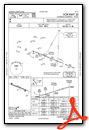
IFR Chart of KFIG
Enroute Charts at SkyVector.com
Location Information for KFIG
Coordinates: N41°2.95' / W78°24.91'Located 02 miles NE of Clearfield, Pennsylvania on 140 acres of land. View all Airports in Pennsylvania.
Estimated Elevation is 1516 feet MSL.
Operations Data
|
|
Airport Communications
| ASOS: | 119.275 Tel. 814-765-9703 |
|---|---|
| CTAF: | 122.725 |
| UNICOM: | 122.725 |
| AWOS-3 at PSB (17.9 SE): | 127.525 814-343-4531 |
| AWOS-3P at OYM (22.2 N): | 118.05 814-834-9416 |
| ASOS at DUJ (23.2 W): | 119.025 814-328-5140 |
- APCH/DEP SVC PRVDD BY NEW YORK ARTCC ON FREQS 134.8/338.3 (PHILIPSBURG RCAG).
Nearby Navigation Aids
|
| ||||||||||||||||||||||||||||||||||||||||||||||||


Runway 12/30
| Dimensions: | 4499 x 75 feet / 1371 x 23 meters | |
|---|---|---|
| Surface: | Asphalt in Good Condition | |
| Weight Limits: | S-12 | |
| Edge Lighting: | Medium Intensity | |
| Runway 12 | Runway 30 | |
| Coordinates: | N41°3.07' / W78°25.37' | N41°2.83' / W78°24.45' |
| Elevation: | 1509.6 | 1511.1 |
| Traffic Pattern: | Left | Left |
| Runway Heading: | 109° True | 289° True |
| Markings: | Non-Precision Instrument in good condition. | Non-Precision Instrument in good condition. |
| Glide Slope Indicator | P2L (3.10° Glide Path Angle) | P4L (3.00° Glide Path Angle) |
| REIL: | Yes | |
| Obstacles: | 25 ft Tree 652 ft from runway, 152 ft left of center | |
Services Available
| Fuel: | 100LL (blue), Jet-A |
|---|---|
| Transient Storage: | Hangars,Tiedowns |
| Airframe Repair: | NOT AVAILABLE |
| Engine Repair: | NOT AVAILABLE |
| Bottled Oxygen: | NONE |
| Bulk Oxygen: | NONE |
| Other Services: | AIR AMBULANCE SERVICES |
Ownership Information
| Ownership: | Publicly owned | |
|---|---|---|
| Owner: | CLEARFIELD-LAWRENCE JOINT ARPT AUTH | |
| 801 AIRPORT RD | ||
| CLEARFIELD, PA 16830 | ||
| 814-768-7710 | ||
| Manager: | JERRY KAUFIELD | |
| 801 AIRPORT RD | ||
| CLEARFIELD, PA 16830 | ||
| 814-768-7710 | ||
Other Remarks
- FOR CD CTC NEW YORK ARTCC AT 631-468-1425.
- ACTVT REIL RWY 30; PAPI RWY 12 & 30; MIRL RWY 12/30 - CTAF.
Weather Minimums

Instrument Approach Procedure (IAP) Charts


Nearby Airports with Instrument Procedures
| ID | Name | Heading / Distance | ||
|---|---|---|---|---|
 |
KPSB | Mid-State Airport | 123° | 17.9 |
|
KOYM | St Marys Municipal Airport | 349° | 22.1 |
|
KDUJ | Dubois Regional Airport | 289° | 23.3 |
|
N35 | Punxsutawney Municipal Airport | 258° | 23.9 |
|
KUNV | State College Regional Airport | 114° | 28.4 |
|
N96 | Bellefonte Airport | 109° | 28.9 |
|
9G8 | Ebensburg Airport | 205° | 38.9 |
|
KIDI | Indiana County/Jimmy Stewart Field Airport | 231° | 40.1 |
|
KRVL | Mifflin County Airport | 121° | 42.2 |
|
KLHV | William T Piper Memorial Airport | 083° | 45.3 |
|
KAOO | Altoona/Blair County Airport | 174° | 45.3 |
|
KBFD | Bradford Regional Airport | 347° | 46.3 |
Airport Images
Do you have a recent image of this airport? Upload it here!


