Login
Register
FSD
Joe Foss Field Airport
Official FAA Data Effective 2025-12-25 0901Z
VFR Chart of KFSD
Sectional Charts at SkyVector.com
IFR Chart of KFSD
Enroute Charts at SkyVector.com
Location Information for KFSD
Coordinates: N43°34.92' / W96°44.52'Located 03 miles NW of Sioux Falls, South Dakota on 1570 acres of land. View all Airports in South Dakota.
Surveyed Elevation is 1430 feet MSL.
Operations Data
|
|
Airport Communications
| ATIS: | 126.6 |
|---|---|
| ASOS: | Tel. 605-204-9608 |
| SIOUX FALLS TOWER: | 118.3 257.8 |
| SIOUX FALLS GROUND: | 121.9 348.6 |
| SIOUX FALLS APPROACH: | 125.8 126.9 284.725 353.6 |
| SIOUX FALLS DEPARTURE: | 125.8 126.9 284.725 353.6 |
| EMERG: | 121.5 243.0 |
| OPS: | 390.1 ;BASE MAINT |
| CTAF: | 118.300 |
| COMD POST: | 138.25 253.4 36.85FM |
| UNICOM: | 122.950 |
| AWOS-3 at LYV (22.9 E): | 119.825 507-283-5027 |
| AWOS-3 at MDS (30.0 NW): | 118.35 605-427-9380 |
| AWOS-3PT at PQN (30.7 NE): | 118.375 507-825-6895 |
- APCH/DEP SVC PRVDD BY MINNEAPOLIS ARTCC ON FREQ 132.050/317.4 (SIOUX FALLS RCAG) WHEN SIOUX FALLS APCH CTL IS CLSD.
- BASE COMMAND POST CALL (CLARENCE 49).
Nearby Navigation Aids
|
| ||||||||||||||||||||||||||||||||||||||||||||||||||||||||||||
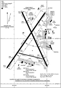
Runway 03/21
| Dimensions: | 9000 x 150 feet / 2743 x 46 meters | |
|---|---|---|
| Surface: | Concrete / Grooved in Good Condition | |
| Weight Limits: | 60 /R/B/W/T, S-200, D-200, ST-444 | |
| Edge Lighting: | High Intensity | |
| Runway 03 | Runway 21 | |
| Coordinates: | N43°34.36' / W96°45.22' | N43°35.57' / W96°44.06' |
| Elevation: | 1423.5 | 1430.0 |
| Traffic Pattern: | Left | Left |
| Runway Heading: | 35° True | 215° True |
| Declared Distances: | TORA:8999 TODA:8999 ASDA:8999 LDA:8999 | TORA:8999 TODA:8999 ASDA:8999 LDA:8999 |
| Markings: | Precision Instrument in good condition. | Precision Instrument in good condition. |
| Glide Slope Indicator | P4L (3.00° Glide Path Angle) | P4L (3.00° Glide Path Angle) |
| RVR Equipment | Touchdown | Touchdown |
| Approach Lights: | MALSR 1,400 Foot Medium-intensity Approach Lighting System with runway alignment indicator lights. | MALSR 1,400 Foot Medium-intensity Approach Lighting System with runway alignment indicator lights. |
| Centerline Lights: | Yes | Yes |
| Obstacles: | 8 ft Road 283 ft from runway, 511 ft left of center | 27 ft Railroad 1178 ft from runway, 645 ft right of center |
Runway 15/33
| Dimensions: | 8000 x 150 feet / 2438 x 46 meters | |
|---|---|---|
| Surface: | Concrete / Grooved in Good Condition | |
| Weight Limits: | 70 /R/B/W/T, S-100, D-180, ST-400 | |
| Edge Lighting: | High Intensity | |
| Runway 15 | Runway 33 | |
| Coordinates: | N43°35.59' / W96°44.76' | N43°34.39' / W96°44.00' |
| Elevation: | 1429.2 | 1422.4 |
| Traffic Pattern: | Left | Left |
| Runway Heading: | 155° True | 335° True |
| Declared Distances: | TORA:8000 TODA:8000 ASDA:8000 LDA:8000 | TORA:8000 TODA:8000 ASDA:8000 LDA:8000 |
| Markings: | Non-Precision Instrument in good condition. | Non-Precision Instrument in good condition. |
| Glide Slope Indicator | P4L (3.00° Glide Path Angle) PAPI UNUSBL BYD 6 DEGS LEFT AND 5 DEGS RIGHT OF CNTRLN. | P4L (3.00° Glide Path Angle) PAPI UNUSBL BYD 9 DEGS RIGHT OF CNTRLN. |
| REIL: | Yes | Yes |
| Obstacles: | 109 ft Tree 3786 ft from runway, 702 ft right of center ALSO LGTD TWR; 4962 FM RY END; 159 ABV RY END; 893 R OF CNTRLN; 29:1 SLOPE. |
47 ft Tree 1455 ft from runway, 327 ft right of center |
Runway 09/27
RWY 09/27 NOT AVBL FOR PART 121/PART 380 OPS WITH SKED PAX CARRYING OPS MORE THAN 9 PAX SEATS AND NON-SKED PAX CARRYING OPS MORE THAN 30 PAX SEATS. NO PART 121/PART 380 OPS EXC FOR TAX. | ||
| Dimensions: | 3151 x 75 feet / 960 x 23 meters | |
|---|---|---|
| Surface: | Concrete / Wire Combed in Fair Condition | |
| Weight Limits: | 60 /R/B/W/T, S-30 | |
| Edge Lighting: | Medium Intensity | |
| Runway 09 | Runway 27 | |
| Coordinates: | N43°34.68' / W96°44.85' | N43°34.56' / W96°44.16' |
| Elevation: | 1422.6 | 1421.9 |
| Traffic Pattern: | Left | Left |
| Runway Heading: | 103° True | 283° True |
| Markings: | Basic in good condition. | Basic in good condition. |
| Obstacles: | 71 ft Tree 2550 ft from runway, 376 ft right of center | 149 ft Pole 4620 ft from runway, 461 ft right of center |
Helipad H1
| Dimensions: | 50 x 50 feet / 15 x 15 meters | |
|---|---|---|
| Surface: | Asphalt in Good Condition | |
| Edge Lighting: | Perimeter | |
| Coordinates: | N43°35.17' / W96°44.20' | N0°0.00' / E0°0.00' |
| Elevation: | 1422.0 | |
Services Available
| Fuel: | 100LL (blue), Jet-A |
|---|---|
| Transient Storage: | Hangars,Tiedowns |
| Airframe Repair: | MAJOR |
| Engine Repair: | MAJOR |
| Bottled Oxygen: | HIGH |
| Bulk Oxygen: | HIGH |
| Other Services: | AIR FREIGHT SERVICES,AIR AMBULANCE SERVICES,AVIONICS,CHARTER SERVICE,PILOT INSTRUCTION,AIRCRAFT RENTAL,AIRCRAFT SALES,ANNUAL SURVEYING |
Ownership Information
| Ownership: | Publicly owned | |
|---|---|---|
| Owner: | SIOUX FALLS REGNL ARPT AUTH | |
| 2801 JAYCEE LANE | ||
| SIOUX FALLS, SD 57104 | ||
| 605-336-0762 | ||
| Manager: | DANIEL J. LETELLIER | |
| 2801 JAYCEE LANE | ||
| SIOUX FALLS, SD 57104 | ||
| 605-336-0762 | ||
Other Remarks
- MIGRATORY BIRDS WITHIN 25 NM PRIMARILY BETWEEN MAR-NOV.
- EAST GA RAMP RESTRICTED TO 60,000 LBS.
- ATCT HAS LIMITED VIS ON TWYS HOTEL, GOLF AND JULIET BTN THE EAST CARGO RAMP AND TWY BRAVO.
- BE ALERT: MARV SKIE-LINCOLN COUNTY AIRPORT (Y14) LOCATED 7.2 MILES SW OF FSD & 2 MILES EAST OF ROKKY HAS HEAVY VFR TRAFFIC.
- ANG: NUMEROUS NSTD MRK ON THE ANG PRK APRON. COMSEC STORAGE UNAVBL.BASH PHASE II OPS EFF MAR-APR, SEP-OCT; EXP INCR BIRD ACT; CTC ANG BASE OPS.
- MILITARY: SVC: FUEL: A++, A++100 CTC ANG DSN 798-7754, C605-988-5754.
- TWY C CLSD EXCEPT MIL ACFT.
- SFC CONDS NOT MONITORED 0000-0430 HRS LCL.
- WATERFOWL, BIRDS & DEER ON & INVOF ARPT.
- TWY C CLSD EXCEPT MIL ACFT.
- RWY 15/33 AND 3/21 A-GEAR NOT NMLLY UP. RQR 30 MIN PN, ONLY AVBL DRG NML ANG DUTY HR (OCT - APR).
- FOR CD WHEN ATCT CLSD, CTC FSS. IF UNA, CTC MINNEAPOLIS ARTCC AT 651-463-5588.
- COLD TEMPERATURE AIRPORT. ALTITUDE CORRECTION REQUIRED AT OR BELOW -30C.
- ANG: BASE OPS DSN 798-7754/7746, C605-988-5754/5746. LOBO OPS/MAINT 138.25 253.4. FOR RCR CALL BASE OPS.
- FLT NOTIFICATION SVC (ADCUS) AVBL MON-FRI 0800-1600 CALL (605) 338-4384; AFT HRS CALL (605) 373-3523 PRIOR TO DEP.
- ACTVT MALSR RWY 03 & 21; REIL RWY 15 & 33; HIRL RWY 03/21 & 15/33; MIRL RWY 9/27. WHEN ATCT CLSD MALSR RWY 03 & 21 PRESET ON LOW INTST, TO INCR INTST - CTAF. PAPI RWY 03, 21, 15, 33 OPR CONSLY.
- BAK-14 BAK-12B(B) (1540').
- BAK-14 BAK-12B(B) (1550').
- BAK-14 BAK-12B(B) (1500').
- BAK-14 BAK-12B(B) (1500').
Weather Minimums
Instrument Approach Procedure (IAP) Charts
Nearby Airports with Instrument Procedures
| ID | Name | Heading / Distance | ||
|---|---|---|---|---|
 |
KLYV | Quentin Aanenson Field Airport | 084° | 22.9 |
 |
KRRQ | Rock Rapids Municipal Airport | 107° | 25.7 |
 |
KMDS | Madison Municipal Airport | 330° | 30.0 |
 |
KPQN | Pipestone Municipal Airport | 038° | 30.7 |
 |
KBKX | Brookings Regional Airport | 355° | 43.5 |
 |
KSXK | Sioux County Regional Airport | 144° | 43.9 |
 |
KISB | Sibley Municipal Airport | 106° | 44.8 |
 |
KSHL | Sheldon Regional Airport | 119° | 45.6 |
 |
KDVP | Slayton Municipal Airport | 059° | 48.3 |
 |
KYKN | Chan Gurney Municipal Airport | 215° | 48.9 |
 |
KVMR | Harold Davidson Field Airport | 189° | 49.7 |
 |
KOTG | Worthington Municipal Airport | 084° | 50.9 |


