Login
Register


MDS
Madison Municipal Airport
Official FAA Data Effective 2026-01-22 0901Z
Chart Supplement

VFR Chart of KMDS
Sectional Charts at SkyVector.com
IFR Chart of KMDS
Enroute Charts at SkyVector.com
Location Information for KMDS
Coordinates: N44°0.99' / W97°5.14'Located 01 miles NE of Madison, South Dakota on 375 acres of land. View all Airports in South Dakota.
Surveyed Elevation is 1718 feet MSL.
Operations Data
|
|
Airport Communications
| AWOS-3: | 118.35 Tel. 605-427-9380 |
|---|---|
| UNICOM: | 122.800 |
| CTAF: | 122.800 |
| AWOS-3PT at BKX (20.8 NE): | 119.925 605-692-1809 |
| ASOS at FSD (30.0 SE): | 605-204-9608 |
| ATIS at FSD (30.0 SE): | 126.6 |
- APCH/DEP SVC PRVDD BY MINNEAPOLIS ARTCC ON FREQS 132.050/317.4 (SIOUX FALLS RCAG).
Nearby Navigation Aids
|
| ||||||||||||||||||||||||||||||||||||||||||||||||||||||||||||


Runway 15/33
| Dimensions: | 5000 x 75 feet / 1524 x 23 meters | |
|---|---|---|
| Surface: | Asphalt-Concrete in Excellent Condition | |
| Weight Limits: | 20 /R/D/Y/T, S-56, D-69 | |
| Edge Lighting: | Medium Intensity | |
| Runway 15 | Runway 33 | |
| Coordinates: | N44°1.37' / W97°5.45' | N44°0.64' / W97°4.95' |
| Elevation: | 1718.4 | 1709.4 |
| Traffic Pattern: | Left | Left |
| Runway Heading: | 154° True | 334° True |
| Markings: | Non-Precision Instrument in good condition. | Non-Precision Instrument in good condition. |
| Glide Slope Indicator | P4L (3.00° Glide Path Angle) | P4L (3.00° Glide Path Angle) |
| REIL: | Yes | Yes |
| Obstacles: | 40 ft Trees 1300 ft from runway, 200 ft right of center | |
Runway 03/21
RY 03 21 CLSD 1 NOV-1 APR EXCEPT WITH PPR CALL 605-256-9774. | ||
| Dimensions: | 2380 x 200 feet / 725 x 61 meters | |
|---|---|---|
| Surface: | Turf in Good Condition | |
| Runway 03 | Runway 21 | |
| Coordinates: | N44°0.78' / W97°5.15' | N44°1.10' / W97°4.85' |
| Elevation: | 1714.7 | 1708.3 |
| Traffic Pattern: | Left | Left |
| Runway Heading: | 34° True | 214° True |
Services Available
| Fuel: | 100LL (blue), Jet-A |
|---|---|
| Transient Storage: | Hangars,Tiedowns |
| Airframe Repair: | MAJOR |
| Engine Repair: | MAJOR |
| Bottled Oxygen: | NONE |
| Bulk Oxygen: | NONE |
| Other Services: | CROP DUSTING SERVICES,PILOT INSTRUCTION |
Ownership Information
| Ownership: | Publicly owned | |
|---|---|---|
| Owner: | CITY OF MADISON | |
| 116 W. CENTER | ||
| MADISON, SD 57042 | ||
| 605-256-7500 | ||
| Manager: | MORRIS RIGGIN | |
| 1600 AIRPORT DRIVE | ||
| MADISON, SD 57042 | ||
| 605-256-9774 | ||
Other Remarks
- ULTRA-LIGHT ACTIVITY ON AND INVOF ARPT.
- GCO AVBL ON FREQ 121.725 (4 CLICKS TO MINNEAPOLIS CENTER AND 6 CLICKS TO FLT SVCS)
- FOR CD IF UNA VIA GCO CTC MINNEAPOLIS ARTCC AT 651-463-5588.
- RY 03/21 MKD WITHBLACK & WHITE CONES.
- ACTVT MIRL RY 15/33 & REIL RY 15 & 33 - CTAF.
Weather Minimums


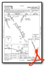
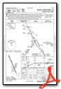
Instrument Approach Procedure (IAP) Charts
Nearby Airports with Instrument Procedures
| ID | Name | Heading / Distance | ||
|---|---|---|---|---|
 |
KBKX | Brookings Regional Airport | 033° | 20.8 |
|
KFSD | Joe Foss Field Airport | 150° | 30.0 |
|
6E5 | Wilder Airport | 320° | 32.3 |
|
KPQN | Pipestone Municipal Airport | 093° | 34.1 |
|
KMHE | Mitchell Municipal Airport | 251° | 43.8 |
|
KLYV | Quentin Aanenson Field Airport | 122° | 44.7 |
|
KRRQ | Rock Rapids Municipal Airport | 130° | 51.9 |
|
KHON | Huron Regional Airport | 294° | 54.1 |
|
KATY | Watertown Regional Airport | 356° | 53.9 |
|
8V3 | Parkston Municipal Airport | 226° | 54.9 |
|
KCNB | Myers Field Airport | 039° | 55.4 |
|
KDVP | Slayton Municipal Airport | 091° | 56.5 |
Airport Images
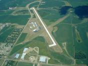
By: jcbecker@pie.mi...


