Login
Register


OTG
Worthington Municipal Airport
Official FAA Data Effective 2026-01-22 0901Z
Chart Supplement

VFR Chart of KOTG
Sectional Charts at SkyVector.com
IFR Chart of KOTG
Enroute Charts at SkyVector.com
Location Information for KOTG
Coordinates: N43°39.30' / W95°34.75'Located 02 miles N of Worthington, Minnesota on 652 acres of land. View all Airports in Minnesota.
Surveyed Elevation is 1574 feet MSL.
Operations Data
|
|
Airport Communications
| AWOS-3PT: | 121.075 Tel. 507-376-9441 |
|---|---|
| UNICOM: | 122.800 |
| CTAF: | 122.800 |
| AWOS-3 at DVP (21.8 NW): | 118.55 507-836-6128 |
| AWOS-3PT at MWM (25.6 NE): | 119.325 507-831-1833 |
| AWOS-3 at MJQ (25.7 E): | 118.1 507-847-5810 |
- APCH/DEP SVC PRVDD BY MINNEAPOLIS ARTCC ON FREQS 132.050/317.4 (SIOUX FALLS RCAG).
Nearby Navigation Aids
|
| ||||||||||||||||||||||||||||||||||||||||||||||||||||||||||||


Runway 11/29
| Dimensions: | 5500 x 100 feet / 1676 x 30 meters | |
|---|---|---|
| Surface: | Asphalt / Grooved in Fair Condition | |
| Weight Limits: | S-44, D-60 | |
| Edge Lighting: | High Intensity | |
| Runway 11 | Runway 29 | |
| Coordinates: | N43°39.46' / W95°35.12' | N43°39.08' / W95°33.99' |
| Elevation: | 1573.5 | 1566.4 |
| Traffic Pattern: | Left | Left |
| Runway Heading: | 115° True | 295° True |
| Markings: | Non-Precision Instrument in good condition. | Precision Instrument in good condition. |
| Glide Slope Indicator | P4L (3.00° Glide Path Angle) | P4L (3.00° Glide Path Angle) |
| Approach Lights: | MALSR 1,400 Foot Medium-intensity Approach Lighting System with runway alignment indicator lights. | |
| REIL: | Yes | |
Runway 18/36
| Dimensions: | 4200 x 75 feet / 1280 x 23 meters | |
|---|---|---|
| Surface: | Asphalt / Grooved in Fair Condition | |
| Weight Limits: | S-44, D-60 | |
| Edge Lighting: | Medium Intensity | |
| Runway 18 | Runway 36 | |
| Coordinates: | N43°39.70' / W95°35.01' | N43°39.00' / W95°35.01' |
| Elevation: | 1571.4 | 1573.9 |
| Traffic Pattern: | Left | Left |
| Runway Heading: | 180° True | 360° True |
| Markings: | Non-Precision Instrument in good condition. | Non-Precision Instrument in good condition. |
| Glide Slope Indicator | P4L (3.00° Glide Path Angle) | P4L (3.00° Glide Path Angle) |
| REIL: | Yes | Yes |
Services Available
| Fuel: | 100LL (blue), Jet-A |
|---|---|
| Transient Storage: | Hangars,Tiedowns |
| Airframe Repair: | MAJOR |
| Engine Repair: | MINOR |
| Bottled Oxygen: | NONE |
| Bulk Oxygen: | NONE |
| Other Services: | CROP DUSTING SERVICES,PILOT INSTRUCTION,AIRCRAFT RENTAL,AIRCRAFT SALES |
Ownership Information
| Ownership: | Publicly owned | |
|---|---|---|
| Owner: | CITY OF WORTHINGTON | |
| 303 NINTH ST., BOX 279 | ||
| WORTHINGTON, MN 56187-2335 | ||
| 507-372-8600 | ||
| Manager: | TODD WIETZEMA | CAMERON JOHNSON - 507-376-9293. |
| 303 NINTH ST., BOX 279 | ||
| WORTHINGTON, MN 56817-0279 | ||
| 507-372-8650 | ||
Other Remarks
- 0LL SELF SVC FUEL WITH CREDIT CARD.
- SELF SVC FUEL AVBL WITH CREDIT CARD. JET A TRUCK AVBL WHEN ATNDD.
- ACTVT MALSR RWY 29; REIL RWY 11, 18 & 36; PAPI RWY 18 & 36; MIRL RWY 18/36 - CTAF. HIRL RWY 11/29 PRESET ON LOW INTST; TO INCR INTST - CTAF. PAPI RWY 11 & 29 OPR CONSLY.
Weather Minimums


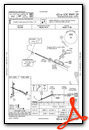
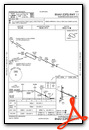
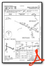
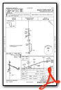
Instrument Approach Procedure (IAP) Charts

Nearby Airports with Instrument Procedures
| ID | Name | Heading / Distance | ||
|---|---|---|---|---|
 |
KISB | Sibley Municipal Airport | 204° | 18.9 |
|
KDVP | Slayton Municipal Airport | 336° | 21.8 |
|
KMWM | Windom Municipal Airport | 052° | 25.6 |
|
KMJQ | Jackson Municipal Airport | 090° | 25.8 |
|
4D8 | Fuller Airport | 136° | 26.6 |
|
KLYV | Quentin Aanenson Field Airport | 265° | 27.9 |
|
KRRQ | Rock Rapids Municipal Airport | 245° | 28.9 |
|
KSHL | Sheldon Regional Airport | 202° | 29.0 |
|
KSPW | Spencer Municipal Airport | 150° | 33.7 |
|
KTKC | Tracy Municipal Airport | 358° | 35.7 |
|
KPQN | Pipestone Municipal Airport | 302° | 37.0 |
|
KEST | Estherville Municipal Airport | 111° | 39.3 |
Airport Images

By: Bandco


