Login
Register


AEL
Albert Lea Municipal Airport
Official FAA Data Effective 2026-01-22 0901Z
Chart Supplement

VFR Chart of KAEL
Sectional Charts at SkyVector.com
IFR Chart of KAEL
Enroute Charts at SkyVector.com
Location Information for KAEL
Coordinates: N43°40.88' / W93°22.09'Located 03 miles N of Albert Lea, Minnesota on 273 acres of land. View all Airports in Minnesota.
Surveyed Elevation is 1261 feet MSL.
Operations Data
|
|
Airport Communications
| AWOS-3PT: | 119.575 Tel. 507-377-1583 |
|---|---|
| ROCHESTER APPROACH: | 119.8 251.125 |
| ROCHESTER DEPARTURE: | 119.8 251.125 |
| UNICOM: | 123.000 |
| CTAF: | 123.000 |
| AWOS-3 at AUM (18.9 E): | 119.025 507-433-6667 |
| AWOS-3 at ACQ (24.7 N): | 118.425 507-835-3657 |
| AWOS-3 at OWA (26.9 N): | 128.325 507-455-0642 |
- APCH/DEP SVC PRVDD BY MINNEAPOLIS ARTCC ON FREQS 132.35/307.3 (ROCHESTER RCAG) WHEN ROCHESTER APCH IS CLSD.
Nearby Navigation Aids
|
| ||||||||||||||||||||||||||||||||||||||||||||||||||||||


Runway 17/35
| Dimensions: | 5000 x 100 feet / 1524 x 30 meters | |
|---|---|---|
| Surface: | Asphalt in Good Condition | |
| Weight Limits: | S-19, D-29 | |
| Edge Lighting: | Medium Intensity | |
| Runway 17 | Runway 35 | |
| Coordinates: | N43°41.26' / W93°22.23' | N43°40.46' / W93°22.00' |
| Elevation: | 1260.0 | 1261.0 |
| Traffic Pattern: | Left | Left |
| Runway Heading: | 168° True | 348° True |
| Markings: | Non-Precision Instrument in good condition. | Non-Precision Instrument in good condition. |
| Glide Slope Indicator | P4L (3.00° Glide Path Angle) | P4L (3.00° Glide Path Angle) |
| Approach Lights: | ODALS Omnidirectional Approach Lighting System | |
| REIL: | Yes | Yes |
| Obstacles: | 7 ft Road 332 ft from runway, 499 ft right of center | |
Runway 05/23
| Dimensions: | 2898 x 75 feet / 883 x 23 meters | |
|---|---|---|
| Surface: | Asphalt in Good Condition | |
| Runway 05 | Runway 23 | |
| Coordinates: | N43°40.74' / W93°22.28' | N43°41.07' / W93°21.81' |
| Elevation: | 1252.8 | 1256.9 |
| Traffic Pattern: | Left | Left |
| Runway Heading: | 47° True | 227° True |
| Markings: | Non-Precision Instrument in good condition. | Non-Precision Instrument in good condition. |
Services Available
| Fuel: | 100LL (blue), Jet-A, Automotive Gasoline |
|---|---|
| Transient Storage: | Hangars,Tiedowns |
| Airframe Repair: | MINOR |
| Engine Repair: | MINOR |
| Bottled Oxygen: | NONE |
| Bulk Oxygen: | NONE |
| Other Services: | PILOT INSTRUCTION,AIRCRAFT RENTAL,AIRCRAFT SALES |
Ownership Information
| Ownership: | Publicly owned | |
|---|---|---|
| Owner: | CITY OF ALBERT LEA | |
| 221 E CLARK STREET | ||
| ALBERT LEA, MN 56007 | ||
| 507-377-4300 | ||
| Manager: | JIM HANSON | |
| 73950 275TH ST. | EMAIL ADDRESS: JIMHANSON@DESKMEDIA.COM (ALL LOWER CASE) | |
| CLARKS GROVE, MN 56016 | ||
| 507-373-0608 | ||
Other Remarks
- TV TWR 9.5 NM SE.
- GLIDERS & HELICOPTERS USE TURF PARALLEL TO RY 17/35 ON EAST SIDE & APPR AREA TO RY 23.
- MULTIPLE TRANSITIONAL OBSTNS RY 05 & RY 35.
- FOR CD CTC ROCHESTER APCH AT 507-424-8111.
- 0LL 100LL & MOGAS FUEL AVBL 24 HR WITH CREDIT CARD.
- ACTVT ODALS RWY 17; REIL RWY 17 & 35; PAPI RWY 17 & 35; MIRL RWY 17/35 - CTAF. MIRL RWY 17/35 PRESET TO LOW SS-SR TO INCR INTST - CTAF.
Weather Minimums


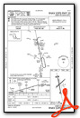
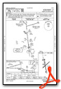
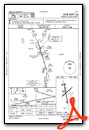
Instrument Approach Procedure (IAP) Charts

Nearby Airports with Instrument Procedures
| ID | Name | Heading / Distance | ||
|---|---|---|---|---|
 |
KAUM | Austin Municipal Airport | 093° | 19.0 |
|
KACQ | Waseca Municipal/Maynard Richard Stensrud Field Airport | 341° | 24.9 |
|
KOWA | Owatonna Degner Regional Airport | 010° | 26.9 |
|
KFXY | Forest City Municipal/Trimble Field Airport | 202° | 29.0 |
|
KTOB | Dodge Center Airport | 048° | 30.8 |
|
KMCW | Mason City Municipal Airport | 177° | 31.4 |
|
KSBU | Blue Earth Municipal Airport | 260° | 32.0 |
|
KFBL | Faribault Municipal-Liz Wall Strohfus Field Airport | 003° | 38.9 |
|
KRST | Rochester International Airport | 069° | 40.1 |
|
KMKT | Mankato Regional Airport | 323° | 40.3 |
|
KFRM | Fairmont Municipal Airport | 267° | 45.7 |
|
KCCY | Northeast Iowa Regional Airport | 137° | 49.3 |
Airport Images
Do you have a recent image of this airport? Upload it here!


Comments
Deceptive
Pulled up for gas priced at $4.50 and a fellow shows up without being requested and helps me with the ladder. I fuel my plane and use the restroom and get my receipt. Got charged almost a buck a gallon higher because I got charged FULL SERVICE PRICE.
I will never do business here again.