Login
Register


GSO
Piedmont Triad International Airport
Official FAA Data Effective 2026-01-22 0901Z
Chart Supplement

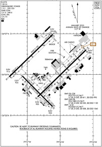
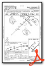
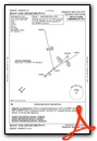
KGSO Airport Diagram
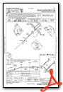
VFR Chart of KGSO
Sectional Charts at SkyVector.com
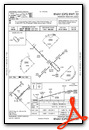
IFR Chart of KGSO
Enroute Charts at SkyVector.com
Location Information for KGSO
Coordinates: N36°6.08' / W79°56.47'Located 07 miles W of Greensboro, North Carolina on 3770 acres of land. View all Airports in North Carolina.
Surveyed Elevation is 925 feet MSL.
Operations Data
|
|
Airport Communications
| D-ATIS: | 128.55 |
|---|---|
| ASOS: | 128.55 Tel. 336-355-1608 |
| GREENSBORO TOWER: | 119.1 290.325 |
| GREENSBORO GROUND: | 121.9 348.6 |
| GREENSBORO APPROACH: | 124.35 ;250-049 126.6 ;050-249 269.225 ;250-049 327.075 ;050-249 |
| GREENSBORO DEPARTURE: | 124.35 ;250-049 126.6 ;050-249 269.225 ;250-049 327.075 ;050-249 |
| IC: | 124.35 ;250-049 126.6 ;050-249 269.225 ;250-049 327.075 ;050-249 |
| CLEARANCE DELIVERY: | 121.75 |
| BLOCC STAR: | 124.35 ;250-049 126.6 ;050-249 269.225 ;250-049 327.075 ;050-249 |
| CLASS C: | 124.35 ;250-049 126.6 ;050-249 269.225 ;250-049 327.075 ;050-249 |
| BROOK STAR: | 124.35 ;250-049 126.6 ;050-249 269.225 ;250-049 327.075 ;050-249 |
| TRAKS STAR: | 124.35 ;250-049 126.6 ;050-249 269.225 ;250-049 327.075 ;050-249 |
| UNICOM: | 122.950 |
| TRIAD DP: | 124.35 ;250-049 126.6 ;050-249 269.225 ;250-049 327.075 ;050-249 |
| HENBY STAR: | 124.35 ;250-049 126.6 ;050-249 269.225 ;250-049 327.075 ;050-249 |
| EMERG: | 121.5 243.0 |
| TRSHA DP: | 124.35 ;250-049 126.6 ;050-249 269.225 ;250-049 327.075 ;050-249 |
| ASOS at INT (13.8 W): | 336-661-3096 |
| ATIS at INT (13.8 W): | 121.3 |
| AWOS-3 at SIF (20.8 N): | 119.775 336-573-3677 |
Nearby Navigation Aids
|
| ||||||||||||||||||||||||||||||||||||||||||||||||||||||||||||


Runway 05R/23L
| Dimensions: | 10001 x 150 feet / 3048 x 46 meters | |
|---|---|---|
| Surface: | Asphalt / Grooved in Good Condition | |
| Weight Limits: | S-120, D-250, ST-550, DT-1120
PCR VALUE: 1080/F/C/W/T
| |
| Edge Lighting: | High Intensity | |
| Runway 05R | Runway 23L | |
| Coordinates: | N36°5.46' / W79°56.68' | N36°6.61' / W79°55.22' |
| Elevation: | 899.5 | 885.8 |
| Traffic Pattern: | Left | Left |
| Runway Heading: | 46° True | 226° True |
| Declared Distances: | TORA:10001 TODA:10001 ASDA:10001 LDA:10001 | TORA:10001 TODA:10001 ASDA:9601 LDA:9601 |
| Markings: | Precision Instrument in good condition. | Precision Instrument in good condition. |
| Glide Slope Indicator | P4R (3.00° Glide Path Angle) | P4L (3.00° Glide Path Angle) |
| RVR Equipment | Touchdown Midfield Rollout | Touchdown Midfield Rollout |
| Approach Lights: | MALSR 1,400 Foot Medium-intensity Approach Lighting System with runway alignment indicator lights. | ALSF2 Standard 2,400 Foot High-intensity Approach Lighting System with sequenced flashers, CATEGORY II or III Configuration. |
| Centerline Lights: | Yes | Yes |
Runway 05L/23R
| Dimensions: | 9000 x 150 feet / 2743 x 46 meters | |
|---|---|---|
| Surface: | Asphalt / Grooved in Fair Condition | |
| Weight Limits: | S-120, D-250, ST-411, DT-995
PCR VALUE: 770/F/C/W/T
| |
| Edge Lighting: | High Intensity | |
| Runway 05L | Runway 23R | |
| Coordinates: | N36°5.96' / W79°57.54' | N36°6.99' / W79°56.23' |
| Elevation: | 916.4 | 855.3 |
| Runway Heading: | 46° True | 226° True |
| Declared Distances: | TORA:9000 TODA:9000 ASDA:9000 LDA:9000 | TORA:9000 TODA:9000 ASDA:9000 LDA:9000 |
| Markings: | Precision Instrument in good condition. | Precision Instrument in good condition. |
| Glide Slope Indicator | P4L (3.00° Glide Path Angle) | P4L (3.00° Glide Path Angle) |
| RVR Equipment | Touchdown Midfield Rollout | Touchdown Midfield Rollout |
| Approach Lights: | ALSF2 Standard 2,400 Foot High-intensity Approach Lighting System with sequenced flashers, CATEGORY II or III Configuration. | MALSR 1,400 Foot Medium-intensity Approach Lighting System with runway alignment indicator lights. |
| Centerline Lights: | Yes | Yes |
Runway 14/32
| Dimensions: | 6380 x 150 feet / 1945 x 46 meters | |
|---|---|---|
| Surface: | Asphalt / Grooved in Fair Condition | |
| Weight Limits: | S-120, D-250, ST-508, DT-1045
PCR VALUE: 850/F/C/W/T
| |
| Edge Lighting: | High Intensity | |
| Runway 14 | Runway 32 | |
| Coordinates: | N36°5.97' / W79°57.15' | N36°5.22' / W79°56.23' |
| Elevation: | 925.4 | 900.0 |
| Traffic Pattern: | Left | Left |
| Runway Heading: | 135° True | 315° True |
| Declared Distances: | TORA:6380 TODA:6380 ASDA:6380 LDA:6380 | TORA:6380 TODA:6380 ASDA:6380 LDA:6380 |
| Markings: | Precision Instrument in good condition. | Precision Instrument in good condition. |
| Glide Slope Indicator | P4L (3.00° Glide Path Angle) | |
| REIL: | Yes | |
Services Available
| Fuel: | 100LL (blue), Jet-A |
|---|---|
| Transient Storage: | Hangars,Tiedowns |
| Airframe Repair: | MAJOR |
| Engine Repair: | MAJOR |
| Bottled Oxygen: | NONE |
| Bulk Oxygen: | HIGH/LOW |
| Other Services: | AIR FREIGHT SERVICES,AVIONICS,CARGO HANDLING SERVICES,CHARTER SERVICE,PILOT INSTRUCTION,AIRCRAFT RENTAL,AIRCRAFT SALES |
Ownership Information
| Ownership: | Publicly owned | |
|---|---|---|
| Owner: | PIEDMONT TRIAD ARPT AUTH. | |
| 1000A TED JOHNSON PKWY | ||
| GREENSBORO, NC 27409 | ||
| 336-665-5600 | ||
| Manager: | KEVIN BAKER | |
| 1000A TED JOHNSON PKWY | ||
| GREENSBORO, NC 27409 | ||
| 336-665-5600 | ||
Other Remarks
- ACFT WITH WINGSPAN GREATER THAN 171 FT ARE PROHIBITED FROM USING TWY E.
- DUE TO NOISE SENSITIVE AREAS, ACFT PERFORMING PRACTICE APPROACHES SHALL USE RWY 05R-23L.
- TWY E PORTIONS BETWEEN TWY J AND TWY H NOT VISIBLE FROM ATCT. TWY K NORTHEAST OF TWY K6 CLSD EXCEPT FOR CARGO ACFT.
- FOR CD CTC GREENSBORO APCH AT 743-222-6129 IF UNABL ON VHF 121.75.
Weather Minimums

Standard Terminal Arrival (STAR) Charts
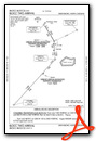
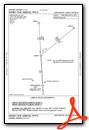
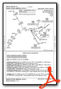
Instrument Approach Procedure (IAP) Charts
- ILS OR LOC RWY 05L
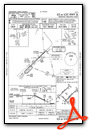
- ILS OR LOC RWY 05R

- ILS OR LOC RWY 23L
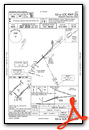
- ILS OR LOC RWY 23R

- ILS Y OR LOC Y RWY 32
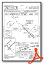
- ILS Z OR LOC Z RWY 32

- ILS RWY 23L (CAT II)

- ILS RWY 05L (CAT II - III)
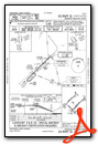
- ILS RWY 05R (SA CAT II)
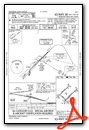
- RNAV (GPS) RWY 05L
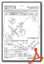
- RNAV (GPS) RWY 05R
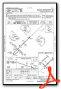
- RNAV (GPS) RWY 14

- RNAV (GPS) RWY 23L
- RNAV (GPS) RWY 23R
- RNAV (GPS) RWY 32
- VOR/DME RWY 23L

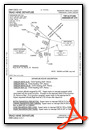
Departure Procedure (DP) Charts

Nearby Airports with Instrument Procedures
| ID | Name | Heading / Distance | ||
|---|---|---|---|---|
 |
KINT | Smith Reynolds Airport | 278° | 13.8 |
|
N63 | Meadow Brook Field Airport | 319° | 15.7 |
|
KSIF | Rockingham County Nc Shiloh Airport | 012° | 20.6 |
|
KBUY | Burlington/Alamance Regional Airport | 097° | 23.0 |
|
KEXX | Davidson County Exec Airport | 222° | 26.1 |
|
KHBI | Asheboro Regional Airport | 175° | 26.9 |
|
8A7 | Twin Lakes Airport | 246° | 27.5 |
|
KSCR | Siler City Municipal Airport | 138° | 31.9 |
|
KMTV | Blue Ridge Airport | 353° | 31.9 |
|
KMWK | Mount Airy/Surry County Airport | 306° | 36.7 |
|
KRUQ | Mid-Carolina Regional Airport | 226° | 39.3 |
|
KDAN | Danville Regional Airport | 045° | 40.7 |
Fuel Providers


We proudly offer fuel from:

US Dollar per US Gallon
Price Guaranteed by FBO
Airport Images

By: laser


