Login
Register


RUQ
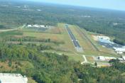
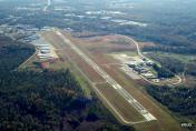
Mid-Carolina Regional Airport
Official FAA Data Effective 2026-01-22 0901Z
Chart Supplement

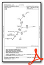
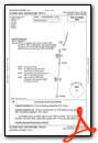
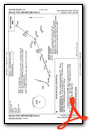
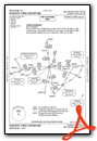
KRUQ Airport Diagram

VFR Chart of KRUQ
Sectional Charts at SkyVector.com
IFR Chart of KRUQ
Enroute Charts at SkyVector.com
Location Information for KRUQ
Coordinates: N35°38.75' / W80°31.22'Located 03 miles SW of Salisbury, North Carolina on 400 acres of land. View all Airports in North Carolina.
Surveyed Elevation is 772 feet MSL.
Operations Data
|
|
Airport Communications
| AWOS-3P: | 118.175 Tel. 704-637-6197 |
|---|---|
| CHARLOTTE APPROACH: | 128.325 307.8 |
| CHARLOTTE DEPARTURE: | 128.325 307.8 |
| CLEARANCE DELIVERY: | 127.35 |
| ICONS DP: | 128.325 307.8 |
| WEAZL DP: | 128.325 307.8 |
| ESTRR DP: | 128.325 307.8 |
| KNIGHTS DP: | 128.325 307.8 |
| KERMIT DP: | 128.325 307.8 |
| LILLS DP: | 128.325 307.8 |
| JOOLS STAR: | 135.6 377.15 |
| BEAVY DP: | 128.325 307.8 |
| KRITR DP: | 128.325 307.8 |
| JOJJO DP: | 128.325 307.8 |
| BOBZY DP: | 128.325 307.8 |
| KABEE STAR: | 126.15 282.325 |
| UNICOM: | 122.725 |
| KWEEN DP: | 128.325 307.8 |
| KILNS DP: | 128.325 307.8 |
| NASCR STAR: | 128.325 |
| CTAF: | 122.725 |
| BARMY DP: | 128.325 307.8 |
| AWOS-3 at EXX (13.3 NE): | 119.825 336-956-2967 |
| AWOS-3 at JQF (17.9 SW): | 133.675 704-785-2145 |
| ATIS at JQF (18.0 SW): | 133.675 |
Nearby Navigation Aids
|
| ||||||||||||||||||||||||||||||||||||||||||||||||||||||||||||


Runway 02/20
| Dimensions: | 5501 x 100 feet / 1677 x 30 meters | |
|---|---|---|
| Surface: | Asphalt in Good Condition | |
| Weight Limits: | S-45, D-55 | |
| Edge Lighting: | Medium Intensity | |
| Runway 02 | Runway 20 | |
| Coordinates: | N35°38.32' / W80°31.37' | N35°39.19' / W80°31.06' |
| Elevation: | 769.1 | 765.6 |
| Runway Heading: | 16° True | 196° True |
| Displaced Threshold: | 126 Feet | |
| Markings: | Non-Precision Instrument in good condition. | Precision Instrument in good condition. |
| Glide Slope Indicator | P2L (3.00° Glide Path Angle) | P2L (3.00° Glide Path Angle) |
| Approach Lights: | MALSR 1,400 Foot Medium-intensity Approach Lighting System with runway alignment indicator lights. | |
| REIL: | Yes | Yes |
| Obstacles: | 35 ft Trees 814 ft from runway, 356 ft left of center APCH RATIO 22:1 AT DSPLCD DUE TO 41 FT TREES 1123 FT FM THR OFFSET 418 LEFT OF CNTRLN. |
23 ft Trees 231 ft from runway, 297 ft left of center 15 FT TREES 0-200 FT FM THR OFFSET 325 FT LEFT OF CNTRLN. |
Services Available
| Fuel: | 100LL (blue), Jet A-1+ |
|---|---|
| Transient Storage: | Hangars,Tiedowns |
| Airframe Repair: | MAJOR |
| Engine Repair: | MAJOR |
| Bottled Oxygen: | LOW |
| Bulk Oxygen: | NONE |
| Other Services: | AIR FREIGHT SERVICES,AVIONICS,CHARTER SERVICE,PILOT INSTRUCTION,PARACHUTE JUMP ACTIVITY,AIRCRAFT RENTAL |
Ownership Information
| Ownership: | Publicly owned | |
|---|---|---|
| Owner: | ROWAN COUNTY | |
| 130 W. INNES ST | ||
| SALISBURY, NC 28144 | ||
| 704-216-8100 | ||
| Manager: | VALERIE STEELE | |
| 3670 AIRPORT LOOP | ||
| SALISBURY, NC 28147-8921 | ||
| 704-216-7753 | ||
Other Remarks
- MAIN TRML APRON GRASS AREA ADJ TO FUEL PUMPS CLSD TO HELS.
- BE ALERT FOR MIL ROTOR WING TFC. RNG RAMP LCTD W OF RWY. FRQ NGT OPS.
- CTC KILLDEVIL OPS 10 MIN PRIOR TO LDG. RNG OPS FREQ - 40.700, 126.100, 293.000.
- FOR CD CTC CHARLOTTE APCH AT 704-359-0241.
- ADDNL OBSTNS FOR RWY 02; 20 FT BLDG 1100 FT FM THR 100 FT R OF CNTRLN.
- 24 HR SVC BY REQ. FOR AFT HRS SVC CALL 980-892-2840.
- TRANSIT MIL FUEL.
- RMK: ARNG; LTD PRK RAMP CLSD TO ALL TFC EXC MIL ACFT WITH PPR. OPR 1200-2030Z++ MON-FRI EXC HOL.
- SKY DIVING OPS OVR ARPT; DO NOT OVERFLY ARPT DRG SKY DIVING OPS.
- 0LL 24 SELF SERVICE AVBL FOR 100LL WITH CREDIT CARD.
- + MIL FUEL A+ CTC KILLDEVIL OPS 24 HR PPR, C 984-661-6506/6507/6557.
- ACTVT MALSR RWY 20; REIL RWY 02 & 20; PAPI RWY 02 & 20; MIRL RWY 02/20 - CTAF.
Weather Minimums

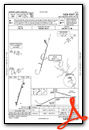
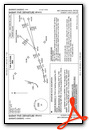
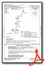
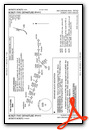
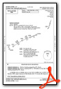
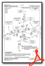
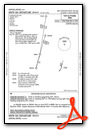
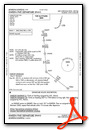
Standard Terminal Arrival (STAR) Charts

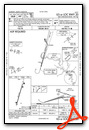
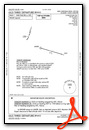
Instrument Approach Procedure (IAP) Charts

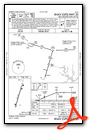
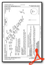
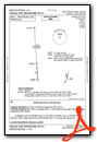
Departure Procedure (DP) Charts

Nearby Airports with Instrument Procedures
| ID | Name | Heading / Distance | ||
|---|---|---|---|---|
 |
KEXX | Davidson County Exec Airport | 052° | 13.3 |
|
8A7 | Twin Lakes Airport | 010° | 16.4 |
|
KJQF | Concord-Padgett Regional Airport | 210° | 18.0 |
|
14A | Lake Norman Airpark Airport | 264° | 18.6 |
|
KSVH | Statesville Regional Airport | 288° | 22.4 |
|
KVUJ | Stanly County Airport | 127° | 22.7 |
|
KHBI | Asheboro Regional Airport | 088° | 30.6 |
|
KINT | Smith Reynolds Airport | 026° | 32.6 |
|
KIPJ | Lincoln County Regional Airport | 252° | 32.9 |
|
KCLT | Charlotte/Douglas International Airport | 219° | 33.4 |
|
KEQY | Charlotte/Monroe Exec Airport | 187° | 38.0 |
|
43A | Montgomery County Airport | 113° | 39.0 |