Login
Register


BBG
Branson Airport
Official FAA Data Effective 2026-01-22 0901Z
Chart Supplement

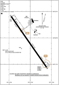
KBBG Airport Diagram
VFR Chart of KBBG
Sectional Charts at SkyVector.com
IFR Chart of KBBG
Enroute Charts at SkyVector.com
Location Information for KBBG
Coordinates: N36°31.92' / W93°12.03'Located 08 miles SSE of Branson, Missouri on 922 acres of land. View all Airports in Missouri.
Estimated Elevation is 1302 feet MSL.
Operations Data
|
|
Airport Communications
| ATIS: | 124.625 |
|---|---|
| AWOS-2: | 124.625 Tel. 417-334-0218 |
| BRANSON TOWER: | 128.15 |
| BRANSON GROUND: | 118.4 |
| SPRINGFIELD APPROACH: | 126.35 |
| SPRINGFIELD DEPARTURE: | 126.35 |
| CLEARANCE DELIVERY: | 118.4 126.35 |
| UNICOM: | 122.950 |
| CTAF: | 128.150 |
| AWOS-3PT at FWB (13.9 NW): | 119.725 417-272-3922 |
| ASOS at HRO (16.4 S): | 121.125 870-365-8550 |
| AWOS-3PT at FLP (33.0 SE): | 132.075 870-453-2380 |
- CLNC DEL PRVDD BY SPRINGFIELD APP CON ON FREQ 126.35 WHEN ATCT CLSD.
Nearby Navigation Aids
|
| ||||||||||||||||||||||||||||||||||||||||||||||||


Runway 14/32
| Dimensions: | 7140 x 150 feet / 2176 x 46 meters | |
|---|---|---|
| Surface: | Concrete / Grooved in Good Condition | |
| Weight Limits: | S-75, D-200, ST-350, DT-700
PCR VALUE: 510/R/C/W/T
| |
| Edge Lighting: | High Intensity | |
| Runway 14 | Runway 32 | |
| Coordinates: | N36°32.41' / W93°12.45' | N36°31.44' / W93°11.61' |
| Elevation: | 1254.9 | 1301.8 |
| Traffic Pattern: | Right | |
| Runway Heading: | 145° True | 325° True |
| Declared Distances: | TORA:7140 TODA:7140 ASDA:7140 LDA:7140 | TORA:7140 TODA:7140 ASDA:7140 LDA:7140 |
| Markings: | Non-Precision Instrument in good condition. | Precision Instrument in good condition. |
| Glide Slope Indicator | P4L (3.00° Glide Path Angle) | P4L (3.00° Glide Path Angle) |
| Approach Lights: | MALSF 1,400 Foot Medium-intensity Approach Lighting System with sequenced flashers. | |
| REIL: | Yes | |
Services Available
| Fuel: | 100LL (blue), Jet-A, Jet A+ |
|---|---|
| Transient Storage: | Hangars,Tiedowns |
| Airframe Repair: | NOT AVAILABLE |
| Engine Repair: | NOT AVAILABLE |
| Bottled Oxygen: | NOT AVAILABLE |
| Bulk Oxygen: | NOT AVAILABLE |
Ownership Information
| Ownership: | Publicly owned | |
|---|---|---|
| Owner: | TANEY COUNTY | LEASED TO BRANSON RGNL ARPT TRNSPN DVLPTMT DIST. |
| 4000 BRANSON AIRPORT BLVD. | ||
| HOLLISTER, MO 65672 | ||
| 417-334-7813 | ||
| Manager: | BRANSON AIRPORT, LLC- STANLEY FIELD | |
| 4000 BRANSON AIRPORT BLVD. | ||
| HOLLISTER, MO 65672 | ||
| 417-334-7813 | ||
Other Remarks
- HILLS & UNEVEN TRRN INVOF; TRRN AVOIDANCE MAY ACTVT ON FNL.
- BIRDS INVOF ARPT.
- CALM WIND RWY.
- 0LL 100LL CREDIT CARD SELF SVC AVBL H24 AT GA APRON.
- WHEN ATCT CLSD: ACTVT MALSF RWY 32; REIL RWY 14; PAPI RWY 14 & 32; HIRL RWY 14/32 - CTAF.
Weather Minimums


Instrument Approach Procedure (IAP) Charts

Nearby Airports with Instrument Procedures
| ID | Name | Heading / Distance | ||
|---|---|---|---|---|
 |
KPLK | M Graham Clark Downtown Airport | 346° | 5.8 |
|
KFWB | Branson West Municipal/Emerson Field Airport | 315° | 13.9 |
|
KHRO | Boone County Airport | 172° | 16.4 |
|
4M1 | Carroll County Airport | 246° | 22.4 |
|
KFLP | Marion County Regional Airport | 115° | 32.9 |
|
2H2 | Jerry Sumners Sr Aurora Municipal Airport | 317° | 35.1 |
|
94K | Cassville Municipal Airport | 286° | 35.2 |
|
KAOV | Ava Bill Martin Memorial Airport | 043° | 36.3 |
|
KBPK | Baxter County Airport | 105° | 36.7 |
|
H34 | Huntsville Municipal Airport | 224° | 38.2 |
|
3DW | Downtown Airport | 356° | 41.4 |
|
KSGF | Springfield-Branson Ntl Airport | 348° | 43.7 |
Airport Images
Do you have a recent image of this airport? Upload it here!


