Login
Register


HBZ
Heber Springs Municipal Airport
Official FAA Data Effective 2026-02-19 0901Z
Chart Supplement

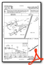
VFR Chart of KHBZ
Sectional Charts at SkyVector.com
IFR Chart of KHBZ
Enroute Charts at SkyVector.com
Location Information for KHBZ
Coordinates: N35°30.70' / W92°0.78'Located 02 miles NE of Heber Springs, Arkansas on 109 acres of land. View all Airports in Arkansas.
Surveyed Elevation is 632 feet MSL.
Operations Data
|
|
Airport Communications
| CTAF: | 122.700 |
|---|---|
| UNICOM: | 122.700 |
| AWOS-3 at CCA (21.7 W): | 118.725 501-745-5000 |
| AWOS-3PT at BVX (22.0 NE): | 126.375 870-251-1369 |
| AWOS-3PT at SRC (22.6 SE): | 128.325 501-268-4280 |
- APCH/DEP SVC PRVDD BY MEMPHIS ARTCC ON FREQS 126.85/281.55 (BRINKLEY RCAG).
Nearby Navigation Aids
|
| ||||||||||||||||||||||||||||||||||||||||||||||||||||||||||||


Runway 06/24
| Dimensions: | 4002 x 75 feet / 1220 x 23 meters | |
|---|---|---|
| Surface: | Asphalt in Good Condition | |
| Weight Limits: | S-12 | |
| Edge Lighting: | Medium Intensity | |
| Runway 06 | Runway 24 | |
| Coordinates: | N35°30.53' / W92°1.13' | N35°30.87' / W92°0.43' |
| Elevation: | 620.4 | 631.9 |
| Traffic Pattern: | Left | Left |
| Runway Heading: | 60° True | 240° True |
| Markings: | Non-Precision Instrument in good condition. | Non-Precision Instrument in good condition. |
| Glide Slope Indicator | P2L (3.00° Glide Path Angle) | P2L (3.00° Glide Path Angle) |
| REIL: | Yes | Yes |
| Obstacles: | 34 ft Trees 705 ft from runway, 180 ft right of center | |
Services Available
| Fuel: | 100LL (blue), Jet-A |
|---|---|
| Transient Storage: | Tiedowns |
| Airframe Repair: | MAJOR |
| Engine Repair: | MAJOR |
| Bottled Oxygen: | LOW |
| Bulk Oxygen: | NONE |
| Other Services: | PILOT INSTRUCTION,AIRCRAFT RENTAL |
Ownership Information
| Ownership: | Publicly owned | |
|---|---|---|
| Owner: | CITY OF HEBER SPRINGS | |
| 1001 WEST MAIN | ||
| HEBER SPRINGS, AR 72543 | ||
| 501-362-3635 | ||
| Manager: | CHARLES EVANS | |
| 2111 AIRPORT RD | ||
| HEBER SPRINGS, AR 72543 | ||
| 501-362-3294 | ||
Other Remarks
- THIS AIRPORT HAS BEEN SURVEYED BY THE NATIONAL GEODETIC SURVEY.
- RWY 06/24 NO LINE OF SIGHT BTN RY ENDS.
- FOR CD CTC MEMPHIS ARTCC AT 901-368-8453/8449.
- DEER ON & INVOF ARPT.
- 0LL SELF-SERVICE FUEL AVBL 24 HRS WITH CREDIT CARD (100LL & JET A)
- DUSK-DAWN. ACTVT REIL RWY 06/24 AND MIRL RWY 06/24 - CTAF.
Weather Minimums

Instrument Approach Procedure (IAP) Charts

Nearby Airports with Instrument Procedures
| ID | Name | Heading / Distance | ||
|---|---|---|---|---|
 |
2A2 | Holley Mountain Airpark Airport | 293° | 20.9 |
|
7M2 | Mountain View Wilcox Memorial Field Airport | 349° | 21.5 |
|
KBVX | Batesville Regional Airport | 054° | 22.0 |
|
KCCA | Clinton Municipal Airport | 283° | 22.1 |
|
KSRC | Searcy Regional Airport | 143° | 22.5 |
|
42A | Melbourne Municipal/John E Miller Field Airport | 014° | 34.7 |
|
KLRF | Little Rock AFB Airport | 190° | 36.2 |
|
4A5 | Searcy County Airport | 306° | 39.1 |
|
M60 | Woodruff County Airport | 111° | 39.2 |
|
KCXW | Conway Regional Airport | 222° | 39.7 |
|
KBDQ | Morrilton Municipal Airport | 237° | 41.1 |
|
M19 | Newport Regional Airport | 079° | 41.6 |
Airport Images

By: Big Orange Bird


