Login
Register


CXW
Conway Regional Airport
Official FAA Data Effective 2026-01-22 0901Z
Chart Supplement

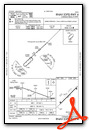
VFR Chart of KCXW
Sectional Charts at SkyVector.com
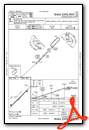
IFR Chart of KCXW
Enroute Charts at SkyVector.com
Location Information for KCXW
Coordinates: N35°1.19' / W92°33.31'Located 07 miles SW of Conway, Arkansas on 432 acres of land. View all Airports in Arkansas.
Surveyed Elevation is 276 feet MSL.
Operations Data
|
|
Airport Communications
| AWOS-2: | 118.775 Tel. 501-358-6209 |
|---|---|
| LITTLE ROCK APPROACH: | 119.5 ;240-039 135.4 ;040-239 306.2 ;240-039 353.6 ;040-239 |
| LITTLE ROCK DEPARTURE: | 119.5 306.2 |
| CLEARANCE DELIVERY: | 121.2 |
| UNICOM: | 123.050 |
| CTAF: | 123.050 |
| AWOS-3PT at ORK (18.5 SE): | 123.775 501-906-6529 |
| ATIS at LRF (21.1 E): | 251.1 |
| ASOS at LIT (23.6 SE): | 501-376-0247 |
Nearby Navigation Aids
|
| ||||||||||||||||||||||||||||||||||||||||||||||||


Runway 04/22
| Dimensions: | 5500 x 100 feet / 1676 x 30 meters | |
|---|---|---|
| Surface: | Concrete / Grooved in Good Condition | |
| Weight Limits: | S-30, D-60, ST-120 | |
| Edge Lighting: | Medium Intensity | |
| Runway 04 | Runway 22 | |
| Coordinates: | N35°0.87' / W92°33.69' | N35°1.51' / W92°32.92' |
| Elevation: | 274.8 | 276.0 |
| Markings: | Non-Precision Instrument in good condition. | Non-Precision Instrument in good condition. |
| Glide Slope Indicator | P2L (3.00° Glide Path Angle) | P2L (3.00° Glide Path Angle) |
| REIL: | Yes | Yes |
Services Available
| Fuel: | 100LL (blue), Jet-A |
|---|---|
| Transient Storage: | Hangars,Tiedowns |
| Airframe Repair: | MAJOR |
| Engine Repair: | MAJOR |
| Bottled Oxygen: | NOT AVAILABLE |
| Bulk Oxygen: | NOT AVAILABLE |
| Other Services: | PILOT INSTRUCTION,AIRCRAFT RENTAL |
Ownership Information
| Ownership: | Publicly owned | |
|---|---|---|
| Owner: | CITY OF CONWAY | |
| 1111 MAIN STREET | ||
| CONWAY, AR 72032 | ||
| 501-450-6110 | ||
| Manager: | JACOB BRILEY | |
| 3250 SAND GAP ROAD | ||
| CONWAY, AR 72034 | ||
| 501-358-6200 | ||
Other Remarks
- FOR CD WHEN UNA VIA FREQ CTC LITTLE ROCK APCH 501-379-2908 OR LITTLE ROCK ATCT 501-379-2911
- 0LL FUEL AVBL 24 HRS SELF SVC WITH CREDIT CARD (100LL).
- ACTVT REIL, PAPI AND MIRL RWYS 4 AND 22 - CTAF.
Weather Minimums

Instrument Approach Procedure (IAP) Charts
Nearby Airports with Instrument Procedures
| ID | Name | Heading / Distance | ||
|---|---|---|---|---|
 |
KBDQ | Morrilton Municipal Airport | 311° | 10.5 |
|
KORK | North Little Rock Municipal Airport | 126° | 18.6 |
|
KMPJ | Petit Jean Park Airport | 292° | 18.8 |
|
KLRF | Little Rock AFB Airport | 106° | 21.1 |
|
KLIT | Bill and Hillary Clinton Ntl/Adams Field Airport | 136° | 23.8 |
|
KSUZ | Saline County Regional Airport | 171° | 26.0 |
|
KRUE | Russellville Regional Airport | 298° | 30.1 |
|
KCCA | Clinton Municipal Airport | 008° | 35.0 |
|
2A2 | Holley Mountain Airpark Airport | 011° | 38.5 |
|
KHBZ | Heber Springs Municipal Airport | 041° | 39.7 |
|
KSRC | Searcy Regional Airport | 073° | 41.8 |
|
KHOT | Memorial Field Airport | 219° | 42.1 |
Fuel Providers

Airport Images
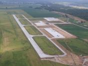
By: ConwayRA

By: ConwayRA


