Login
Register


HHF
Hemphill County Airport
Official FAA Data Effective 2026-02-19 0901Z
Chart Supplement

VFR Chart of KHHF
Sectional Charts at SkyVector.com
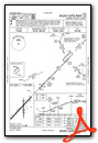
IFR Chart of KHHF
Enroute Charts at SkyVector.com
Location Information for KHHF
Coordinates: N35°53.71' / W100°24.23'Located 02 miles SW of Canadian, Texas on 168 acres of land. View all Airports in Texas.
Surveyed Elevation is 2396 feet MSL.
Operations Data
|
|
Airport Communications
| AWOS-3PT: | 119.025 Tel. 806-225-8080 |
|---|---|
| CTAF: | 122.900 |
| AWOS-3PT at BPC (30.5 W): | 118.1 806-665-5504 |
| AWOS-3 at PPA (33.5 SW): | 118.725 806-669-1333 |
| AWOS-3 at PYX (35.2 NW): | 118.175 806-435-9963 |
- APCH/DEP CTL SVC PRVDD BY ALBUQUERQUE ARTCC ON (ZAB) FREQS 127.85/285.475 (AMARILLO RCAG).
- AIRCRAFT EXECUTING MISSED APCH ON RNAV (GPS) RY 04 CTC KANSAS CITY ARTCC (ZKC) ON 126.95/379.2 (GAGE RCAG).
Nearby Navigation Aids
|
| ||||||||||||||||||||||||||||||||||||||||||||||||||||||||||||


Runway 04/22
| Dimensions: | 5004 x 75 feet / 1525 x 23 meters | |
|---|---|---|
| Surface: | Asphalt in Excellent Condition | |
| Weight Limits: | S-30 | |
| Edge Lighting: | Medium Intensity | |
| Runway 04 | Runway 22 | |
| Coordinates: | N35°53.41' / W100°24.62' | N35°54.00' / W100°23.91' |
| Elevation: | 2387.4 | 2375.6 |
| Traffic Pattern: | Left | Right |
| Runway Heading: | 44° True | 224° True |
| Markings: | Non-Precision Instrument in good condition. | Non-Precision Instrument in good condition. |
| Glide Slope Indicator | P2L (3.00° Glide Path Angle) | P2L (3.00° Glide Path Angle) |
| REIL: | Yes | Yes |
| Obstacles: | 8 ft Fence 390 ft from runway | 46 ft Trees 1417 ft from runway |
Runway 18/36
| Dimensions: | 3001 x 60 feet / 915 x 18 meters | |
|---|---|---|
| Surface: | Asphalt in Excellent Condition | |
| Weight Limits: | S-12 | |
| Edge Lighting: | Medium Intensity | |
| Runway 18 | Runway 36 | |
| Coordinates: | N35°53.96' / W100°24.15' | N35°53.47' / W100°24.21' |
| Elevation: | 2367.6 | 2396.4 |
| Traffic Pattern: | Right | Left |
| Runway Heading: | 185° True | 5° True |
| Displaced Threshold: | 100 Feet | |
| Markings: | Basic in good condition. | Basic in good condition. |
| Obstacles: | 10 ft Road 210 ft from runway, 126 ft right of center | 6 ft Fence 212 ft from runway |
Services Available
| Fuel: | 100LL (blue), Jet-A, A++10 |
|---|---|
| Transient Storage: | Hangars,Tiedowns |
| Airframe Repair: | NOT AVAILABLE |
| Engine Repair: | NOT AVAILABLE |
| Bottled Oxygen: | NONE |
| Bulk Oxygen: | NONE |
Ownership Information
| Ownership: | Publicly owned | |
|---|---|---|
| Owner: | HEMPHILL COUNTY | |
| 400 MAIN STREET, SUITE 200 | ||
| CANADIAN, TX 79014 | ||
| 806-323-6521 | ||
| Manager: | BILL KENDALL | |
| 255 AIRPORT ROAD - PO BOX 96 | ||
| CANADIAN, TX 79014 | ||
| 806-679-4774 | ||
Other Remarks
- 15 FT DITCH N OF RWY 04 THR EXTDG 1000 FT ALG LEFT SIDE OF RWY.
- FOR CD CTC ALBUQUERQUE ARTCC AT 505-856-4861.
- DUSK-DAWN. MIRL RWY 04/22 AND RWY 18/36 PRESET LOW INTST; TO INCR INTST ACTVT - CTAF.
Weather Minimums


Instrument Approach Procedure (IAP) Charts

Nearby Airports with Instrument Procedures
| ID | Name | Heading / Distance | ||
|---|---|---|---|---|
 |
1X1 | Higgins/Lipscomb County Airport | 055° | 22.3 |
|
T59 | Wheeler Municipal Airport | 159° | 28.4 |
|
KPPA | Perry Lefors Field Airport | 239° | 33.5 |
|
KPYX | Perryton Ochiltree County Airport | 331° | 35.3 |
|
E42 | Major Samuel B Cornelius Field Airport | 297° | 43.1 |
|
KBGD | Hutchinson County Airport | 256° | 49.7 |
|
KWWR | West Woodward Airport | 052° | 53.8 |
|
E19 | Gruver Municipal Airport | 292° | 54.0 |
|
KELK | Elk City Regional Business Airport | 119° | 56.7 |
|
T45 | Panhandle-Carson County Airport | 236° | 56.8 |
|
KCSM | Clinton/Sherman Airport | 119° | 67.6 |
|
KMDF | Mooreland Municipal Airport | 058° | 68.6 |
Airport Images
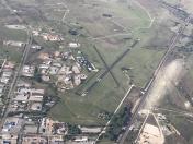
By: Big Orange Bird


