Login
Register


HLC
Hill City Municipal Airport
Official FAA Data Effective 2025-11-27 0901Z
Chart Supplement

VFR Chart of KHLC
Sectional Charts at SkyVector.com
IFR Chart of KHLC
Enroute Charts at SkyVector.com
Location Information for KHLC
Coordinates: N39°22.81' / W99°49.89'Located 01 miles NE of Hill City, Kansas on 183 acres of land. View all Airports in Kansas.
Surveyed Elevation is 2238 feet MSL.
Operations Data
|
|
Airport Communications
| ASOS: | 118.425 Tel. 785-421-3471 |
|---|---|
| CTAF: | 122.900 |
| AWOS-3PT at RCP (24.5 E): | 120.075 785-425-7042 |
| AWOS-3PT at NRN (28.4 N): | 118.275 785-871-4009 |
| AWOS-3PT at PHG (31.9 NE): | 119.125 785-543-8960 |
- APCH/DEP CTL SVC PRVDD BY DENVER ARTCC (ZDV) ON FREQS 132.7/226.675 (HILL CITY RCAG).
Nearby Navigation Aids
|
| ||||||||||||||||||||||||||||||||||||||||||||||||


Runway 18/36
| Dimensions: | 5001 x 75 feet / 1524 x 23 meters | |
|---|---|---|
| Surface: | Concrete in Excellent Condition | |
| Weight Limits: | 8 /R/C/X/U, S-12, D-16 | |
| Edge Lighting: | High Intensity | |
| Runway 18 | Runway 36 | |
| Coordinates: | N39°23.22' / W99°49.88' | N39°22.40' / W99°49.90' |
| Elevation: | 2238.4 | 2187.9 |
| Runway Heading: | 181° True | 1° True |
| Markings: | Non-Precision Instrument in good condition. | Basic in good condition. |
| Glide Slope Indicator | P4L (3.00° Glide Path Angle) | P4L (3.00° Glide Path Angle) |
| REIL: | Yes | Yes |
| Obstacles: | 4 FT BERM, 0-199 DSTC, 8- FT L. |
11 ft Road 495 ft from runway |
Services Available
| Fuel: | 100LL (blue), Jet A+ |
|---|---|
| Transient Storage: | Hangars,Tiedowns |
| Airframe Repair: | NOT AVAILABLE |
| Engine Repair: | NOT AVAILABLE |
| Bottled Oxygen: | NONE |
| Bulk Oxygen: | NONE |
| Other Services: | CROP DUSTING SERVICES |
Ownership Information
| Ownership: | Publicly owned | |
|---|---|---|
| Owner: | CITY OF HILL CITY | |
| 205 N. POMEROY ST. | ||
| HILL CITY, KS 67642 | ||
| 785-421-3438 | ||
| Manager: | CONNOR LARSON | ASST POWER PLANT MGR/AMGR. |
| 205 N. POMEROY ST. | ||
| HILL CITY, KS 67642 | ||
| 785-769-3400 | ||
Other Remarks
- AGRICULTURAL ACFT OPERG VCNTY ARPT DALGT HRS.
- FOR CD IF UNA TO CTC ON FSS FREQ, CTC DENVER ARTCC AT 303-651-4257.
- 0LL SELF SVC FUEL.
- ACTVT REIL RWY 18 & 36; PAPI RWY 18 & 36; HIRL RWY 18/36 - CTAF.
Weather Minimums


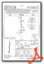
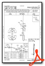
Instrument Approach Procedure (IAP) Charts
Nearby Airports with Instrument Procedures
| ID | Name | Heading / Distance | ||
|---|---|---|---|---|
 |
0H1 | Trego Wakeeney Airport | 187° | 22.6 |
|
KRCP | Rooks County Regional Airport | 094° | 24.6 |
|
1QK | Gove County Airport | 222° | 27.8 |
|
KNRN | Norton Municipal Airport | 354° | 28.3 |
|
KPHG | Phillipsburg Municipal Airport | 048° | 32.0 |
|
KHYS | Hays Regional Airport | 140° | 41.5 |
|
KOIN | Oberlin Municipal Airport | 309° | 42.7 |
|
KOEL | Oakley Municipal Airport | 251° | 48.7 |
|
4D9 | Alma Municipal Airport | 026° | 49.3 |
|
K82 | Smith Center Municipal Airport | 064° | 53.3 |
|
48K | Ness City Municipal Airport | 183° | 54.5 |
|
KCBK | Shalz Field Airport | 273° | 56.6 |
Airport Images
Do you have a recent image of this airport? Upload it here!


