Login
Register


OIN
Oberlin Municipal Airport
Official FAA Data Effective 2026-01-22 0901Z
Chart Supplement

VFR Chart of KOIN
Sectional Charts at SkyVector.com
IFR Chart of KOIN
Enroute Charts at SkyVector.com
Location Information for KOIN
Coordinates: N39°50.06' / W100°32.39'Located 01 miles NW of Oberlin, Kansas on 164 acres of land. View all Airports in Kansas.
Surveyed Elevation is 2706 feet MSL.
Operations Data
|
|
Airport Communications
| AWOS-3PT: | 119.225 Tel. 785-470-4236 |
|---|---|
| UNICOM: | 122.800 |
| CTAF: | 122.800 |
| ASOS at MCK (22.3 N): | 119.025 308-345-1193 |
| AWOS-3 at ADT (23.3 W): | 118.675 785-626-3572 |
| AWOS-3PT at NRN (29.8 E): | 118.275 785-871-4009 |
- APCH/DEP CTL SVC PRVDD BY DENVER ARTCC (ZDV) ON FREQS 132.7/226.675 (GOODLAND RCAG).
Nearby Navigation Aids
|
| ||||||||||||||||||||||||||||||||||||||||||||||||


Runway 17/35
| Dimensions: | 4301 x 60 feet / 1311 x 18 meters | |
|---|---|---|
| Surface: | Asphalt in Good Condition | |
| Weight Limits: | S-12 | |
| Edge Lighting: | Medium Intensity | |
| Runway 17 | Runway 35 | |
| Coordinates: | N39°50.46' / W100°32.41' | N39°49.75' / W100°32.41' |
| Elevation: | 2706.8 | 2667.2 |
| Traffic Pattern: | Left | Left |
| Runway Heading: | 180° True | 0 |
| Displaced Threshold: | 800 Feet | |
| Declared Distances: | TORA:3501 TODA:4301 ASDA:4301 LDA:4301 | TORA:4301 TODA:4301 ASDA:4301 LDA:3501 |
| Markings: | Non-Precision Instrument in good condition. | Non-Precision Instrument in good condition. |
| Glide Slope Indicator | P2L (3.00° Glide Path Angle) | P2L (3.00° Glide Path Angle) |
Runway 12/30
| Dimensions: | 2832 x 130 feet / 863 x 40 meters | |
|---|---|---|
| Surface: | Turf in Fair Condition | |
| Runway 12 | Runway 30 | |
| Coordinates: | N39°50.17' / W100°32.57' | N39°49.83' / W100°32.15' |
| Elevation: | 2683.0 | 2648.5 |
| Traffic Pattern: | Left | Left |
| Runway Heading: | 135° True | 315° True |
| Obstacles: | 26 ft Trees 205 ft from runway, 125 ft right of center CTLG OBSTN EXCEEDS 45 DEG SLP. |
|
Services Available
| Fuel: | 100LL (blue) |
|---|---|
| Transient Storage: | Hangars,Tiedowns |
| Airframe Repair: | MAJOR |
| Engine Repair: | MAJOR |
| Bottled Oxygen: | NOT AVAILABLE |
| Bulk Oxygen: | NOT AVAILABLE |
| Other Services: | CROP DUSTING SERVICES |
Ownership Information
| Ownership: | Publicly owned | |
|---|---|---|
| Owner: | CITY OF OBERLIN | |
| 1 MORGAN DR | ||
| OBERLIN, KS 67749 | ||
| Manager: | BRICE MEITL | |
| 1 MORGAN DR | ||
| OBERLIN, KS 67749 | ||
| 785-470-0019 | ||
Other Remarks
- FOR CD CTC DENVER ARTCC AT 303-651-4257.
- ACTVT MIRL RWY 17/35 - CTAF.
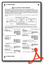
Weather Minimums

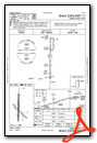
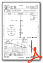
Instrument Approach Procedure (IAP) Charts
Nearby Airports with Instrument Procedures
| ID | Name | Heading / Distance | ||
|---|---|---|---|---|
 |
KMCK | Mc Cook Ben Nelson Regional Airport | 353° | 22.4 |
|
KADT | Atwood-Rawlins County City-County Airport | 271° | 23.2 |
|
KNRN | Norton Municipal Airport | 087° | 29.8 |
|
KCSB | Cambridge Municipal Airport | 031° | 33.2 |
|
KCBK | Shalz Field Airport | 224° | 33.9 |
|
KHLC | Hill City Municipal Airport | 129° | 42.7 |
|
KOEL | Oakley Municipal Airport | 196° | 45.2 |
|
47V | Curtis Municipal Airport | 003° | 48.3 |
|
1QK | Gove County Airport | 163° | 49.8 |
|
KPHG | Phillipsburg Municipal Airport | 095° | 56.8 |
|
4D9 | Alma Municipal Airport | 072° | 57.5 |
|
0H1 | Trego Wakeeney Airport | 148° | 58.0 |
Airport Images
Do you have a recent image of this airport? Upload it here!


