Login
Register


HOM
Homer Airport
Official FAA Data Effective 2026-01-22 0901Z
Chart Supplement

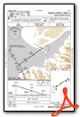
PAHO Airport Diagram

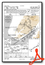
VFR Chart of PAHO
Sectional Charts at SkyVector.com
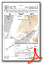
IFR Chart of PAHO
Enroute Charts at SkyVector.com
Location Information for PAHO
Coordinates: N59°38.73' / W151°28.60'Located 02 miles E of Homer, Alaska on 1040 acres of land. View all Airports in Alaska.
Surveyed Elevation is 84 feet MSL.
Operations Data
|
|
Airport Communications
| ASOS: | 135.65 Tel. 907-235-3603 |
|---|---|
| CTAF: | 123.600 |
| ASOS at SOV (14.0 SW): | 135.4 907-234-7407 |
| AWOS-3P at SXQ (51.7 N): | 135.45 907-262-8431 |
| ATIS at ENA (56.1 N): | 133.35 |
- APCH/DEP SVC PRVDD BY ANCHORAGE ARTCC ON FREQS 125.9/270.3 (HOMER RCAG).
- HOM AFIS ON FREQUENCY 135.65. OPERATES SAME HRS AS HOM FSS, 0600-2130; OT CTC KENI FSS.
- COMMUNICATIONS PRVDD BY HOMER FSS ON FREQ 123.6 (CTAF).
Nearby Navigation Aids
|
| ||||||||||||||||||||||||||||||


Runway 04/22
LINE OF SIGHT BTN RWY ENDS NA. | ||
| Dimensions: | 6701 x 100 feet / 2042 x 30 meters | |
|---|---|---|
| Surface: | Asphalt / Grooved in Poor Condition | |
| Weight Limits: | S-62, D-70, ST-189
PCR VALUE: 511/F/A/X/T
| |
| Edge Lighting: | High Intensity | |
| Runway 04 | Runway 22 | |
| Coordinates: | N59°38.42' / W151°29.49' | N59°39.05' / W151°27.71' |
| Elevation: | 70.5 | 74.3 |
| Traffic Pattern: | Right | Left |
| Runway Heading: | 55° True | 235° True |
| Markings: | Precision Instrument in poor condition. | Precision Instrument in fair condition. |
| Glide Slope Indicator | P4L (3.00° Glide Path Angle) | P4L (3.00° Glide Path Angle) |
| Approach Lights: | MALSF 1,400 Foot Medium-intensity Approach Lighting System with sequenced flashers. | MALSR 1,400 Foot Medium-intensity Approach Lighting System with runway alignment indicator lights. |
| Obstacles: | 31 ft Antenna 522 ft from runway, 520 ft left of center | 74 ft Tree 2269 ft from runway, 425 ft right of center |
Services Available
| Fuel: | 100LL (blue), Jet-A |
|---|---|
| Transient Storage: | Hangars,Tiedowns |
| Airframe Repair: | MINOR |
| Engine Repair: | MINOR |
| Bottled Oxygen: | NOT AVAILABLE |
| Bulk Oxygen: | NOT AVAILABLE |
| Other Services: | CARGO HANDLING SERVICES |
Ownership Information
| Ownership: | Publicly owned | |
|---|---|---|
| Owner: | ALASKA DOT&PF CENTRAL REGION | |
| PO BOX 196900 | ||
| ANCHORAGE, AK 99519-6900 | ||
| 907-269-0555 | ||
| Manager: | MATTHEW BLAINE | |
| 2320 KACHEMAK DR | ||
| HOMER, AK 99603 | ||
| 907-235-4394 | ||
Other Remarks
- 365 FT UNLGT TWR 9 NM W.
- PAEW MAY BE ON RWY H24.
- TPA 800 FT AGL FOR FIXED WING ACFT; TPA 600 FT AGL & BLO FOR ROTARY ACFT.
- RWY COND, SNOW/ICE RPRT & REMOVAL, WILDLIFE CTL OR OTR SVC AVBL DURG SKED MAINT HR; AFT HR SVC - AMGR.
- TWY D CLSD; TWY A, B SOUTH & E CLSD TO ACFT OVR 12500 LB.
- SAND GRADATION LRGR THAN FAA RCMDD; SEE AC150/5200-30.
- WX CAMERA AVBL ON INTERNET AT HTTP://WEATHERCAMS.FAA.GOV.
- SEA BIRDS & WATER FOWL ON & INVOF ARPT DURG SPRING & SUMMER.
- NOISE ABATEMENT IN EFCT H24; TURNS BFR DEP END RWY 04/22 NA AT HOMER & SPB; RPRT OBS DEV TO FAA SAFETY HOTLINE.
- GA TSNT PRKG S SIDE OF RWY.
- GRVL ROAD S SIDE OF RWY CLSD TO ACFT; TAX NA.
- PPR FOR ACR OPS MORE THAN 30 PAX SEATS IN WRITING - AMGR: 2320 KACHEMAK DR. HOMER; AK 99603.
- ACTVT MALSF RWY 04; MALSR RWY 22; PAPI RWY 04 & 22; HIRL RWY 04/22 - CTAF.
Weather Minimums


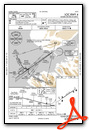
Instrument Approach Procedure (IAP) Charts


Nearby Airports with Instrument Procedures
| ID | Name | Heading / Distance | ||
|---|---|---|---|---|
 |
PASX | Soldotna Airport | 014° | 51.6 |
|
PAEN | Kenai Municipal Airport | 007° | 56.2 |
|
PAWD | Seward Airport | 064° | 68.8 |
|
PAKX | Wilder Runway Airport | 292° | 92.2 |
|
PANC | Ted Stevens Anchorage International Airport | 024° | 101.9 |
|
PAMR | Merrill Field Airport | 026° | 106.1 |
|
PAED | Elmendorf AFB Airport | 026° | 108.6 |
|
PADQ | Kodiak Airport | 196° | 118.4 |
|
PAGQ | Big Lake Airport | 022° | 123.9 |
|
PAWS | Wasilla Airport | 025° | 129.3 |
|
PAAQ | Warren "Bud" Woods Palmer Municipal Airport | 030° | 136.9 |
Airport Images
Do you have a recent image of this airport? Upload it here!


