Login
Register


MRI
Merrill Field Airport
Official FAA Data Effective 2026-02-19 0901Z
Chart Supplement

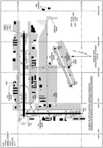
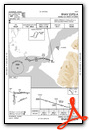
PAMR Airport Diagram
VFR Chart of PAMR
Sectional Charts at SkyVector.com
IFR Chart of PAMR
Enroute Charts at SkyVector.com
Location Information for PAMR
Coordinates: N61°12.81' / W149°50.68'Located 02 miles E of Anchorage, Alaska on 436 acres of land. View all Airports in Alaska.
Surveyed Elevation is 143 feet MSL.
TPA FOR ACFT 105 KTS OR LESS 900 FT MSL. ACFT GREATER THAN 105 KTS 1200 FT MSL.
Operations Data
|
|
Airport Communications
| ATIS: | 124.25 |
|---|---|
| ASOS: | 124.25 Tel. 907-271-5277 |
| MERRILL TOWER: | 126.0 127.55 |
| MERRILL GROUND: | 121.7 |
| ANCHORAGE APPROACH: | 119.1 363.2 |
| ANCHORAGE DEPARTURE: | 119.1 363.2 |
| CTAF: | 126.000 |
| UNICOM: | 122.950 |
| CLASS C: | 119.1 363.2 |
| ATIS at EDF (2.5 NE): | 273.5 |
| ATIS at LHD (3.8 SW): | 125.6 |
| ASOS at LHD (4.2 SW): | 125.6 907-245-5432 |
- INTERFERENCE MAY BE RECEIVED ON ATCT FREQS IN TRAFFIC PATTERN FROM FM BROADCAST STATION.
- WHEN ATCT CLSD CTAF PROCEDURES ARE RECOMMENDED. SEE REGULATORY NOTICES ANCHORAGE TERMINAL AREA MERRILL SEGMENT THIS SUPPLEMENT.
- WHEN ATCT CLSD WX ALSO AVBL ON CTAF, CALL SIGN MERRILL WEATHER OR PHONE 907-271-4355.
Nearby Navigation Aids
|
| ||||||||||||||||||||||||||||||||||||||||||


Runway 07/25
| Dimensions: | 4000 x 100 feet / 1219 x 30 meters | |
|---|---|---|
| Surface: | Asphalt in Good Condition | |
| Weight Limits: | S-50, D-80 | |
| Edge Lighting: | Medium Intensity | |
| Runway 07 | Runway 25 | |
| Coordinates: | N61°12.95' / W149°51.20' | N61°12.95' / W149°49.84' |
| Elevation: | 131.0 | 143.1 |
| Traffic Pattern: | Right | Left |
| Runway Heading: | 90° True | 270° True |
| Markings: | Precision Instrument in good condition. | Precision Instrument in good condition. |
| Glide Slope Indicator | P4R (3.50° Glide Path Angle) | P4L (3.00° Glide Path Angle) |
| REIL: | Yes | Yes |
| Obstacles: | 41 ft Pole 846 ft from runway, 339 ft left of center | |
Runway 16/34
| Dimensions: | 2640 x 75 feet / 805 x 23 meters | |
|---|---|---|
| Surface: | Asphalt in Fair Condition | |
| Weight Limits: | S-20 | |
| Edge Lighting: | Medium Intensity | |
| Runway 16 | Runway 34 | |
| Coordinates: | N61°12.94' / W149°51.15' | N61°12.51' / W149°51.15' |
| Elevation: | 130.8 | 123.3 |
| Traffic Pattern: | Right | Left |
| Runway Heading: | 180° True | 0 |
| Markings: | Basic in fair condition. | Basic in fair condition. |
| Glide Slope Indicator | V2R (3.00° Glide Path Angle) | P2L (3.00° Glide Path Angle) |
| REIL: | Yes | Yes |
| Obstacles: | 31 ft Building 437 ft from runway, 268 ft left of center | 27 ft Pole 331 ft from runway, 231 ft left of center |
Runway 05/23
USED SEASONALLY AS SNOW RWY. RCMD SKI EQUIP ACFT USE TO MINIMIZE WHEEL RUTTING. | ||
| Dimensions: | 2000 x 60 feet / 610 x 18 meters | |
|---|---|---|
| Surface: | Asphalt-Gravel in Good Condition FIRST 60 FT PAVED; RMNG GRVL. | |
| Runway 05 | Runway 23 | |
| Coordinates: | N61°12.58' / W149°50.71' | N61°12.71' / W149°50.09' |
| Elevation: | 133.2 | 138.0 |
| Runway Heading: | 66° True | 246° True |
| Markings: | in good condition. | in good condition. |
| Obstacles: | 7 ft Fence 250 ft from runway, 115 ft right of center | |
Services Available
| Fuel: | 100 (green), Jet-A |
|---|---|
| Transient Storage: | Hangars,Tiedowns |
| Airframe Repair: | MAJOR |
| Engine Repair: | MAJOR |
| Bottled Oxygen: | LOW |
| Bulk Oxygen: | LOW |
| Other Services: | AIR FREIGHT SERVICES,AIR AMBULANCE SERVICES,AVIONICS,CARGO HANDLING SERVICES,CHARTER SERVICE,PILOT INSTRUCTION,AIRCRAFT RENTAL,AIRCRAFT SALES,ANNUAL SURVEYING |
Ownership Information
| Ownership: | Publicly owned | |
|---|---|---|
| Owner: | MUNICIPALITY OF ANCHORAGE | |
| 800 MERRIL FIELD DR. | ||
| ANCHORAGE, AK 99501-4129 | ||
| 907-343-6303 | ||
| Manager: | EARL MALPASS | |
| 800 MERRIL FIELD DR | ||
| ANCHORAGE, AK 99501-4129 | ||
| 907-343-6301 | ||
Other Remarks
- WHEN ATCT CLSD CTC MERRILL WX - CTAF OR 271-4355.
- FLT PLANNING IN ANCHORAGE BOWL AREA - RCO 122.55.
- NONMOVEMENT AREA ACFT CTC GND CTL BFR TAX.
- ANCHORAGE WX CAMERA AVBL ON INTERNET AT HTTPS://WEATHERCAMS.FAA.GOV
- PTNS OF TWY C BTN TWY S & N AND PTNS OF TWY Q NOT VIS FM TWR.
- TWY B SOUTH OF TWY M, TWY G BTN TWY N & RWY 05/23, TWY Q EAST OF TWY C & ALL SFCS SOUTH OF RWY 05/23 UNCTLD.
- COMPASS ROSE AVBL WITH PRIOR CDN - ATCT.
- ARR/DEP ROUTES - SEE AREA NOTICES; SPL NOTICE CARTEE ASP.
- NOISE ABATEMENT; TGL OR PAT WORK NA 2200-0700.
- ALASKA RGNL HOSPITAL 2OK HELI ON ARPT; SEE SEPARATE LISTING FOR INFO.
- BIRDS & SEAGULLS ON & INVOF ARPT.
- PPR OVR 12500 LB.
- ALL RWY & TWY LGTS NONSTD HEIGHT.
- 1-8 FT SNOW BERMS ADJ TO RWYS & TWYS DURG WINTER.
- ACTVT REIL RWY 07, 16, 25, 34; MIRL RWY 07/25 & 16/34 - CTAF. PAPI RWY 07, 25 & 34; VASI RWY 16 OPR CONSLY.
- TPA FOR ACFT 105 KTS OR LESS 900 FT MSL. ACFT GREATER THAN 105 KTS 1200 FT MSL.
Weather Minimums

Instrument Approach Procedure (IAP) Charts

Departure Procedure (DP) Charts

Nearby Airports with Instrument Procedures
| ID | Name | Heading / Distance | ||
|---|---|---|---|---|
 |
PAED | Elmendorf AFB Airport | 025° | 2.5 |
|
PANC | Ted Stevens Anchorage International Airport | 242° | 5.0 |
|
PAGQ | Big Lake Airport | 002° | 19.3 |
|
PAWS | Wasilla Airport | 022° | 23.3 |
|
PAAQ | Warren "Bud" Woods Palmer Municipal Airport | 043° | 31.7 |
|
PAUO | Willow Airport | 349° | 33.1 |
|
PAEN | Kenai Municipal Airport | 227° | 56.3 |
|
PASX | Soldotna Airport | 218° | 56.6 |
|
PAWD | Seward Airport | 168° | 66.4 |
|
PATK | Talkeetna Airport | 354° | 67.0 |
|
PAHO | Homer Airport | 207° | 106.1 |
Airport Images
 Anchorage, Alaska")
By: rcombellick
 Anchorage, Alaska")
By: rcombellick


