Login
Register


EWK
Newton-City-County Airport
Official FAA Data Effective 2026-02-19 0901Z
Chart Supplement

VFR Chart of KEWK
Sectional Charts at SkyVector.com
IFR Chart of KEWK
Enroute Charts at SkyVector.com
Location Information for KEWK
Coordinates: N38°3.43' / W97°16.51'Located 03 miles E of Newton, Kansas on 635 acres of land. View all Airports in Kansas.
Estimated Elevation is 1533 feet MSL.
Operations Data
|
|
Airport Communications
| AWOS-3PT: | 123.875 Tel. 316-283-8789 |
|---|---|
| WICHITA APPROACH: | 125.5 306.2 |
| WICHITA DEPARTURE: | 125.5 306.2 |
| CLEARANCE DELIVERY: | 126.55 |
| UNICOM: | 123.000 |
| CTAF: | 123.000 |
| AWOS-2 at 1K1 (18.6 SE): | 118.3 316-530-6004 |
| ASOS at AAO (18.8 S): | 134.025 316-636-2541 |
| AWOS-3PT at BEC (22.0 S): | 119.45 316-515-7116 |
Nearby Navigation Aids
|
| ||||||||||||||||||||||||||||||||||||||||||||||||||||||||||||


Runway 17/35
| Dimensions: | 7003 x 100 feet / 2135 x 30 meters | |
|---|---|---|
| Surface: | Concrete in Good Condition | |
| Weight Limits: | 21 /R/C/X/U, S-50, D-75, ST-135 | |
| Edge Lighting: | High Intensity | |
| Runway 17 | Runway 35 | |
| Coordinates: | N38°3.89' / W97°16.58' | N38°2.74' / W97°16.58' |
| Elevation: | 1528.8 | 1524.5 |
| Traffic Pattern: | Left | Left |
| Runway Heading: | 180° True | 0 |
| Declared Distances: | TORA:7003 TODA:7003 ASDA:6705 LDA:6705 | TORA:7003 TODA:7003 ASDA:7003 LDA:7003 |
| Markings: | Precision Instrument in good condition. | Non-Precision Instrument in good condition. |
| Glide Slope Indicator | P2L (3.00° Glide Path Angle) | V4L (3.00° Glide Path Angle) |
| Approach Lights: | MALSR 1,400 Foot Medium-intensity Approach Lighting System with runway alignment indicator lights. | |
| REIL: | Yes | |
Runway 08/26
| Dimensions: | 3501 x 60 feet / 1067 x 18 meters | |
|---|---|---|
| Surface: | Asphalt in Good Condition | |
| Weight Limits: | 6 /F/D/Y/U, S-13 | |
| Edge Lighting: | Medium Intensity | |
| Runway 08 | Runway 26 | |
| Coordinates: | N38°3.65' / W97°16.74' | N38°3.65' / W97°16.01' |
| Elevation: | 1533.5 | 1533.3 |
| Runway Heading: | 90° True | 270° True |
| Declared Distances: | TORA:3501 TODA:3501 ASDA:3501 LDA:3501 | TORA:3501 TODA:3501 ASDA:3501 LDA:3501 |
| Markings: | Basic in good condition. | Basic in good condition. |
| Glide Slope Indicator | P4L (3.00° Glide Path Angle) | P4L (3.00° Glide Path Angle) |
| REIL: | Yes | Yes |
| Obstacles: | 34 ft Pole 841 ft from runway, 272 ft right of center | |
Services Available
| Fuel: | 100LL (blue), Jet-A |
|---|---|
| Transient Storage: | Hangars,Tiedowns |
| Airframe Repair: | MAJOR |
| Engine Repair: | MAJOR |
| Bottled Oxygen: | NONE |
| Bulk Oxygen: | LOW |
| Other Services: | CHARTER SERVICE,PILOT INSTRUCTION,AIRCRAFT SALES |
Ownership Information
| Ownership: | Publicly owned | |
|---|---|---|
| Owner: | CITY OF NEWTON HARVEY CO | |
| 810 N. OLIVER ROAD - BOX 426 | ||
| NEWTON, KS 67114 | ||
| 316-284-6089 | ||
| Manager: | BRIAN PALMER | |
| P.O. BOX 426 | ||
| NEWTON, KS 67114 | ||
| 316-284-6084 | ||
Other Remarks
- NO LINE OF SIGHT BETWEEN RWY ENDS.
- SELF-SERVE AIRCRAFT WASH BAY.
- COMPASS ROSE RIGHT OF APCH END RY 35
- FOR CD CTC WICHITA APCH AT 316-350-1520.
- ACTVT MALSR RWY 17; REIL RWYS 08 & 26 &35; VASI RWY 35; PAPI RWYS 08 & 26 & 17; HIRL RWY 17/35 - CTAF.
Weather Minimums


Instrument Approach Procedure (IAP) Charts


Nearby Airports with Instrument Procedures
| ID | Name | Heading / Distance | ||
|---|---|---|---|---|
 |
47K | Moundridge Municipal Airport | 310° | 14.1 |
|
1K1 | Lloyd Stearman Field Airport | 155° | 18.6 |
|
KAAO | Colonel James Jabara Airport | 172° | 18.7 |
|
KBEC | Beech Factory Airport | 172° | 22.0 |
|
KCEA | Cessna Acft Field Airport | 177° | 24.5 |
|
3AU | Augusta Municipal Airport | 157° | 25.0 |
|
KICT | Wichita Dwight D Eisenhower Ntl Airport | 197° | 25.5 |
|
KIAB | Mc Connell AFB Airport | 179° | 26.0 |
|
KMPR | Mc Pherson Airport | 312° | 26.5 |
|
KEQA | El Dorado/Capt Jack Thomas Memorial Airport | 127° | 27.6 |
|
KHUT | Hutchinson Regional Airport | 271° | 27.7 |
|
K50 | Cook Airfield Airport | 170° | 29.9 |
Airport Images
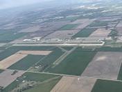
By: skydvrboy


