Login
Register


CEA
Cessna Acft Field Airport
Official FAA Data Effective 2026-01-22 0901Z
Chart Supplement

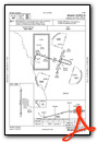
VFR Chart of KCEA
Sectional Charts at SkyVector.com
IFR Chart of KCEA
Enroute Charts at SkyVector.com
Location Information for KCEA
Coordinates: N37°38.92' / W97°15.04'Located 04 miles SE of Wichita, Kansas on 900 acres of land. View all Airports in Kansas.
Surveyed Elevation is 1378 feet MSL.
Operations Data
|
|
Airport Communications
| WICHITA APPROACH: | 134.8 269.1 |
|---|---|
| WICHITA DEPARTURE: | 134.8 269.1 |
| CLEARANCE DELIVERY: | 125.0 |
| CTAF: | 122.900 |
| D-ATIS at IAB (1.7 SW): | 269.9 |
| AWOS-3PT at BEC (3.2 NE): | 119.45 316-515-7116 |
| ASOS at AAO (6.1 N): | 134.025 316-636-2541 |
Nearby Navigation Aids
|
| ||||||||||||||||||||||||||||||||||||||||||||||||||||||||||||


Runway 17/35
| Dimensions: | 3873 x 40 feet / 1180 x 12 meters | |
|---|---|---|
| Surface: | Asphalt in Good Condition | |
| Runway 17 | Runway 35 | |
| Coordinates: | N37°39.23' / W97°15.04' | N37°38.60' / W97°15.04' |
| Elevation: | 1373.0 | 1373.0 |
| Traffic Pattern: | Left | Right |
| Runway Heading: | 180° True | 0 |
| Displaced Threshold: | 150 Feet | 150 Feet |
| Markings: | Basic in fair condition. | Basic in fair condition. |
| Obstacles: | 10 ft Road 252 ft from runway OBSTN CLNC SLP 20:1 TO DTHR OVR 23 FT TREE, 475 FT DSTC, 50 FT R. |
13 ft Road 210 ft from runway OBSTN CLNC SLP 27:1 TO DTHR. 8 FT FENCE 170 FT FM RWY END. |
Services Available
| Fuel: | NONE |
|---|---|
| Transient Storage: | NONE |
| Airframe Repair: | NONE |
| Engine Repair: | NONE |
| Bottled Oxygen: | NONE |
| Bulk Oxygen: | NONE |
Ownership Information
| Ownership: | Privately Owned | |
|---|---|---|
| Owner: | CESSNA AIRCRAFT COMPANY | |
| 10511 EAST CENTRAL | ||
| WICHITA, KS 67277 | ||
| 316-515-6000 | ||
| Manager: | TODD BAYLESS | |
| 10511 EAST CENTRAL | ||
| WICHITA, KS 67201 | ||
| 316-515-8365 | ||
Other Remarks
- THIS AIRPORT HAS BEEN SURVEYED BY THE NATIONAL GEODETIC SURVEY.
- ACFT OPNS SHOULD COORDINATE WITH MC CONNELL AFB PRIOR TO ARRIVAL AND DEP - CONTROL TOWER 127.25.
- RWY 17R/35L USED ONLY BY CESSNA PERSONNEL; CLOSED TO PUBLIC.
- FOR CD CTC WICHITA APCH AT 316-350-1520.
Instrument Approach Procedure (IAP) Charts
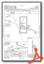
Nearby Airports with Instrument Procedures
| ID | Name | Heading / Distance | ||
|---|---|---|---|---|
 |
KIAB | Mc Connell AFB Airport | 207° | 1.7 |
|
KBEC | Beech Factory Airport | 032° | 3.2 |
|
KAAO | Colonel James Jabara Airport | 013° | 6.1 |
|
K50 | Cook Airfield Airport | 143° | 6.2 |
|
3AU | Augusta Municipal Airport | 081° | 8.3 |
|
KICT | Wichita Dwight D Eisenhower Ntl Airport | 270° | 8.7 |
|
1K1 | Lloyd Stearman Field Airport | 040° | 10.0 |
|
KEGT | Wellington Municipal Airport | 198° | 20.5 |
|
KEQA | El Dorado/Capt Jack Thomas Memorial Airport | 069° | 21.9 |
|
KEWK | Newton-City-County Airport | 357° | 24.5 |
|
KWLD | Strother Field Airport | 160° | 30.5 |
|
47K | Moundridge Municipal Airport | 340° | 35.7 |
Airport Images
Do you have a recent image of this airport? Upload it here!


